Teacher GuideâEarth Science Module - Estuaries NOAA
Teacher GuideâEarth Science Module - Estuaries NOAA
Teacher GuideâEarth Science Module - Estuaries NOAA

You also want an ePaper? Increase the reach of your titles
YUMPU automatically turns print PDFs into web optimized ePapers that Google loves.
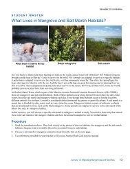
2g. When you arrive at Blakely Island Reach in Mobile, Alabama, how has the terrain on both rivers changed?2h. Center the river and fly south until you see Gaillard Island. Find latitude 30 30' 31" (on the right shorelineof the island) and zoom in. Describe what you see.2i. Move back to 4 km of altitude, and fly directly south from Gaillard Island to Mobile Point. Zoom in anddescribe the terrain you see.2j. Now fly east and explore the region to the north of the beach area beginning with Navy Cove. Describe thetypes of features and terrain you find there.2k. Now fly directly north across the bay until you reach Weeks Bay National Estuarine Research Reserve.Can you identify a sediment plume at the mouth of the bay? Identify other features in the neighborhood of theestuary reserve.Earth <strong>Science</strong> <strong>Module</strong>—Activity 16