Teacher GuideâEarth Science Module - Estuaries NOAA
Teacher GuideâEarth Science Module - Estuaries NOAA
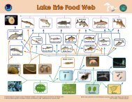
Teacher GuideâEarth Science Module - Estuaries NOAA

You also want an ePaper? Increase the reach of your titles
YUMPU automatically turns print PDFs into web optimized ePapers that Google loves.
The river flows west to Selma, then southwest until it isabout 72 km from Mobile where it unites with theTombigbee River, forming the Mobile and TensawRivers. Both rivers discharge into Mobile Bay.The Alabama River meanders a lot. It is 502 km longand varies in width from 200 to 300 m, and its depthranges from 1 to 2 m. The river crosses the richestagricultural and timber districts of the state, and railwaysconnect it with the mineral regions of north centralAlabama.See the PowerPoint Estuary Landforms and Features formore background information on the major landformsand features of estuaries.Download and prepare to present the PowerPointEstuary Landforms and Features.PreparationDownload Google Earth and install it on your classroomcomputer(s) or computer lab machines. To find atutorial for using Google Earth, please check the box onthe next page.Preset the locations of your school and the beginning ofthe Alabama River trip (31 08' 53.46 N, 87 56' 56.46W; altitude 4 km) in Google Earth. Refer to Using GoogleEarth to Explore <strong>Estuaries</strong> for a brief how-to guide. (Seeside-box for instructions on how to access this tutorial.)In Google Earth, choose a starting point for students’Part 3 exploration of a coastal area and determine anaddress or location name to enter that will zoom in onthis starting place. For example, if you want yourstudents to begin exploring the coast of the Gulf ofMexico, a starting location might be Port Isabel, Texas.Or select one of the National Estuarine ResearchReserves for students to investigate.MaterialsBrowse the coastal area that you want your students toexamine and identify potentially confusing borders orareas with only low-resolution imagery available.StudentsNeed to work in a computer lab or with acomputer and projectorCopy of the Student ReadingObserving <strong>Estuaries</strong>Copy of the Student WorksheetObserving <strong>Estuaries</strong>Copy of Student ReadingIntroduction to Weeks Bay NERRCopy of Student Worksheet — Scavenger HuntCopy of Student ReadingUsing Google Earth to Explore <strong>Estuaries</strong>(assuming you have computer access)<strong>Teacher</strong>sDownload Google EarthIf you wish to use hardcopy materials instead ofGoogle Earth, obtain topographic or other typesof maps for students to use in Part 2 of theactivityPowerPoint Estuary Landforms and Features(available on the <strong>Estuaries</strong>.noaa.gov site, clickunder Curriculum, High-School Curriculum, Earth<strong>Science</strong>, and find the presentation underSupporting Materials, Activity 1)Equipment:Computer lab orComputer and ProjectorEarth <strong>Science</strong> <strong>Module</strong>—Activity 12