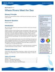
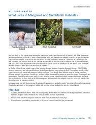
Student Reading—1Activity 3: Estuary and WatershedA watershed, also called a drainage basin, is the area inwhich all water, sediments, and dissolved materialsdrain from the land into a common body of water, suchas a river, lake, estuary, or ocean. A watershedencompasses not only the water but also the surroundingland from which the water drains. Watersheds rangein size from huge areas like the Mississippi Riverdrainage basin to small areas like your backyard.banks and shorelines by maintaining vegetatedbuffer strips, treating all wastes to removeharmful pollutants, or using grass-linedcatchment basins in urban areas to trapsediment and pollutants. Also, protectingwetlands is essential since they are important inslowing runoff, absorbing floodwaters, and cleaningstorm water.Whether large or small, a watershed’s characteristics cangreatly affect how water flows through it. Heavy stormsmay cause streams to rise rapidly. Human-madefeatures of the watershed like dams or large paved areascan change stream flow and alter the watershed. If theterrain is steep, changes in stream flow due to runoffcan be significant.In some watersheds, stream flow may take a long timeto respond to rainfall runoff. On heavily vegetated,relatively flat terrain, much of the rainfall is absorbed bythe soil and the vegetation slows runoff. In these areas,stream flow will rise slowly, but also recede slowly. Onsteep terrain with a scarcity of vegetation, heavy raincan cause rapid stream flow and runoff with very littleabsorption by the ground. These grade changes createdifferent habitats in the stream that support differentforms of life and change the quality of water in thewatershed.Water quality is critically impacted by everything thatgoes on within the watershed. Mining, forestry,agriculture, and construction practices, urban runofffrom streets, parking lots, chemically-treated lawns andgardens, failing septic systems, and improperly treatedmunicipal sewage discharges all affect water quality.Reducing pollution and protecting water qualityrequires identifying, regulating, monitoring, andcontrolling potential sources of pollution. Someexamples of control practices include protecting stream<strong>Estuaries</strong> lie at the mouth of watersheds. San FranciscoBay is a shallow, extremely large estuary that drainsabout forty percent of California. Nearly ninety percentof the fresh water flowing into the bay comes from theSacramento and San Joaquin rivers. Technically, bothrivers flow into Suisun Bay, which flows through theCarquinez Strait to meet with the Napa River at theentrance to San Pablo Bay, which then connects at itssouth end to San Francisco Bay. This entire group ofinterconnected bays is referred to as San Francisco Bay.San Francisco Bay has lost approximately 80-90% of itshistoric tidal wetlands due to human and industrialactivities within and around the bay. Tidal wetlands arecritical for flood prevention; sediment management;and habitats for small mammals, migratory birds andfish species, many of which are threatened andendangered.What happens upstream can affect the quality of waterand the living conditions for organisms that live in thetidal estuary. In this activity, you will investigate the SanFrancisco Bay watershed and estuary.The North or San Pablo Bay receiveshe waters of the Sacramento andSan Joaquin rivers via Suisun Bayand the Carquinez Strait on its eastend, and it connects to San FranciscoBay on its south end.Earth <strong>Science</strong> <strong>Module</strong>—Activity 3
Student Reading—1Continues…. Activity 3: Estuary and WatershedSan Pablo Bay is a primary wintering stop for thecanvasback duck population on the Pacific Flyway, aswell as a migratory staging ground for numerous speciesof waterfowl. Endangered species that are foundin the bay include the salt marsh harvest mouse.Endangered saltwater fishes found in the bay includestriped bass, sturgeon, starry flounder, leopard shark,and anchovy. The southwestern end, near the townof San Rafael, was the site of a Chinese shrimpfishingvillage where some 500 people lived in the1880s, sending some 90% of their catch of bayshrimp back to China. The location is now part ofChina Camp State Park, which is part of the SanFrancisco Bay National Estuarine Research Reserve(NERR). The water quality data you will examine inPart 3 of this activity was taken at this site.Figure 1. San Pablo Bay or North BayEarth <strong>Science</strong> <strong>Module</strong>—Activity 32