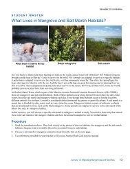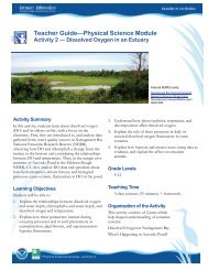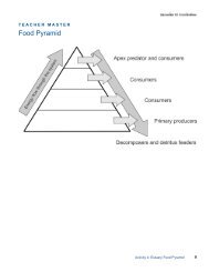
Teacher GuideâEarth Science Module - Estuaries NOAA
Teacher GuideâEarth Science Module - Estuaries NOAA
Teacher GuideâEarth Science Module - Estuaries NOAA

You also want an ePaper? Increase the reach of your titles
YUMPU automatically turns print PDFs into web optimized ePapers that Google loves.
Part 2 — A Trip Down the Alabama River4. Explain to students that they will now take a tripdown a river in Alabama to investigate one type ofestuary and the kinds of features that are presentwhen a river meets the sea.5. Show students an image of their school in GoogleEarth at an altitude of 4 km. Ask students if theyrecognize the image and its location. You may haveto point out a few familiar landmarks.6. Ask students to describe the environment aroundtheir school, pointing out the specific landforms andfeatures they see. (Ponds, rivers, streams, lakes, hills,canyons, and valleys are commonly mentioned, or there mayonly be city streets.)7. Demonstrate how to zoom in and out, move leftand right, and up and down using Google Earth.Also show students how to leave a place mark on aGoogle image. Distribute Student Reading — UsingGoogle Earth to Explore <strong>Estuaries</strong>.8. Click on the placeholder for the beginning of theAlabama River trip if you have marked it or go to:31 08' 53.46 N, 87 56' 56.46 W. Ask students whatkinds of features they see in the image. (Sand bars,farmland, forests, and a tributary flowing into the AlabamaRiver)Check for UnderstandingDiscuss the following:How do the terrain and types of landforms change asyou travel down a river toward a source of salt water?Which of the landforms and features on your scavengerhunt list were fairly common?9. Hand out Student Worksheet — Observing <strong>Estuaries</strong>.Instruct students to explore the Alabama River,following the directions and answering the questionson the worksheet.Part 3 — Estuary Landforms and FeaturesScavenger Hunt10. Divide your class into teams and hand out theStudent Worksheet — Scavenger Hunt.11. Show the Estuary Landforms and Features PowerPointpresentation so students have a basis for selectingfeatures in the scavenger hunt.12. In Google Earth, have the teams go to yourpre-selected starting point and challenge them tolocate as many of the features as they can in 30minutes.13. Have teams exchange lists and verify the objects oneach other’s lists. Have students place questionmarks on features that they either cannot find orthose they feel are misidentified.14. Have students answer the summary questions.Optional Extension InquiriesHave students create a travelogue that documents a tripdown a river that flows into another NERRS estuary.Have students make a PowerPoint presentation that describesthe differences between the geological landformsand features in upland versus estuarine environments.Which landforms were not present at all?Have students sketch an imaginary estuary system on apiece of paper. Direct them to draw and label as manylandforms and features on their diagram as possible. Collectand evaluate them for accuracy, clarity, and the numberof landforms correctly identified.Earth <strong>Science</strong> <strong>Module</strong>—Activity 14