OBSERVATION
CEOS EOHB tables June 2012 web - ceos eo handbook
CEOS EOHB tables June 2012 web - ceos eo handbook
- No tags were found...
You also want an ePaper? Increase the reach of your titles
YUMPU automatically turns print PDFs into web optimized ePapers that Google loves.
Mission Status Launch Date EOL Date Applications Instruments Orbit Details & URL<br />
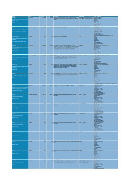
GOES-S<br />
Approved Feb 2017 Oct 2028 Meteorology (primary mission), search and rescue, space ABI, GLM, Magnetometer (NOAA), Type: Geostationary<br />
environment monitoring, data collection platform, data gathering, EXIS, SEISS, SUVI, DCS (GOES-R) Altitude: 36000 km<br />
Geostationary Operational Environmental<br />
WEFAX.<br />
Period:<br />
Satellite - S<br />
Inclination:<br />
Repeat cycle:<br />
NOAA<br />
LST:<br />
Longitude (if geo):<br />
Asc/desc: N/A<br />
URL: www.goes-r.gov/<br />
GOSAT<br />
Currently being flown 23 Jan 2009 Jan 2014 Observation of greenhouse gases. TANSO-CAI, TANSO-FTS Type: Sun-synchronous<br />
Altitude: 666 km<br />
Greenhouse gases Observing SATellite<br />
Period: 98.18 mins<br />
Inclination: 98.06 deg<br />
JAXA / MOE (Japan) / NIES (Japan)<br />
Repeat cycle: 3 days<br />
LST: 13:00<br />
Longitude (if geo):<br />
Asc/desc: Descending<br />
URL: www.jaxa.jp/projects/sat/gosat/index_e.html<br />
GOSAT Follow-On<br />
Planned 2016 2021 Observation of greenhouse gases. FTS Type:<br />
Altitude:<br />
Greenhouse gases Observing SATellite<br />
Period:<br />
Follow-On<br />
Inclination:<br />
Repeat cycle:<br />
JAXA / MOE (Japan) / NIES (Japan)<br />
LST:<br />
Longitude (if geo):<br />
Asc/desc: Descending<br />
URL:<br />
GPM Core<br />
Approved Feb 2014 Feb 2017 3-year nominal mission life, 5-year goal. Study of global GMI, DPR<br />
Type: Inclined, non-sun-synchronous<br />
precipitation, evaporation, and cycling of water are changing. The<br />
Altitude: 407 km<br />
Global Precipitation Measurement Mission<br />
mission comprises a primary spacecraft with active and passive<br />
Period: 95 mins<br />
Core spacecraft<br />
microwave instruments, and a number of ‘constellation<br />
Inclination: 65 deg<br />
spacecraft' with passive microwave instruments.<br />
Repeat cycle:<br />
NASA / JAXA<br />
LST:<br />
Longitude (if geo):<br />
Asc/desc: TBD<br />
URL: gpm.gsfc.nasa.gov<br />
GRACE<br />
Currently being flown 17 Mar 2002 Sep 2013 5-year nominal mission life, currently in extended operations. GRACE instrument<br />
Type: Inclined, non-sun-synchronous<br />
Extremely high precision gravity measurements for use in<br />
Altitude: 400 km<br />
Gravity Recovery and Climate Experiment<br />
construction of gravity field models. GRACE consists of two<br />
Period: 94 mins<br />
satellites (A, B) serving one mission.<br />
Inclination: 89 deg<br />
NASA / DLR<br />
Repeat cycle:<br />
LST:<br />
Longitude (if geo):<br />
Asc/desc: TBD<br />
URL: www.csr.utexas.edu/grace/<br />
GRACE FO<br />
Planned 2017 2022 5-year nominal mission life, currently in extended operations. GRACE instrument<br />
Type: Inclined, non-sun-synchronous<br />
Extremely high precision gravity measurements for use in<br />
Altitude:<br />
Gravity Recovery and Climate Experiment<br />
construction of gravity field models. GRACE consists of two<br />
Period:<br />
- Follow-on<br />
satellites (A, B) serving one mission.<br />
Inclination:<br />
Repeat cycle:<br />
NASA / DLR<br />
LST:<br />
Longitude (if geo):<br />
Asc/desc:<br />
URL:<br />
GRACE-II<br />
Considered 2030 2033 Phase-3 DS Mission, launch order unknown, 3-year nominal GRACE instrument<br />
Type: Inclined, non-sun-synchronous<br />
mission. High temporal resolution gravity fields for tracking large<br />
Altitude:<br />
Gravity Recovery and Climate Experiment<br />
scale water movement.<br />
Period:<br />
Inclination:<br />
NASA<br />
Repeat cycle:<br />
LST:<br />
Longitude (if geo):<br />
Asc/desc:<br />
URL:<br />
eospso.gsfc.nasa.gov/eos_homepage/mission_profiles/show<br />
_mission.php?id=83<br />
HJ-1C<br />
Approved Dec 2012 Dec 2014 Disaster and environment monitoring and forecasting. S-Band SAR Type: Sun-synchronous<br />
Altitude: 499 km<br />
Disaster and Environment Monitoring and<br />
Period:<br />
Forecast Small Satellite Constellation C<br />
Inclination: 97.3 deg<br />
Repeat cycle: 31 days<br />
CRESDA / CAST / NRSCC<br />
LST: 6:00<br />
Longitude (if geo):<br />
Asc/desc: Descending<br />
URL: http:/www.cresda.com/<br />
HY-2A<br />
Currently being flown 16 Aug 2011 Dec 2012 Detecting ocean surface temperature, wind field, wave and RAD, SCAT, ALT<br />
Type: Sun-synchronous<br />
topography.<br />
Altitude: 963 km<br />
Ocean dynamics satellite A<br />
Period:<br />
Inclination: 99.3 deg<br />
NSOAS / CAST<br />
Repeat cycle: 14 days<br />
LST: 6:00<br />
Longitude (if geo):<br />
Asc/desc: Descending<br />
URL: www.naoas.gov.cn/<br />
HY-2B<br />
Planned 2012 2015 Detecting ocean surface temperature, wind field, wave and RAD, SCAT, ALT<br />
Type: Sun-synchronous<br />
topography.<br />
Altitude: 963 km<br />
Ocean dynamics satellite B<br />
Period:<br />
Inclination: 99.3 deg<br />
NSOAS / CAST<br />
Repeat cycle: 14 days<br />
LST: 6:00<br />
Longitude (if geo):<br />
Asc/desc: Descending<br />
URL: www.naoas.gov.cn/<br />
HY-2C<br />
Planned 2015 2018 Detecting ocean surface temperature, wind field, wave and RAD, SCAT, ALT<br />
Type: Sun-synchronous<br />
topography.<br />
Altitude: 963 km<br />
Ocean dynamics satellite C<br />
Period:<br />
Inclination: 99.3 deg<br />
NSOAS / CAST<br />
Repeat cycle: 14 days<br />
LST: 6:00<br />
Longitude (if geo):<br />
Asc/desc: Descending<br />
URL: www.naoas.gov.cn/<br />
HY-2D<br />
Planned 2019 2022 Detecting ocean surface temperature, wind field, wave and RAD, SCAT, ALT<br />
Type: Sun-synchronous<br />
topography.<br />
Altitude: 963 km<br />
Ocean dynamics satellite D<br />
Period:<br />
Inclination: 99.3 deg<br />
NSOAS / CAST<br />
Repeat cycle: 14 days<br />
LST: 6:00<br />
Longitude (if geo):<br />
Asc/desc: Descending<br />
URL: www.naoas.gov.cn/<br />
HY-3A<br />
Planned 2015 2020 Ocean monitoring, environmental protection, coastal zone survey, WSAR<br />
Type: Sun-synchronous<br />
etc.<br />
Altitude:<br />
Period:<br />
NSOAS / CAST<br />
Inclination:<br />
Repeat cycle:<br />
LST:<br />
Longitude (if geo):<br />
Asc/desc:<br />
URL:<br />
HY-3B<br />
Planned 2017 2022 Ocean monitoring, environmental protection, coastal zone survey, WSAR<br />
Type: Sun-synchronous<br />
etc.<br />
Altitude:<br />
Period:<br />
NSOAS / CAST<br />
Inclination:<br />
Repeat cycle:<br />
LST:<br />
Longitude (if geo):<br />
Asc/desc:<br />
URL:<br />
HY-3C<br />
Planned 2022 2027 Ocean monitoring, environmental protection, coastal zone survey, WSAR<br />
Type: Sun-synchronous<br />
etc.<br />
Altitude:<br />
Period:<br />
NSOAS / CAST<br />
Inclination:<br />
Repeat cycle:<br />
LST:<br />
Longitude (if geo):<br />
Asc/desc:<br />
URL:<br />
HyspIRI<br />
Considered 2020 2023 Phase-2 DS Mission, launch order unknown, 3-year nominal Visible imaging spectrometer Type: Sun-synchronous<br />
mission. Land surface composition for agriculture and mineral (HyspIRI), Multi-spectral thermal Altitude: 626 km<br />
Hyperspectral Infrared Imager<br />
characterization; vegetation types for ecosystem health. infrared imager (HyspIRI)<br />
Period:<br />
Inclination: 98 deg<br />
NASA<br />
Repeat cycle: 19 days<br />
LST: 11:00<br />
Longitude (if geo):<br />
Asc/desc:<br />
URL: hyspiri.jpl.nasa.gov/<br />
10


