

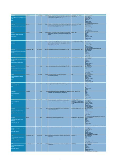
OBSERVATION
CEOS EOHB tables June 2012 web - ceos eo handbook
CEOS EOHB tables June 2012 web - ceos eo handbook
- No tags were found...

Create successful ePaper yourself
Turn your PDF publications into a flip-book with our unique Google optimized e-Paper software.
Mission Status Launch Date EOL Date Applications Instruments Orbit Details & URL<br />
DMSP F-19<br />
Approved Oct 2012 Oct 2017 The long-term meteorological programme of the US Department OLS, SSM/IS, SSM, SSI/ES-3, Type: Sun-synchronous<br />
of Defense (DoD) - with the objective to collect and disseminate SSULI, SSUSI<br />
Altitude: 833 km<br />
Defense Meteorological Satellite Program<br />
worldwide cloud cover data on a daily basis.<br />
Period: 101 mins<br />
F-19<br />
Inclination: 98.7 deg<br />
Repeat cycle:<br />
NOAA<br />
LST:<br />
Longitude (if geo):<br />
Asc/desc: Ascending<br />
URL: dmsp.ngdc.noaa.gov/dmsp.html<br />
DMSP F-20<br />
Approved Jun 2014 Jun 2019 The long-term meteorological programme of the US Department OLS, SSM/IS, SSM, SSI/ES-3, Type: Sun-synchronous<br />
of Defense (DoD) - with the objective to collect and disseminate SSULI, SSUSI<br />
Altitude: 850 km<br />
Defense Meteorological Satellite Program<br />
worldwide cloud cover data on a daily basis.<br />
Period: 101 mins<br />
F-20<br />
Inclination: 98.7 deg<br />
Repeat cycle:<br />
NOAA<br />
LST:<br />
Longitude (if geo):<br />
Asc/desc: Ascending<br />
URL: dmsp.ngdc.noaa.gov/dmsp.html<br />
DSCOVR<br />
Approved Jul 2014 Jul 2016 Measure a combination of solar phenomena and earth climate NISTAR, EPIC<br />
Type: TBD<br />
measurements. Provides 15 min warning for solar storms (CME)<br />
Altitude:<br />
Deep Space Climate Observatory<br />
events.<br />
Period:<br />
Inclination:<br />
NOAA / NASA<br />
Repeat cycle: 1 days<br />
LST:<br />
Longitude (if geo):<br />
Asc/desc:<br />
URL:<br />
EarthCARE<br />
Approved Nov 2015 Nov 2018 To Improve the understanding of atmospheric cloud–aerosol CPR (EarthCARE), ATLID, BBR Type: Sun-synchronous<br />
interactions and of the Earth's radiative balance towards (EarthCARE), MSI (EarthCARE) Altitude: 393 km<br />
enhancing climate and numerical weather prediction models. The<br />
Period:<br />
ESA / JAXA<br />
2 active and 2 passive instruments of EarthCARE make unique<br />
Inclination: 97 deg<br />
data product synergies possible.<br />
Repeat cycle: 25 days<br />
LST:<br />
Longitude (if geo):<br />
Asc/desc: Descending<br />
URL: www.esa.int/export/esaLP/earthcare.html<br />
Elektro-L N1<br />
Currently being flown 20 Jan 2011 Dec 2018 Hydrometeorology, heliogeophysics, climatology, DCS, S&R. MSU-GS, DCS , GGAK-E, S&R Type: Geostationary<br />
Altitude: 36000 km<br />
Geostationary Operational Meteorological<br />
Period:<br />
Satellite - 1<br />
Inclination:<br />
Repeat cycle:<br />
ROSHYDROMET / ROSKOSMOS<br />
LST:<br />
Longitude (if geo): -76<br />
Asc/desc: N/A<br />
URL: planet.iitp.ru<br />
Elektro-L N2<br />
Approved Nov 2012 Nov 2018 Hydrometeorology, heliogeophysics, climatology, DCS, S&R. MSU-GS, DCS , GGAK-E, S&R Type: Geostationary<br />
Altitude: 36000 km<br />
Geostationary Operational Meteorological<br />
Period:<br />
Satellite - 2<br />
Inclination:<br />
Repeat cycle:<br />
ROSHYDROMET / ROSKOSMOS<br />
LST:<br />
Longitude (if geo): -76<br />
Asc/desc: N/A<br />
URL: planet.iitp.ru<br />
Elektro-L N3<br />
Planned 2015 2022 Hydrometeorology, heliogeophysics, climatology, DCS, S&R. MSU-GS, DCS , GGAK-E, S&R Type: Geostationary<br />
Altitude: 36000 km<br />
Geostationary Operational Meteorological<br />
Period:<br />
Satellite - 3<br />
Inclination:<br />
Repeat cycle:<br />
ROSHYDROMET / ROSKOSMOS<br />
LST:<br />
Longitude (if geo): 14.5<br />
Asc/desc: N/A<br />
URL: planet.iitp.ru<br />
EnMAP<br />
Approved Dec 2015 Dec 2020 Hyperspectral imaging, land surface, geological and<br />
HSI<br />
Type: Sun-synchronous<br />
environmental investigation.<br />
Altitude: 650 km<br />
Environmental Mapping & Analysis<br />
Period: 97.5 mins<br />
Program<br />
Inclination:<br />
Repeat cycle: 21 days<br />
DLR<br />
LST: 11:00<br />
Longitude (if geo):<br />
Asc/desc: Descending<br />
URL: www.enmap.org/<br />
Environsat-1<br />
Considered 2013 2017 Monitoring of greenhouse gases, aerosols and other atmospheric HRSS-1, HRVS-1A/-1B<br />
Type:<br />
trace gases which are responsible for global warming.<br />
Altitude:<br />
Environmental Satellite - 1<br />
Period:<br />
Inclination:<br />
ISRO<br />
Repeat cycle:<br />
LST:<br />
Longitude (if geo):<br />
Asc/desc:<br />
URL:<br />
Environsat-2<br />
Considered 2016 2020 Monitoring of greenhouse gases, aerosols and other atmospheric HRSS-1, HRVS-1A/-1B<br />
Type:<br />
trace gases which are responsible for global warming.<br />
Altitude:<br />
Environmental Satellite - 2<br />
Period:<br />
Inclination:<br />
ISRO<br />
Repeat cycle:<br />
LST:<br />
Longitude (if geo):<br />
Asc/desc:<br />
URL:<br />
Envisat<br />
Currently being flown 01 Mar 2002 Dec 2013 Physical oceanography, land surface, ice and snow, atmospheric DORIS-NG, MWR, ASAR (image Type: Sun-synchronous<br />
chemistry, atmospheric dynamics/water and energy cycles. mode), ASAR (wave mode), Altitude: 782 km<br />
Environmental Satellite<br />
ENVISAT Comms, MERIS, MIPAS, Period: 100.5 mins<br />
ASAR, GOMOS, SCIAMACHY, RA-2, Inclination: 98.52 deg<br />
ESA<br />
AATSR<br />
Repeat cycle: 35 days<br />
LST: 10:30<br />
Longitude (if geo):<br />
Asc/desc: Descending<br />
URL: envisat.esa.int/<br />
EPS-SG-a<br />
Planned 2019 2027 Meteorology, climatology. EPS-SG-a carries the Sentinel-5 ATMS, METimage, IASI-NG, 3MI, RO Type: Sun-synchronous<br />
mission. 3 satellites (TBC).<br />
Altitude:<br />
EUMETSAT Polar System, second<br />
Period:<br />
generation<br />
Inclination:<br />
Repeat cycle: 29 days<br />
EUMETSAT / NOAA / DLR / EC / CNES /<br />
LST:<br />
ESA<br />
Longitude (if geo):<br />
Asc/desc: N/A<br />
URL:<br />
www.eumetsat.int/Home/Main/Satellites/index.htm?l=en?<br />
EPS-SG-b<br />
Planned 2020 2028 Meteorology, climatology. 2 satellites (TBC). RO, MWI-Precip, MWI-Cloud, SCA Type: Sun-synchronous<br />
Altitude:<br />
EUMETSAT Polar System, second<br />
Period:<br />
generation<br />
Inclination:<br />
Repeat cycle:<br />
EUMETSAT / EC / ESA<br />
LST:<br />
Longitude (if geo):<br />
Asc/desc:<br />
URL:<br />
www.eumetsat.int/Home/Main/Satellites/index.htm?l=en?<br />
FY-1D<br />
Currently being flown 15 May 2002 Dec 2012 Meteorology, environmental monitoring. MVISR (10 channels) Type: Sun-synchronous<br />
Altitude: 863 km<br />
FY-1D Polar-orbiting Meteorological<br />
Period: 102.3 mins<br />
Satellite<br />
Inclination: 98.8 deg<br />
Repeat cycle:<br />
NSMC-CMA / NRSCC<br />
LST: 9:00<br />
Longitude (if geo):<br />
Asc/desc: Descending<br />
URL: fy3.satellite.cma.gov.cn/arssen/<br />
FY-2D<br />
Currently being flown 08 Dec 2006 Dec 2012 Meteorology and environmental monitoring; data collection and IVISSR (FY-2)<br />
Type: Geostationary<br />
redistribution.<br />
Altitude: 36000 km<br />
FY-2D Geostationary Meteorological<br />
Period:<br />
Satellite<br />
Inclination:<br />
Repeat cycle:<br />
NSMC-CMA / NRSCC<br />
LST:<br />
Longitude (if geo): -86.5<br />
Asc/desc: N/A<br />
URL: fy3.satellite.cma.gov.cn/arssen/<br />
FY-2E<br />
Currently being flown 26 Dec 2008 Dec 2012 Meteorology and environmental monitoring; data collection and IVISSR (FY-2)<br />
Type: Geostationary<br />
redistribution.<br />
Altitude: 36000 km<br />
FY-2E Geostationary Meteorological<br />
Period:<br />
Satellite<br />
Inclination:<br />
Repeat cycle:<br />
NSMC-CMA / NRSCC<br />
LST:<br />
Longitude (if geo): -105<br />
Asc/desc: N/A<br />
URL: fy3.satellite.cma.gov.cn/arssen/<br />
7


