OBSERVATION
CEOS EOHB tables June 2012 web - ceos eo handbook
CEOS EOHB tables June 2012 web - ceos eo handbook
- No tags were found...
Create successful ePaper yourself
Turn your PDF publications into a flip-book with our unique Google optimized e-Paper software.
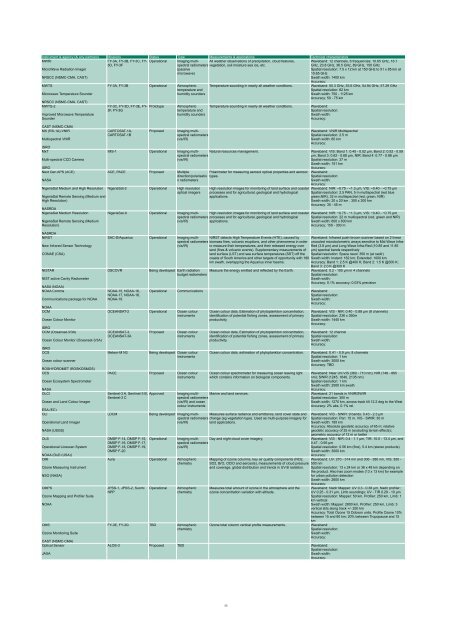
Instrument & agency (& any partners) Missions Status Type Measurements & applications Technical characteristics<br />
MWRI<br />
FY-3A, FY-3B, FY-3C, FY- Operational Imaging multispectral<br />
All weather observations of precipitation, cloud features, Waveband: 12 channels, 6 frequencies: 10.65 GHz, 18.7<br />
3D, FY-3F<br />
radiometers vegetation, soil moisture sea ice, etc.<br />
GHz, 23.8 GHz, 36.5 GHz, 89 GHz, 150 GHz<br />
MicroWave Radiation Imager<br />
NRSCC (NSMC-CMA, CAST)<br />
(passive<br />
microwave)<br />
Spatial resolution: 7.5 x 12 km at 150 GHz to 51 x 85 km at<br />
10.65 GHz<br />
Swath width: 1400 km<br />
Accuracy:<br />
MWTS<br />
Microwave Temperature Sounder<br />
NRSCC (NSMC-CMA, CAST)<br />
MWTS-2<br />
Improved Microwave Temperature<br />
Sounder<br />
CAST (NSMC-CMA)<br />
MX (RS-1A)-VNIR<br />
Multispectral VNIR<br />
ISRO<br />
MxT<br />
Multi-spectral CCD Camera<br />
ISRO<br />
Next Gen APS (ACE)<br />
NASA<br />
NigeriaSat Medium and High Resolution<br />
NigeriaSat Remote Sensing (Medium and<br />
High Resolution)<br />
NASRDA<br />
NigeriaSat Medium Resolution<br />
NigeriaSat Remote Sensing (Medium<br />
Resolution)<br />
FY-3A, FY-3B Operational Atmospheric<br />
temperature and<br />
humidity sounders<br />
FY-3C, FY-3D, FY-3E, FY-<br />
3F, FY-3G<br />
CARTOSAT-1A,<br />
CARTOSAT-1B<br />
Prototype<br />
Proposed<br />
Atmospheric<br />
temperature and<br />
humidity sounders<br />
Imaging multispectral<br />
radiometers<br />
(vis/IR)<br />
IMS-1 Operational Imaging multispectral<br />
radiometers<br />
(vis/IR)<br />
Temperature sounding in nearly all weather conditions.<br />
Temperature sounding in nearly all weather conditions.<br />
Waveband: 50.3 GHz, 53.6 GHz, 54.94 GHz, 57.29 GHz<br />
Spatial resolution: 62 km<br />
Swath width: 750 - 1125 km<br />
Accuracy: 50 - 75 km<br />
Waveband:<br />
Spatial resolution:<br />
Swath width:<br />
Accuracy:<br />
Waveband: VNIR Multispectral<br />
Spatial resolution: 2.5 m<br />
Swath width: 60 km<br />
Accuracy:<br />
Natural resources management. Waveband: VIS: Band 1: 0.45 - 0.52 µm, Band 2: 0.52 - 0.59<br />
µm, Band 3: 0.62 - 0.68 µm, NIR: Band 4: 0.77 - 0.86 µm<br />
Spatial resolution: 37 m<br />
Swath width: 151 km<br />
Accuracy:<br />
ACE, PACE Proposed Multiple<br />
Polarimeter for measuring aerosol optical properties and aerosol<br />
direction/polarisatio types.<br />
n radiometers<br />
NigeriaSat-2 Operational High resolution<br />
optical imagers<br />
High resolution images for monitoring of land surface and coastal<br />
processes and for agricultural, geological and hydrological<br />
applications.<br />
Waveband:<br />
Spatial resolution:<br />
Swath width:<br />
Accuracy:<br />
Waveband: NIR: ~0.75 - ~1.3 µm, VIS: ~0.40 - ~0.75 µm<br />
Spatial resolution: 2.5 PAN, 5 m multispectral (red blue<br />
green,NIR), 32 m multispectral (red, green, NIR)<br />
Swath width: 20 x 20 km , 300 x 300 km<br />
Accuracy: 35 - 45 m<br />
NigeriaSat-X Operational Imaging multispectral<br />
High resolution images for monitoring of land surface and coastal Waveband: NIR: ~0.75 - ~1.3 µm, VIS: ~0.40 - ~0.75 µm<br />
radiometers processes and for agricultural, geological and hydrological Spatial resolution: 22 m multispectral (red, green and NIR)<br />
(vis/IR)<br />
applications.<br />
Swath width: 600 x 600 km<br />
Accuracy: 150 - 300 m<br />
NASRDA<br />
NIRST<br />
New Infrared Sensor Technology<br />
CONAE (CSA)<br />
NISTAR<br />
NIST active Cavity Radiometer<br />
NASA (NOAA)<br />
NOAA Comms<br />
Communications package for NOAA<br />
NOAA<br />
OCM<br />
Ocean Colour Monitor<br />
ISRO<br />
OCM (Oceansat-3/3A)<br />
Ocean Colour Monitor (Oceansat-3/3A)<br />
ISRO<br />
OCS<br />
Ocean colour scanner<br />
ROSHYDROMET (ROSKOSMOS)<br />
OES<br />
Ocean Ecosystem Spectrometer<br />
NASA<br />
OLCI<br />
Ocean and Land Colour Imager<br />
ESA (EC)<br />
OLI<br />
Operational Land Imager<br />
NASA (USGS)<br />
OLS<br />
Operational Linescan System<br />
NOAA (DoD (USA))<br />
OMI<br />
Ozone Measuring Instrument<br />
NSO (NASA)<br />
OMPS<br />
Ozone Mapping and Profiler Suite<br />
NOAA<br />
OMS<br />
Ozone Monitoring Suite<br />
CAST (NSMC-CMA)<br />
Optical Sensor<br />
JAXA<br />
DSCOVR<br />
NOAA-15, NOAA-16,<br />
NOAA-17, NOAA-18,<br />
NOAA-19<br />
SAC-D/Aquarius Operational Imaging multispectral<br />
radiometers<br />
(vis/IR)<br />
NIRST detects High Temperature Events (HTE), caused by<br />
biomass fires, volcanic eruptions, and other phenomena in order<br />
to measure their temperatures, and their released energy over<br />
land (fires & volcanic events). Supplementary measurements of<br />
land surface (LST) and sea surface temperatures (SST) off the<br />
coasts of South America and other targets of opportunity with 180<br />
km swath, overlapping the Aquarius inner beams.<br />
Being developed Earth radiation Measure the energy emitted and reflected by the Earth.<br />
budget radiometers<br />
Operational Communications Waveband:<br />
Spatial resolution:<br />
Swath width:<br />
Accuracy:<br />
OCEANSAT-2 Operational Ocean colour<br />
instruments<br />
OCEANSAT-3,<br />
OCEANSAT-3A<br />
Meteor-M N3<br />
Proposed<br />
Ocean colour<br />
instruments<br />
Being developed Ocean colour<br />
instruments<br />
PACE Proposed Ocean colour<br />
instruments<br />
Sentinel-3 A, Sentinel-3 B, Approved<br />
Sentinel-3 C<br />
LDCM<br />
DMSP F-14, DMSP F-15, Operational<br />
DMSP F-16, DMSP F-17,<br />
DMSP F-18, DMSP F-19,<br />
DMSP F-20<br />
Ocean colour data, Estimation of phytoplankton concentration,<br />
identification of potential fishing zones, assessment of primary<br />
productivity.<br />
Ocean colour data, Estimation of phytoplankton concentration,<br />
identification of potential fishing zones, assessment of primary<br />
productivity.<br />
Ocean colour data, estimation of phytoplankton concentration.<br />
Ocean colour spectrometer for measuring ocean leaving light<br />
which contains information on biological components.<br />
Imaging multispectral<br />
radiometers<br />
Marine and land services.<br />
(vis/IR) and ocean<br />
colour instruments<br />
Being developed Imaging multispectral<br />
radiometers change (eg vegetation type). Used as multi-purpose imagery for<br />
Measures surface radiance and emittance, land cover state and<br />
(vis/IR)<br />
land applications.<br />
Aura Operational Atmospheric<br />
chemistry<br />
JPSS-1, JPSS-2, Suomi<br />
NPP<br />
Operational<br />
Imaging multispectral<br />
radiometers<br />
Day and night cloud cover imagery.<br />
(vis/IR)<br />
Atmospheric<br />
chemistry<br />
FY-3E, FY-3G TBD Atmospheric<br />
chemistry<br />
Waveband: Infrared push-broom scanner based on 2 linear<br />
uncooled microbolometric arrays sensitive to Mid-Wave Infra-<br />
Red (3.8 µm) and Long-Wave Infra-Red (10.85 and 11.85<br />
µm) spectral bands respectively<br />
Spatial resolution: Space resol: 350 m (at nadir)<br />
Swath width: Instant: 182 km; Extended: 1000 km<br />
Accuracy: Band 1: 2.5 K @400 K; Band 2: 1.5 K @300 K;<br />
Band 3: 2.0 K @300 K<br />
Waveband: 0.2 - 100 µm in 4 channels<br />
Spatial resolution:<br />
Swath width:<br />
Accuracy: 0.1% accuracy; 0.03% precision<br />
Waveband: VIS - NIR: 0.40 - 0.88 µm (8 channels)<br />
Spatial resolution: 236 x 360m<br />
Swath width: 1440 km<br />
Accuracy:<br />
Waveband: 12 channel<br />
Spatial resolution:<br />
Swath width:<br />
Accuracy:<br />
Waveband: 0.41 - 0.9 µm, 8 channels<br />
Spatial resolution: 1 km<br />
Swath width: 3000 km<br />
Accuracy: TBD<br />
Waveband: Near UV-VIS (360 - 710 nm); NIR (748 - 865<br />
nm); SWIR (1245, 1640, 2135 nm)<br />
Spatial resolution: 1 km<br />
Swath width: 2500 km swath<br />
Accuracy:<br />
Waveband: 21 bands in VNIR/SWIR<br />
Spatial resolution: 300 m<br />
Swath width: 1270 km, across-track tilt 12.2 deg to the West<br />
Accuracy: 2% abs, 0.1% rel.<br />
Waveband: VIS - SWIR: 9 bands: 0.43 - 2.3 µm<br />
Spatial resolution: Pan: 15 m, VIS - SWIR: 30 m<br />
Swath width: 185 km<br />
Accuracy: Absolute geodetic accuracy of 65 m; relative<br />
geodetic accuracy of 25 m (excluding terrain effects);<br />
geometric accuracy of 12 m or better<br />
Waveband: VIS - NIR: 0.4 - 1.1 µm, TIR: 10.0 - 13.4 µm, and<br />
0.47 - 0.95 µm<br />
Spatial resolution: 0.56 km (fine), 5.4 km (stereo products)<br />
Swath width: 3000 km<br />
Accuracy:<br />
Mapping of ozone columns, key air quality components (NO2, Waveband: UV: 270 - 314 nm and 306 - 380 nm, VIS: 350 -<br />
SO2, BrO, OClO and aerosols), measurements of cloud pressure 500 nm<br />
and coverage, global distribution and trends in UV-B radiation. Spatial resolution: 13 x 24 km or 36 x 48 km depending on<br />
the product. Also has zoom modes (13 x 13 km) for example<br />
for urban pollution detection<br />
Swath width: 2600 km<br />
Accuracy:<br />
Measures total amount of ozone in the atmosphere and the<br />
ozone concentration variation with altitude.<br />
Ozone total column vertical profile measurements.<br />
ALOS-3 Proposed TBD Waveband:<br />
Spatial resolution:<br />
Swath width:<br />
Accuracy:<br />
Waveband: Nadir Mapper: UV 0.3 - 0.38 µm, Nadir profiler:<br />
UV 0.25 - 0.31 µm, Limb soundings: UV - TIR 0.29 - 10 µm<br />
Spatial resolution: Mapper: 50 km, Profiler: 250 km, Limb: 1<br />
km vertical<br />
Swath width: Mapper: 2800 km, Profiler: 250 km, Limb: 3<br />
vertical slits along track +/- 250 km<br />
Accuracy: Total Ozone 15 Dobson units. Profile Ozone 10%<br />
between 15 and 60 km; 20% between Tropopause and 15<br />
km<br />
Waveband:<br />
Spatial resolution:<br />
Swath width:<br />
Accuracy:<br />
33


