OBSERVATION
CEOS EOHB tables June 2012 web - ceos eo handbook
CEOS EOHB tables June 2012 web - ceos eo handbook
- No tags were found...
Create successful ePaper yourself
Turn your PDF publications into a flip-book with our unique Google optimized e-Paper software.
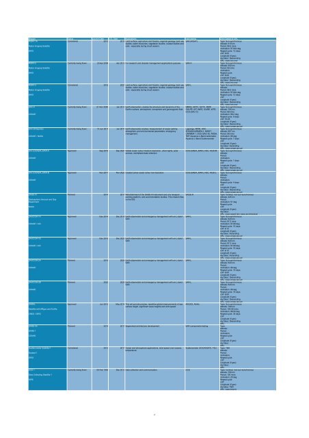
Mission Status Launch Date EOL Date Applications Instruments Orbit Details & URL<br />
RISAT-1A<br />
Considered 2015 2019 Land surface, agriculture and forestry, regional geology, land use SAR (RISAT)<br />
Type: Sun-synchronous<br />
studies, water resources, vegetation studies, coastal studies and<br />
Altitude: 610 km<br />
Radar Imaging Satellite<br />
soils - especially during cloud season.<br />
Period: 96.5 mins<br />
Inclination: 97.844 deg<br />
ISRO<br />
Repeat cycle: 12 days<br />
LST: 6:00<br />
Longitude (if geo):<br />
Asc/desc: Descending<br />
URL: www.isro.org/<br />
RISAT-2<br />
Currently being flown 20 Apr 2009 Apr 2013 For research and disaster management applications purpose. SAR-X Type: Sun-synchronous<br />
Altitude: 550 km<br />
Radar Imaging Satellite<br />
Period: 90 mins<br />
Inclination:<br />
ISRO<br />
Repeat cycle:<br />
LST: 6:00<br />
Longitude (if geo):<br />
Asc/desc: Descending<br />
URL: www.isro.org/<br />
RISAT-3<br />
Considered 2016 2021 Land surface, agriculture and forestry, regional geology, land use SAR-L<br />
Type: Sun-synchronous<br />
studies, water resources, vegetation studies, coastal studies and<br />
Altitude:<br />
Radar Imaging Satellite<br />
soils - especially during cloud season.<br />
Period: 96.5 mins<br />
Inclination: 97.844 deg<br />
ISRO<br />
Repeat cycle: 12 days<br />
LST:<br />
Longitude (if geo):<br />
Asc/desc: Descending<br />
URL: www.isro.org/<br />
SAC-C<br />
Currently being flown 21 Nov 2000 Jan 2013 Earth observation, studies the structure and dynamics of the MMRS, HRTC, HSTC, MMP, Type: Sun-synchronous<br />
Earth’s surface, atmosphere, ionosphere and geomagnetic field. GOLPE, IST, INES, ICARE, WTE, Altitude: 705 km<br />
DCS (SAC-C)<br />
Period: 98 mins<br />
CONAE<br />
Inclination: 98.2 deg<br />
Repeat cycle: 9 days<br />
LST: 10:25<br />
Longitude (if geo):<br />
Asc/desc: Descending<br />
URL: www.conae.gov.ar/<br />
SAC-D/Aquarius<br />
Currently being flown 10 Jun 2011 Jun 2017 Earth observation studies; measurement of ocean salinity; Lagrange, MWR, HSC,<br />
Type: Sun-synchronous<br />
atmospheric and environmental parameters, emergency SODAD/CARMEN-1, NIRST, Altitude: 657 km<br />
management.<br />
CARMEN-1, DCS (SAC-D), ROSA, Period: 98 mins<br />
CONAE / NASA<br />
TDP, Aquarius L-Band radiometer, Inclination: 98 deg<br />
Aquarius L-Band Scatterometer Repeat cycle: 7 days<br />
LST:<br />
Longitude (if geo):<br />
Asc/desc: Ascending<br />
URL: www.conae.gov.ar/<br />
SAC-E/SABIA_MAR-A<br />
Approved Sep 2016 Sep 2021 Global ocean colour medium resolution, urban lights, polar DCS (SABIA_MAR), HSC, MUS-M Type: Sun-synchronous<br />
auroras, centralised data collection.<br />
Altitude:<br />
Period:<br />
CONAE<br />
Inclination:<br />
Repeat cycle: 1 days<br />
LST:<br />
Longitude (if geo):<br />
Asc/desc: Descending<br />
URL: www.conae.gov.ar/<br />
SAC-E/SABIA_MAR-B<br />
Approved Nov 2017 Nov 2022 Coastal zones ocean colour low resolution. DCS (SABIA_MAR), HSC, MUS-L Type: Sun-synchronous<br />
Altitude:<br />
Period:<br />
CONAE<br />
Inclination:<br />
Repeat cycle: 4 days<br />
LST:<br />
Longitude (if geo):<br />
Asc/desc: Descending<br />
URL: www.conae.gov.ar/<br />
SAGE-III<br />
Planned 2014 2017 Refurbishment of the SAGE-III instrument and of a hexapod SAGE-III<br />
Type: Inclined, non-sun-synchronous<br />
pointing platform, and accommodation studies. This mission flies<br />
Altitude: 425 km<br />
Stratospheric Aerosol and Gas<br />
on the ISS.<br />
Period:<br />
Experiment<br />
Inclination: 51 deg<br />
Repeat cycle:<br />
NASA<br />
LST:<br />
Longitude (if geo):<br />
Asc/desc:<br />
URL: www-sage3.larc.nasa.gov/missions/<br />
SAOCOM 1A<br />
Approved Dec 2014 Dec 2019 Earth observation and emergency management with an L-band SAR-L<br />
Type: Sun-synchronous<br />
SAR.<br />
Altitude: 620 km<br />
Period: 97.2 mins<br />
CONAE / ASI<br />
Inclination: 97.89 deg<br />
Repeat cycle: 16 days<br />
LST: 6:12<br />
Longitude (if geo):<br />
Asc/desc: Ascending<br />
URL: www.conae.gov.ar/<br />
SAOCOM 1B<br />
Approved Dec 2015 Dec 2020 Earth observation and emergency management with an L-band SAR-L<br />
Type: Sun-synchronous<br />
SAR.<br />
Altitude: 620 km<br />
Period: 97.2 mins<br />
CONAE / ASI<br />
Inclination: 97.89 deg<br />
Repeat cycle: 16 days<br />
LST: 6:12<br />
Longitude (if geo):<br />
Asc/desc: Ascending<br />
URL: www.conae.gov.ar/<br />
SAOCOM-2A<br />
Planned 2019 2024 Earth observation and emergency management with an L-band SAR-L<br />
Type: Sun-synchronous<br />
SAR.<br />
Altitude: 620 km<br />
Period:<br />
CONAE<br />
Inclination: 98 deg<br />
Repeat cycle: 16 days<br />
LST: 6:00<br />
Longitude (if geo):<br />
Asc/desc: Descending<br />
URL: www.conae.gov.ar/<br />
SAOCOM-2B<br />
Planned 2020 2025 Earth observation and emergency management with an L-band SAR-L<br />
Type: Sun-synchronous<br />
SAR.<br />
Altitude: 620 km<br />
Period:<br />
CONAE<br />
Inclination: 98 deg<br />
Repeat cycle: 16 days<br />
LST: 6:00<br />
Longitude (if geo):<br />
Asc/desc: Descending<br />
URL: www.conae.gov.ar/<br />
SARAL<br />
Approved Jun 2012 May 2014 This will provide precise, repetitive global measurements of sea ARGOS, AltiKa<br />
Type: Sun-synchronous<br />
surface height, significant wave heights and wind speed.<br />
Altitude: 799 km<br />
Satellite with ARgos and ALtiKa<br />
Period: 100.59 mins<br />
Inclination: 98.55 deg<br />
CNES / ISRO<br />
Repeat cycle: 35 days<br />
LST:<br />
Longitude (if geo):<br />
Asc/desc: Descending<br />
URL:<br />
SARE-1B<br />
Planned 2014 2017 Segmented architecture development. SAR components testing Type:<br />
Altitude:<br />
SARE-1<br />
Period:<br />
Inclination:<br />
CONAE<br />
Repeat cycle:<br />
LST:<br />
Longitude (if geo):<br />
Asc/desc:<br />
URL:<br />
Scatterometer Satellite-1<br />
Considered 2013 2017 Ocean and atmosphere applications, wind speed over oceans, Scatterometer (OCEANSAT), TSU Type: TBD<br />
temperature.<br />
Altitude:<br />
Scatsat-1<br />
Period:<br />
Inclination:<br />
ISRO<br />
Repeat cycle:<br />
LST:<br />
Longitude (if geo):<br />
Asc/desc:<br />
URL:<br />
SCD-1<br />
Currently being flown 09 Feb 1993 Dec 2012 Data collection and communication. DCS Type: Inclined, non-sun-synchronous<br />
Altitude: 750 km<br />
Data Collecting Satellite 1<br />
Period: 100 mins<br />
Inclination: 25 deg<br />
INPE<br />
Repeat cycle:<br />
LST:<br />
Longitude (if geo):<br />
Asc/desc: TBD<br />
URL: www.inpe.br<br />
17


