OBSERVATION
CEOS EOHB tables June 2012 web - ceos eo handbook
CEOS EOHB tables June 2012 web - ceos eo handbook
- No tags were found...
Create successful ePaper yourself
Turn your PDF publications into a flip-book with our unique Google optimized e-Paper software.
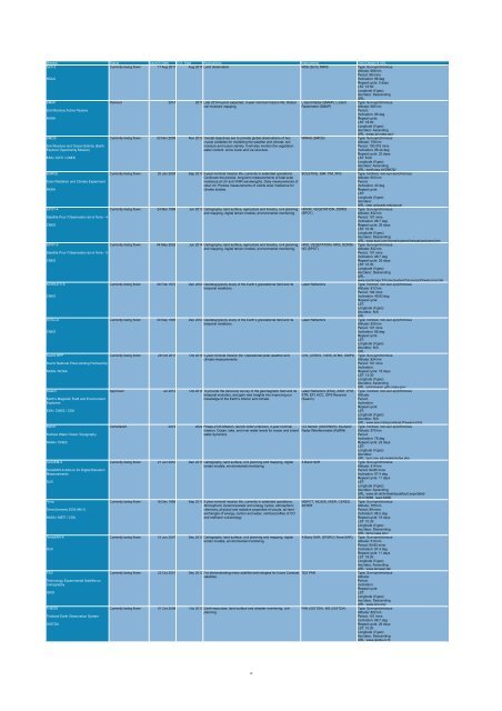
Mission Status Launch Date EOL Date Applications Instruments Orbit Details & URL<br />
Sich-2<br />
Currently being flown 17 Aug 2011 Aug 2015 Land observation. MSS (Sich), MIRS Type: Sun-synchronous<br />
Altitude: 668 km<br />
Period: 98 mins<br />
NSAU<br />
Inclination: 98 deg<br />
Repeat cycle: 5 days<br />
LST: 10:50<br />
Longitude (if geo):<br />
Asc/desc: Descending<br />
URL:<br />
SMAP<br />
Planned 2014 2017 Late 2014 launch expected, 3-year nominal mission life. Global L-band Radar (SMAP), L-band Type: Sun-synchronous<br />
soil moisture mapping.<br />
Radiometer (SMAP)<br />
Altitude: 685 km<br />
Soil Moisture Active Passive<br />
Period:<br />
Inclination: 98 deg<br />
NASA<br />
Repeat cycle:<br />
LST: 18:00<br />
Longitude (if geo):<br />
Asc/desc: Ascending<br />
URL: smap.jpl.nasa.gov/<br />
SMOS<br />
Currently being flown 02 Nov 2009 Nov 2012 Overall objectives are to provide global observations of two MIRAS (SMOS)<br />
Type: Sun-synchronous<br />
crucial variables for modelling the weather and climate, soil<br />
Altitude: 758 km<br />
Soil Moisture and Ocean Salinity (Earth<br />
moisture and ocean salinity. It will also monitor the vegetation<br />
Period: 100.075 mins<br />
Explorer Opportunity Mission)<br />
water content, snow cover and ice structure.<br />
Inclination: 98.44 deg<br />
Repeat cycle: 23 days<br />
ESA / CDTI / CNES<br />
LST: 6:00<br />
Longitude (if geo):<br />
Asc/desc: Ascending<br />
URL: earth.esa.int/SMOS/<br />
SORCE<br />
Currently being flown 25 Jan 2003 Sep 2013 5-year nominal mission life, currently in extended operations. SOLSTICE, SIM, TIM, XPS Type: Inclined, non-sun-synchronous<br />
Continues the precise, long-term measurements of total solar<br />
Altitude: 600 km<br />
Solar Radiation and Climate Experiment<br />
irradiance at UV and VNIR wavelengths. Daily measurements of<br />
Period:<br />
solar UV. Precise measurements of visible solar irradiance for<br />
Inclination: 40 deg<br />
NASA<br />
climate studies.<br />
Repeat cycle:<br />
LST:<br />
Longitude (if geo):<br />
Asc/desc:<br />
URL: lasp.colorado.edu/sorce/<br />
SPOT-4<br />
Currently being flown 24 Mar 1998 Jun 2013 Cartography, land surface, agriculture and forestry, civil planning HRVIR, VEGETATION, DORIS Type: Sun-synchronous<br />
and mapping, digital terrain models, environmental monitoring. (SPOT)<br />
Altitude: 832 km<br />
Satellite Pour l'Observation de la Terre - 4<br />
Period: 101 mins<br />
Inclination: 98.7 deg<br />
CNES<br />
Repeat cycle: 26 days<br />
LST: 10:30<br />
Longitude (if geo):<br />
Asc/desc: Descending<br />
URL: www.spot.com/home/system/introsat/welcome.htm<br />
SPOT-5<br />
Currently being flown 04 May 2002 Jun 2014 Cartography, land surface, agriculture and forestry, civil planning HRG, VEGETATION, HRS, DORIS- Type: Sun-synchronous<br />
and mapping, digital terrain models, environmental monitoring. NG (SPOT)<br />
Altitude: 832 km<br />
Satellite Pour l'Observation de la Terre - 5<br />
Period: 101 mins<br />
Inclination: 98.7 deg<br />
CNES<br />
Repeat cycle: 26 days<br />
LST: 10:30<br />
Longitude (if geo):<br />
Asc/desc: Descending<br />
URL:<br />
www.spotimage.fr/home/system/future/spot5/welcome.htm<br />
STARLETTE<br />
Currently being flown 06 Feb 1975 Dec 2050 Geodesy/gravity study of the Earth’s gravitational field and its Laser Reflectors<br />
Type: Inclined, non-sun-synchronous<br />
temporal variations.<br />
Altitude: 812 km<br />
Period: 104 mins<br />
CNES<br />
Inclination: 49.83 deg<br />
Repeat cycle:<br />
LST:<br />
Longitude (if geo):<br />
Asc/desc: N/A<br />
URL:<br />
STELLA<br />
Currently being flown 30 Sep 1993 Dec 2050 Geodesy/gravity study of the Earth’s gravitational field and its Laser Reflectors<br />
Type: Inclined, non-sun-synchronous<br />
temporal variations.<br />
Altitude: 830 km<br />
Period: 101 mins<br />
CNES<br />
Inclination: 98 deg<br />
Repeat cycle:<br />
LST:<br />
Longitude (if geo):<br />
Asc/desc: N/A<br />
URL:<br />
Suomi NPP<br />
Currently being flown 28 Oct 2011 Oct 2016 5-year nominal mission life. Operational polar weather and CrIS, CERES, VIIRS, ATMS, OMPS Type: Sun-synchronous<br />
climate measurements.<br />
Altitude: 824 km<br />
Suomi National Polar-orbiting Partnership<br />
Period: 101 mins<br />
Inclination:<br />
NASA / NOAA<br />
Repeat cycle: 16 days<br />
LST: 13:30<br />
Longitude (if geo):<br />
Asc/desc: Ascending<br />
URL: jointmission.gsfc.nasa.gov/<br />
Swarm<br />
Approved Jul 2012 Oct 2016 To provide the best ever survey of the geomagnetic field and its Laser Reflectors (ESA), ASM, VFM, Type: Inclined, non-sun-synchronous<br />
temporal evolution, and gain new insights into improving our STR, EFI, ACC, GPS Receiver Altitude:<br />
Earth's Magnetic Field and Environment<br />
knowledge of the Earth’s interior and climate.<br />
(Swarm)<br />
Period:<br />
Explorers<br />
Inclination:<br />
Repeat cycle:<br />
ESA / CNES / CSA<br />
LST:<br />
Longitude (if geo):<br />
Asc/desc: N/A<br />
URL: www.esa.int/export/esaLP/swarm.html<br />
SWOT<br />
Considered 2019 2022 Phase-2 DS Mission, launch order unknown, 3-year nominal CO Sensor (ASCENDS), Ka-band Type: Inclined, non-sun-synchronous<br />
mission. Ocean, lake, and river water levels for ocean and inland Radar INterferometer (KaRIN) Altitude: 970 km<br />
Surface Water Ocean Topography<br />
water dynamics.<br />
Period:<br />
Inclination: 78 deg<br />
NASA / CNES<br />
Repeat cycle: 22 days<br />
LST:<br />
Longitude (if geo):<br />
Asc/desc:<br />
URL: bprc.osu.edu/water/index.php<br />
TanDEM-X<br />
Currently being flown 21 Jun 2010 Dec 2015 Cartography, land surface, civil planning and mapping, digital X-Band SAR<br />
Type: Sun-synchronous<br />
terrain models, environmental monitoring.<br />
Altitude: 514 km<br />
TerraSAR-X Add-on for Digital Elevation<br />
Period: 94.85 mins<br />
Measurements<br />
Inclination: 97.4 deg<br />
Repeat cycle: 11 days<br />
DLR<br />
LST:<br />
Longitude (if geo):<br />
Asc/desc: Ascending<br />
URL: www.dlr.de/hr/desktopdefault.aspx/tabid-<br />
2317/3669_read-5488/<br />
Terra<br />
Currently being flown 18 Dec 1999 Sep 2013 6-year nominal mission life, currently in extended operations. MOPITT, MODIS, MISR, CERES, Type: Sun-synchronous<br />
Atmospheric dynamics/water and energy cycles, atmospheric ASTER<br />
Altitude: 705 km<br />
Terra (formerly EOS AM-1)<br />
chemistry, physical and radiative properties of clouds, air-land<br />
Period: 99 mins<br />
exchanges of energy, carbon and water, vertical profiles of CO<br />
Inclination: 98.2 deg<br />
NASA / METI / CSA<br />
and methane vulcanology.<br />
Repeat cycle: 16 days<br />
LST: 10:30<br />
Longitude (if geo):<br />
Asc/desc: Descending<br />
URL: terra.nasa.gov/<br />
TerraSAR-X<br />
Currently being flown 15 Jun 2007 Dec 2013 Cartography, land surface, civil planning and mapping, digital X-Band SAR, GPSRO (Terra-SAR) Type: Sun-synchronous<br />
terrain models, environmental monitoring.<br />
Altitude: 514 km<br />
Period: 94.85 mins<br />
DLR<br />
Inclination: 97.4 deg<br />
Repeat cycle: 11 days<br />
LST: 18:00<br />
Longitude (if geo):<br />
Asc/desc: Ascending<br />
URL: www.terrasar.de/<br />
TES<br />
Currently being flown 22 Oct 2001 Dec 2012 For demonstrating many satellite technologies for future Cartosat TES PAN<br />
Type: Sun-synchronous<br />
satellites.<br />
Altitude:<br />
Technology Experimental Satellite on<br />
Period:<br />
Cartography<br />
Inclination:<br />
Repeat cycle:<br />
ISRO<br />
LST:<br />
Longitude (if geo):<br />
Asc/desc: Descending<br />
URL: www.isro.org/<br />
THEOS<br />
Currently being flown 01 Oct 2008 Oct 2013 Earth resources, land surface and disaster monitoring, civil PAN (GISTDA), MS (GISTDA) Type: Sun-synchronous<br />
planning.<br />
Altitude: 822 km<br />
Thailand Earth Observation System<br />
Period: 101 mins<br />
Inclination: 98.7 deg<br />
GISTDA<br />
Repeat cycle: 26 days<br />
LST: 10:00<br />
Longitude (if geo):<br />
Asc/desc: Descending<br />
URL: www.gistda.or.th<br />
19


