

OBSERVATION
CEOS EOHB tables June 2012 web - ceos eo handbook
CEOS EOHB tables June 2012 web - ceos eo handbook
- No tags were found...

Create successful ePaper yourself
Turn your PDF publications into a flip-book with our unique Google optimized e-Paper software.
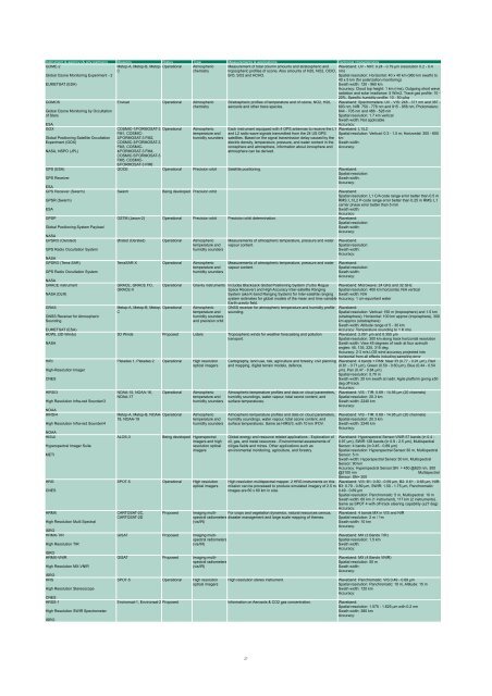
Instrument & agency (& any partners) Missions Status Type Measurements & applications Technical characteristics<br />
GOME-2<br />
Metop-A, Metop-B, Metop- Operational Atmospheric<br />
C<br />
chemistry<br />
Global Ozone Monitoring Experiment - 2<br />
EUMETSAT (ESA)<br />
GOMOS<br />
Global Ozone Monitoring by Occultation<br />
of Stars<br />
ESA<br />
GOX<br />
Global Positioning Satellite Occultation<br />
Experiment (GOX)<br />
NASA, NSPO (JPL)<br />
GPS (ESA)<br />
GPS Receiver<br />
ESA<br />
GPS Receiver (Swarm)<br />
GPSR (Swarm)<br />
ESA<br />
GPSP<br />
Global Positioning System Payload<br />
NASA<br />
GPSRO (Oersted)<br />
GPS Radio Occultation System<br />
NASA<br />
GPSRO (Terra-SAR)<br />
GPS Radio Occultation System<br />
NASA<br />
GRACE instrument<br />
NASA (DLR)<br />
GRAS<br />
GNSS Receiver for Atmospheric<br />
Sounding<br />
EUMETSAT (ESA)<br />
HDWL (3D Winds)<br />
NASA<br />
HiRI<br />
High-Resolution Imager<br />
CNES<br />
HIRS/3<br />
High Resolution Infra-red Sounder/3<br />
NOAA<br />
HIRS/4<br />
High Resolution Infra-red Sounder/4<br />
NOAA<br />
HISUI<br />
Hyperspectral Imager Suite<br />
METI<br />
HRG<br />
CNES<br />
HRMX<br />
High Resolution Multi Spectral<br />
ISRO<br />
HRMX-TIR<br />
High Resolution TIR<br />
ISRO<br />
HRMX-VNIR<br />
High Resolution MX-VNIR<br />
ISRO<br />
HRS<br />
High Resolution Stereoscope<br />
CNES<br />
HRSS-1<br />
High Resolution SWIR Spectrometer<br />
ISRO<br />
Envisat Operational Atmospheric<br />
chemistry<br />
Measurement of total column amounts and stratospheric and<br />
tropospheric profiles of ozone. Also amounts of H20, NO2, OClO,<br />
BrO, SO2 and HCHO.<br />
Stratospheric profiles of temperature and of ozone, NO2, H20,<br />
aerosols and other trace species.<br />
COSMIC-1/FORMOSAT-3 Operational Atmospheric Each instrument equipped with 4 GPS antennas to receive the L1<br />
FM1, COSMIC-<br />
2/FORMOSAT-3 FM2,<br />
COSMIC-3/FORMOSAT-3<br />
FM3, COSMIC-<br />
4/FORMOSAT-3 FM4,<br />
COSMIC-5/FORMOSAT-3<br />
FM5, COSMIC-<br />
6/FORMOSAT-3 FM6<br />
temperature and<br />
humidity sounders<br />
and L2 radio wave signals transmitted from the 24 US GPS<br />
satellites. Based on the signal transmission delay caused by the<br />
electric density, temperature, pressure, and water content in the<br />
ionosphere and atmosphere, information about ionosphere and<br />
atmosphere can be derived.<br />
GOCE Operational Precision orbit Satellite positioning. Waveband:<br />
Spatial resolution:<br />
Swath width:<br />
Accuracy:<br />
Waveband: UV - NIR: 0.24 - 0.79 µm (resolution 0.2 - 0.4<br />
nm)<br />
Spatial resolution: Horizontal: 40 x 40 km (960 km swath) to<br />
40 x 5 km (for polarization monitoring)<br />
Swath width: 120 - 960 km<br />
Accuracy: Cloud top height: 1 km (rms), Outgoing short wave<br />
radiation and solar irradiance: 5 W/m2, Trace gas profile: 10 -<br />
20%, Specific humidity profile: 10 - 50 g/kg<br />
Waveband: Spectrometers: UV - VIS: 248 - 371 nm and 387 -<br />
693 nm, NIR: 750 - 776 nm and 915 - 956 nm, Photometers:<br />
644 - 705 nm and 466 - 528 nm<br />
Spatial resolution: 1.7 km vertical<br />
Swath width: Not applicable<br />
Accuracy:<br />
Waveband: L1/L2<br />
Spatial resolution: Vertical: 0.3 - 1.5 m; Horizontal: 300 - 600<br />
km<br />
Swath width:<br />
Accuracy:<br />
Swarm Being developed Precision orbit Waveband:<br />
Spatial resolution: L1 C/A code range error better than 0.5 m<br />
RMS; L1/L2 P-code range error better than 0.25 m RMS; L1<br />
carrier phase error better than 5 mm<br />
Swath width:<br />
Accuracy:<br />
OSTM (Jason-2) Operational Precision orbit Precision orbit determination. Waveband:<br />
Spatial resolution:<br />
Swath width:<br />
Accuracy:<br />
Ørsted (Oersted) Operational Atmospheric<br />
temperature and<br />
humidity sounders<br />
TerraSAR-X Operational Atmospheric<br />
temperature and<br />
humidity sounders<br />
GRACE, GRACE FO,<br />
GRACE-II<br />
Operational<br />
Metop-A, Metop-B, Metop- Operational<br />
C<br />
Measurements of atmospheric temperature, pressure and water<br />
vapour content.<br />
Measurements of atmospheric temperature, pressure and water<br />
vapour content.<br />
Waveband:<br />
Spatial resolution:<br />
Swath width:<br />
Accuracy:<br />
Waveband:<br />
Spatial resolution:<br />
Swath width:<br />
Accuracy:<br />
Gravity instruments Includes BlackJack Global Positioning System (Turbo Rogue Waveband: Microwave: 24 GHz and 32 GHz<br />
Space Receiver) and High Accuracy Inter-satellite Ranging Spatial resolution: 400 km horizontal, N/A vertical<br />
System (aka K-band Ranging System) for Inter-satellite ranging Swath width: N/A<br />
system estimates for global models of the mean and time variable Accuracy: 1 cm equivilant water<br />
Earth gravity field.<br />
Atmospheric<br />
temperature and<br />
humidity sounders<br />
and precision orbit<br />
GNSS receiver for atmospheric temperature and humidity profile<br />
sounding.<br />
3D Winds Proposed Lidars Tropospheric winds for weather forecasting and pollution<br />
transport.<br />
Pleiades 1, Pleiades 2 Operational High resolution<br />
optical imagers<br />
NOAA-15, NOAA-16,<br />
NOAA-17<br />
Operational<br />
Metop-A, Metop-B, NOAA- Operational<br />
18, NOAA-19<br />
ALOS-3<br />
Atmospheric<br />
temperature and<br />
humidity sounders<br />
Atmospheric<br />
temperature and<br />
humidity sounders<br />
Being developed Hyperspectral<br />
imagers and high<br />
resolution optical<br />
imagers<br />
SPOT-5 Operational High resolution<br />
optical imagers<br />
CARTOSAT-2C,<br />
CARTOSAT-2D<br />
Proposed<br />
GISAT Proposed Imaging multispectral<br />
radiometers<br />
(vis/IR)<br />
GISAT Proposed Imaging multispectral<br />
radiometers<br />
(vis/IR)<br />
SPOT-5 Operational High resolution<br />
optical imagers<br />
Cartography, land use, risk, agriculture and forestry, civil planning<br />
and mapping, digital terrain models, defence.<br />
Atmospheric temperature profiles and data on cloud parameters,<br />
humidity soundings, water vapour, total ozone content, and<br />
surface temperatures.<br />
Atmospheric temperature profiles and data on cloud parameters,<br />
humidity soundings, water vapour, total ozone content, and<br />
surface temperatures. Same as HIRS/3, with 10 km IFOV.<br />
Global energy and resource related applications - Exploration of<br />
oil, gas, and metal resources - Environmental assessments of<br />
oil/gas fields and mines. Other applications such as<br />
environmental monitoring, agriculture, and forestry.<br />
High resolution multispectral mapper. 2 HRG instruments on this<br />
mission can be processed to produce simulated imagery of 2.5 m.<br />
Images are 60 x 60 km in size.<br />
Imaging multispectral<br />
radiometers disaster management and large scale mapping of themes.<br />
For crops and vegetation dynamics, natural resources census,<br />
(vis/IR)<br />
Waveband:<br />
Spatial resolution: Vertical: 150 m (troposphere) and 1.5 km<br />
(stratosphere), Horizontal: 100 km approx (troposphere), 300<br />
km approx (stratosphere)<br />
Swath width: Altitude range of 5 - 30 km<br />
Accuracy: Temperature sounding to 1 K rms<br />
Waveband: 2.051 µm and 0.355 µm<br />
Spatial resolution: 300 km along track horizontal resolution<br />
Swath width: View 45 degrees of nadir at four azimuth<br />
angles: 45, 135, 225, 315 deg.<br />
Accuracy: 2-3 m/s LOS wind accuracy projected into<br />
horizontal from all effects including sampling error<br />
Waveband: 4 bands + PAN: Near IR (0.77 - 0.91 µm), Red<br />
(0.61 - 0.71 µm), Green (0.50 - 0.60 µm), Blue (0.44 - 0.54<br />
µm), Pan (0.47 - 0.84 µm)<br />
Spatial resolution: 0.70 m<br />
Swath width: 20 km swath at nadir. Agile platform giving ±50<br />
deg off-track<br />
Accuracy:<br />
Waveband: VIS - TIR: 0.69 - 14.95 µm (20 channels)<br />
Spatial resolution: 20.3 km<br />
Swath width: 2240 km<br />
Accuracy:<br />
Waveband: VIS - TIR: 0.69 - 14.95 µm (20 channels)<br />
Spatial resolution: 20.3 km<br />
Swath width: 2240 km<br />
Accuracy:<br />
Waveband: Hyperspectral Sensor:VNIR 57 bands (in 0.4 -<br />
0.97 µm), SWIR 128 bands (in 0.9 - 2.5 µm), Multispectral<br />
Sensor: 4 bands (in 0.45 - 0.89 µm)<br />
Spatial resolution: Hyperspectral Sensor:30 m, Multispectral<br />
Sensor: 5 m<br />
Swath width: Hyperspectral Sensor:30 km, Multispectral<br />
Sensor: 90 km<br />
Accuracy: Hyperspectral Sensor:SN = 450 @620 nm, 300<br />
@2100 nm Multispectral<br />
Sensor: SN= 200<br />
Waveband: VIS: B1: 0.50 - 0.59 µm, B2: 0.61 - 0.68 µm, NIR:<br />
B3: 0.79 - 0.89 µm, SWIR: 1.50 - 1.75 µm, Panchromatic:<br />
0.49 - 0.69 µm<br />
Spatial resolution: Panchromatic: 5 m, Multispectral: 10 m<br />
Swath width: 60 km (1 instrument), 117 km (2 instruments).<br />
Same as SPOT 4 with off-track steering capability (±27 deg)<br />
Accuracy:<br />
Waveband: 4 bands MX in VIS and NIR<br />
Spatial resolution: 2 m / 1m<br />
Swath width: 10 km<br />
Accuracy:<br />
Waveband: MX (3 Bands TIR)<br />
Spatial resolution: 1.5 km<br />
Swath width:<br />
Accuracy:<br />
Waveband: MX (4 Bands VNIR)<br />
Spatial resolution: 50 m<br />
Swath width:<br />
Accuracy:<br />
High resolution stereo instrument. Waveband: Panchromatic: VIS 0.49 - 0.69 µm<br />
Spatial resolution: Panchromatic: 10 m, Altitude: 15 m<br />
Swath width: 120 km<br />
Accuracy:<br />
Environsat-1, Environsat-2 Proposed Information on Aerosols & CO2 gas concentration. Waveband:<br />
Spatial resolution: 1.575 - 1.625 µm with 0.2 nm<br />
Swath width: 380 km<br />
Accuracy:<br />
27


