

OBSERVATION
CEOS EOHB tables June 2012 web - ceos eo handbook
CEOS EOHB tables June 2012 web - ceos eo handbook
- No tags were found...

Create successful ePaper yourself
Turn your PDF publications into a flip-book with our unique Google optimized e-Paper software.
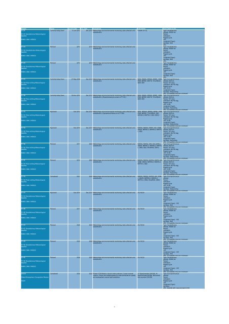
Mission Status Launch Date EOL Date Applications Instruments Orbit Details & URL<br />
FY-2F<br />
Currently being flown 13 Jan 2012 Dec 2016 Meteorology and environmental monitoring; data collection and IVISSR (FY-2)<br />
Type: Geostationary<br />
redistribution.<br />
Altitude: 36000 km<br />
FY-2F Geostationary Meteorological<br />
Period:<br />
Satellite<br />
Inclination:<br />
Repeat cycle:<br />
NSMC-CMA / NRSCC<br />
LST:<br />
Longitude (if geo):<br />
Asc/desc: N/A<br />
URL:<br />
FY-2G<br />
Planned 2013 2016 Meteorology and environmental monitoring; data collection and<br />
Type: Geostationary<br />
redistribution.<br />
Altitude: 36000 km<br />
FY-2G Geostationary Meteorological<br />
Period:<br />
Satellite<br />
Inclination:<br />
Repeat cycle:<br />
NSMC-CMA / NRSCC<br />
LST:<br />
Longitude (if geo):<br />
Asc/desc: N/A<br />
URL:<br />
FY-2H<br />
Planned 2015 2018 Meteorology and environmental monitoring; data collection and<br />
Type: Geostationary<br />
redistribution.<br />
Altitude: 36000 km<br />
FY-2H Geostationary Meteorological<br />
Period:<br />
Satellite<br />
Inclination:<br />
Repeat cycle:<br />
NSMC-CMA / NRSCC<br />
LST:<br />
Longitude (if geo):<br />
Asc/desc: N/A<br />
URL:<br />
FY-3A<br />
Currently being flown 27 May 2008 Dec 2012 Meteorology and environmental monitoring; data collection and IRAS, MWAS, MWHS, MWRI, VIRR, Type: Sun-synchronous<br />
redistribution.<br />
ERM, MERSI, MWTS, TOU/SBUS, Altitude: 830 km<br />
FY-3A Polar-orbiting Meteorological<br />
SEM, SIM<br />
Period: 101 mins<br />
Satellite<br />
Inclination: 98.753 deg<br />
Repeat cycle:<br />
NSMC-CMA / NRSCC<br />
LST: 10:10<br />
Longitude (if geo):<br />
Asc/desc: Descending<br />
URL: fy3.satellite.cma.gov.cn/arssen/<br />
FY-3B<br />
Currently being flown 05 Nov 2010 Dec 2013 Meteorology and environmental monitoring; data collection and IRAS, MWAS, MWHS, MWRI, VIRR, Type: Sun-synchronous<br />
redistribution. (Experimental pre-cursor to FY-3C).<br />
ERM, MERSI, MWTS, TOU/SBUS, Altitude: 830 km<br />
FY-3B Polar-orbiting Meteorological<br />
SEM, SIM<br />
Period: 101 mins<br />
Satellite<br />
Inclination: 98.753 deg<br />
Repeat cycle:<br />
NSMC-CMA / NRSCC<br />
LST: 14:00<br />
Longitude (if geo):<br />
Asc/desc: Ascending<br />
URL: fy3.satellite.cma.gov.cn/arssen/<br />
FY-3C<br />
Approved Dec 2012 Dec 2015 Meteorology and environmental monitoring; data collection and IRAS, IMWAS, MIRAS, MWRI, VIRR, Type: Sun-synchronous<br />
redistribution. (Operational follow-on to FY-3B).<br />
ERM, MERSI, TOU/SBUS, SIM, Altitude: 830 km<br />
FY-3C Polar-orbiting Meteorological<br />
MWHS-2, MWTS-2, SES, SIM-2 Period: 101 mins<br />
Satellite<br />
Inclination: 98.753 deg<br />
Repeat cycle:<br />
NSMC-CMA / NRSCC<br />
LST: 10:00<br />
Longitude (if geo):<br />
Asc/desc: Descending<br />
URL: fy3.satellite.cma.gov.cn/arssen/<br />
FY-3D<br />
Approved Dec 2014 Dec 2017 Meteorology and environmental monitoring; data collection and IMWAS, MIRAS, MWRI, ASI, GAMI, Type: Sun-synchronous<br />
redistribution.<br />
GNOS, MERSI-2, MWHS-2, MWTS- Altitude: 830 km<br />
FY-3D Polar-orbiting Meteorological<br />
2, SES<br />
Period: 101 mins<br />
Satellite<br />
Inclination: 98.753 deg<br />
Repeat cycle:<br />
NSMC-CMA / NRSCC<br />
LST: 14:00<br />
Longitude (if geo):<br />
Asc/desc: Ascending<br />
URL: fy3.satellite.cma.gov.cn/arssen/<br />
FY-3E<br />
Planned 2017 2020 Meteorology and environmental monitoring; data collection and IMWAS, MIRAS, SIM, ASI, ERM-2, Type: Sun-synchronous<br />
redistribution.<br />
GNOS, MERSI-2, MWHS-2, MWTS- Altitude: 830 km<br />
FY-3E Polar-orbiting Meteorological<br />
2, OMS, SES, WindRAD, SIM-2 Period: 101 mins<br />
Satellite<br />
Inclination: 98.753 deg<br />
Repeat cycle:<br />
NSMC-CMA / NRSCC<br />
LST: 10:00<br />
Longitude (if geo):<br />
Asc/desc: Descending<br />
URL: fy3.satellite.cma.gov.cn/arssen/<br />
FY-3F<br />
Planned 2019 2022 Meteorology and environmental monitoring; data collection and IMWAS, MIRAS, MVIRS, MWRI, ASI, Type: Sun-synchronous<br />
redistribution.<br />
GAMI, GNOS, MERSI-2, MWHS-2, Altitude: 830 km<br />
FY-3F Polar-orbiting Meteorological<br />
MWTS-2, SES<br />
Period: 101 mins<br />
Satellite<br />
Inclination: 98.753 deg<br />
Repeat cycle:<br />
NSMC-CMA / NRSCC<br />
LST: 14:00<br />
Longitude (if geo):<br />
Asc/desc: Ascending<br />
URL: fy3.satellite.cma.gov.cn/arssen/<br />
FY-3G<br />
Considered 2021 2024 Meteorology and environmental monitoring; data collection and IMWAS, MIRAS, MVIRS, ASI, ERM- Type: Sun-synchronous<br />
redistribution.<br />
2, GNOS, MERSI-2, MWHS-2, Altitude:<br />
FY-3G Polar-orbiting Meteorological<br />
MWTS-2, OMS, WindRAD, SIM-2 Period:<br />
Satellite<br />
Inclination:<br />
Repeat cycle:<br />
NSMC-CMA / NRSCC<br />
LST: 10:00<br />
Longitude (if geo):<br />
Asc/desc: Descending<br />
URL: fy3.satellite.cma.gov.cn/arssen/<br />
FY-4A<br />
Approved Dec 2014 Dec 2017 Meteorology and environmental monitoring; data collection and LM, MCSI<br />
Type: Geostationary<br />
redistribution.<br />
Altitude: 36000 km<br />
FY-4A Geostationary Meteorological<br />
Period:<br />
Satellite<br />
Inclination:<br />
Repeat cycle:<br />
NSMC-CMA / NRSCC<br />
LST:<br />
Longitude (if geo): -105<br />
Asc/desc: N/A<br />
URL: fy3.satellite.cma.gov.cn/arssen/<br />
FY-4B<br />
Planned 2017 2020 Meteorology and environmental monitoring; data collection and LM, MCSI<br />
Type: Geostationary<br />
redistribution.<br />
Altitude: 36000 km<br />
FY-4B Geostationary Meteorological<br />
Period:<br />
Satellite<br />
Inclination:<br />
Repeat cycle:<br />
NSMC-CMA / NRSCC<br />
LST:<br />
Longitude (if geo): -105<br />
Asc/desc: N/A<br />
URL: fy3.satellite.cma.gov.cn/arssen/<br />
FY-4C<br />
Planned 2020 2023 Meteorology and environmental monitoring; data collection and LM, MCSI<br />
Type: Geostationary<br />
redistribution.<br />
Altitude: 36000 km<br />
FY-4C Geostationary Meteorological<br />
Period:<br />
Satellite<br />
Inclination:<br />
Repeat cycle:<br />
NSMC-CMA / NRSCC<br />
LST:<br />
Longitude (if geo): -105<br />
Asc/desc: N/A<br />
URL: fy3.satellite.cma.gov.cn/arssen/<br />
FY-4D<br />
Planned 2023 2026 Meteorology and environmental monitoring; data collection and LM, MCSI<br />
Type: Geostationary<br />
redistribution.<br />
Altitude: 36000 km<br />
FY-4D Geostationary Meteorological<br />
Period:<br />
Satellite<br />
Inclination:<br />
Repeat cycle:<br />
NSMC-CMA / NRSCC<br />
LST:<br />
Longitude (if geo): -105<br />
Asc/desc: N/A<br />
URL: fy3.satellite.cma.gov.cn/arssen/<br />
FY-4E<br />
Planned 2026 2029 Meteorology and environmental monitoring; data collection and LM, MCSI<br />
Type: Geostationary<br />
redistribution.<br />
Altitude: 36000 km<br />
FY-4E Geostationary Meteorological<br />
Period:<br />
Satellite<br />
Inclination:<br />
Repeat cycle:<br />
NSMC-CMA / NRSCC<br />
LST:<br />
Longitude (if geo): -105<br />
Asc/desc: N/A<br />
URL: fy3.satellite.cma.gov.cn/arssen/<br />
GACM<br />
Considered 2030 2033 Phase-3 DS Mission, launch order unknown, 3-year nominal UV Spectrometer (GACM), IR Type: Sun-synchronous<br />
mission. Ozone and related gases for intercontinental air quality Spectrometer(GACM), Microwave Altitude:<br />
Global Atmospheric Composition Mission<br />
and stratospheric ozone layer prediction.<br />
limb sounder (GACM)<br />
Period:<br />
Inclination:<br />
NASA<br />
Repeat cycle:<br />
LST:<br />
Longitude (if geo):<br />
Asc/desc:<br />
URL: decadal.gsfc.nasa.gov/gacm.html<br />
8


