OBSERVATION
CEOS EOHB tables June 2012 web - ceos eo handbook
CEOS EOHB tables June 2012 web - ceos eo handbook
- No tags were found...
You also want an ePaper? Increase the reach of your titles
YUMPU automatically turns print PDFs into web optimized ePapers that Google loves.
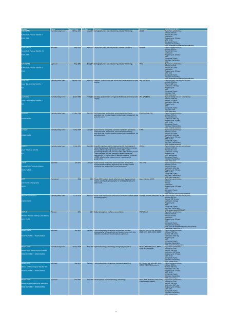
Mission Status Launch Date EOL Date Applications Instruments Orbit Details & URL<br />
KOMPSAT-3<br />
Currently being flown 18 May 2012 May 2016 Cartography, land use and planning, disaster monitoring. AEISS Type: Sun-synchronous<br />
Altitude: 685 km<br />
Korea Multi-Purpose Satellite -3<br />
Period: 98.5 mins<br />
Inclination:<br />
KARI / DLR<br />
Repeat cycle: 28 days<br />
LST: 10:50<br />
Longitude (if geo):<br />
Asc/desc: Ascending<br />
URL: kompsat.kari.re.kr/english/index.asp<br />
KOMPSAT-3A<br />
Approved May 2014 May 2018 Cartography, land use and planning, disaster monitoring. AEISS-A Type: Sun-synchronous<br />
Altitude: 528 km<br />
Korea Multi-Purpose Satellite -3A<br />
Period: 98.5 mins<br />
Inclination:<br />
KARI / DLR<br />
Repeat cycle: 28 days<br />
LST:<br />
Longitude (if geo):<br />
Asc/desc: Ascending<br />
URL:<br />
KOMPSAT-5<br />
Approved May 2012 Dec 2016 Cartography, land use and planning, disaster monitoring. COSI Type: Sun-synchronous<br />
Altitude: 550 km<br />
Korea Multi-Purpose Satellite -5<br />
Period: 98.5 mins<br />
Inclination:<br />
KARI<br />
Repeat cycle: 28 days<br />
LST: 6:00<br />
Longitude (if geo):<br />
Asc/desc: Ascending<br />
URL: kompsat.kari.re.kr/english/index.asp<br />
LAGEOS-1<br />
Currently being flown 04 May 1976 May 2016 Geodesy, crustal motion and gravity field measurements by laser LRA (LAGEOS)<br />
Type: Inclined, non-sun-synchronous<br />
ranging.<br />
Altitude: 5900 km<br />
Laser Geodynamics Satellite - 1<br />
Period: 226 mins<br />
Inclination: 110 deg<br />
ASI<br />
Repeat cycle:<br />
LST:<br />
Longitude (if geo):<br />
Asc/desc: N/A<br />
URL: www.asi.it<br />
LAGEOS-2<br />
Currently being flown 22 Oct 1992 Oct 2032 Geodesy, crustal motion and gravity field measurements by laser LRA (LAGEOS)<br />
Type: Inclined, non-sun-synchronous<br />
ranging.<br />
Altitude: 5800 km<br />
Laser Geodynamics Satellite - 2<br />
Period: 223 mins<br />
Inclination: 52.6 deg<br />
ASI<br />
Repeat cycle:<br />
LST:<br />
Longitude (if geo):<br />
Asc/desc: N/A<br />
URL: www.asi.it<br />
Landsat-5<br />
Currently being flown 01 Mar 1984 Dec 2012 Earth resources, land surface, environmental monitoring, MSS (Landsat), TM<br />
Type: Sun-synchronous<br />
agriculture and forestry, disaster monitoring and assessment, ice<br />
Altitude: 705 km<br />
and snow cover.<br />
Period: 98.9 mins<br />
USGS / NASA<br />
Inclination: 98.2 deg<br />
Repeat cycle: 16 days<br />
LST: 10:00<br />
Longitude (if geo):<br />
Asc/desc: Descending<br />
URL: landsat.usgs.gov/<br />
Landsat-7<br />
Currently being flown 15 Apr 1999 Jan 2017 5-year nominal mission life, currently in extended operations. ETM+<br />
Type: Sun-synchronous<br />
Earth resources, land surface, environmental monitoring,<br />
Altitude: 705 km<br />
agriculture and forestry, disaster monitoring and assessment, ice<br />
Period: 98.9 mins<br />
USGS / NASA<br />
and snow cover.<br />
Inclination: 98.2 deg<br />
Repeat cycle: 16 days<br />
LST: 10:05<br />
Longitude (if geo):<br />
Asc/desc: Descending<br />
URL: landsat.usgs.gov/<br />
LARES<br />
Currently being flown 13 Feb 2012 Feb 2052 Scientific objectives are the measurement of the dragging of LCCRA<br />
Type: Inclined, non-sun-synchronous<br />
inertial frames due to the Earth's angular momentum, or Lense-<br />
Altitude: 1450 km<br />
LAser RElativity Satellite<br />
Thirring effect, and a high precision test of the Earth's<br />
Period: 99.1 mins<br />
gravitomagnetic field with accuracy of the order of a few percent.<br />
Inclination: 71 deg<br />
ASI<br />
Gravitomagnetic field and dragging of inertial frames are<br />
Repeat cycle:<br />
predictions of Einstein's theory of General Relativity. In addition,<br />
LST: Not defined<br />
LARES will allow other measurements in geodesy and<br />
Longitude (if geo):<br />
geodynamics.<br />
Asc/desc: Ascending<br />
URL: www.asi.it<br />
LDCM<br />
Approved Jan 2013 Jan 2018 5-year nominal mission life. Earth resources, land surface, OLI, TIRS<br />
Type: Sun-synchronous<br />
environmental monitoring, agriculture and forestry, disaster<br />
Altitude: 705 km<br />
Landsat Data Continuity Mission<br />
monitoring and assessment, ice and snow cover.<br />
Period: 99 mins<br />
Inclination: 98.2 deg<br />
NASA / USGS<br />
Repeat cycle: 16 days<br />
LST: 10:00<br />
Longitude (if geo):<br />
Asc/desc: Descending<br />
URL: ldcm.nasa.gov/<br />
LIST<br />
Considered 2030 2033 Phase-3 DS Mission, launch order unknown, 3-year nominal Laser altimeter (LIST)<br />
Type: Sun-synchronous<br />
mission. Land surface topography for landslide hazards and<br />
Altitude:<br />
Lidar Surface Topography<br />
water runoff.<br />
Period:<br />
Inclination:<br />
NASA<br />
Repeat cycle: 365 days<br />
LST:<br />
Longitude (if geo):<br />
Asc/desc:<br />
URL: decadal.gsfc.nasa.gov/list.html<br />
MEGHA-TROPIQUES<br />
Currently being flown 12 Oct 2011 Nov 2014 Study of the inter-tropical zone and its convective systems (water ScaRaB, SAPHIR, MADRAS, ROSA Type: Inclined, non-sun-synchronous<br />
and energy cycles).<br />
Altitude: 867 km<br />
Period: 102.16 mins<br />
CNES / ISRO<br />
Inclination: 20 deg<br />
Repeat cycle:<br />
LST:<br />
Longitude (if geo):<br />
Asc/desc: Ascending<br />
URL: smsc.cnes.fr/MEGHAT/<br />
MERLIN<br />
Planned 2016 2019 Global atmospheric methane concentration. IPDA LIDAR Type: Sun-synchronous<br />
Altitude: 500 km<br />
Methane Remote Sensing Lidar Mission<br />
Period: 90 mins<br />
Inclination:<br />
DLR / CNES<br />
Repeat cycle: 28 days<br />
LST:<br />
Longitude (if geo):<br />
Asc/desc: Ascending<br />
URL: www.dlr.de/rd/desktopdefault.aspx/tabid-<br />
2440/3586_read-31672/<br />
Meteor-3M N2<br />
Approved Apr 2012 Apr 2016 Hydrometeorology, climatology, land surface, physical<br />
BRK, MTVZA, IKFS-2, MSU-MR, Type: Sun-synchronous<br />
oceanography, heliogeophysics and space environment, data MSGI-MKA, DCS , SAR, KMSS Altitude: 1024 km<br />
collection, sounding of the atmosphere, agriculture.<br />
Period: 105.3 mins<br />
ROSHYDROMET / ROSKOSMOS<br />
Inclination: 99.6 deg<br />
Repeat cycle:<br />
LST:<br />
Longitude (if geo):<br />
Asc/desc: Ascending<br />
URL: sputnik1.infospace.ru/<br />
Meteor-M N1<br />
Currently being flown 17 Sep 2009 Sep 2014 Hydrometeorology, climatology, heliogeophysics, DCS. MTVZA, MSU-MR, DCS , KMSS, Type: Sun-synchronous<br />
GGAK-M, Severjanin<br />
Altitude: 820 km<br />
Meteor-M N1 Meteorological Satellite<br />
Period: 102 mins<br />
Inclination: 98.79 deg<br />
ROSHYDROMET / ROSKOSMOS<br />
Repeat cycle: 37 days<br />
LST: 09:30<br />
Longitude (if geo):<br />
Asc/desc: Ascending<br />
URL: planet.iitp.ru<br />
Meteor-M N2<br />
Approved Sep 2012 Sep 2017 Hydrometeorology, climatology, heliogeophysics, DCS. MTVZA, IKFS-2, MSU-MR, DCS , Type: Sun-synchronous<br />
KMSS, GGAK-M, Severjanin Altitude: 835 km<br />
Meteor-M Meteorological Satellite N2<br />
Period: 102 mins<br />
Inclination: 98.7 deg<br />
ROSHYDROMET / ROSKOSMOS<br />
Repeat cycle: 37 days<br />
LST: 09:30<br />
Longitude (if geo):<br />
Asc/desc: Ascending<br />
URL: planet.iitp.ru<br />
Meteor-M N3<br />
Approved Dec 2015 Dec 2020 Oceanography, hydrometeorology, climatology. DCS , SAR, Radiomet, OCS, CZS, Type: Sun-synchronous<br />
Scatterometer (Meteor)<br />
Altitude: 835 km<br />
Meteor-M Oceanographical Satellite N3<br />
Period: 102 mins<br />
Inclination: 98.7 deg<br />
ROSHYDROMET / ROSKOSMOS<br />
Repeat cycle: 37 days<br />
LST: TBD<br />
Longitude (if geo):<br />
Asc/desc: Ascending<br />
URL: planet.iitp.ru<br />
12


