

OBSERVATION
CEOS EOHB tables June 2012 web - ceos eo handbook
CEOS EOHB tables June 2012 web - ceos eo handbook
- No tags were found...

You also want an ePaper? Increase the reach of your titles
YUMPU automatically turns print PDFs into web optimized ePapers that Google loves.
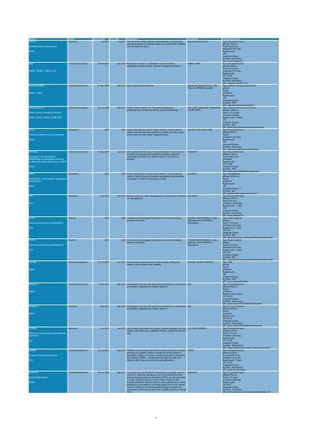
Mission Status Launch Date EOL Date Applications Instruments Orbit Details & URL<br />
OCO-2<br />
Approved Jul 2014 Jul 2017 High resolution carbon dioxide measurements to characterize Spectrometer (OCO-2)<br />
Type: Sun-synchronous<br />
sources and sinks on regional scales and quantify their variability<br />
Altitude: 705 km<br />
Orbiting Carbon Observatory-2<br />
over the seasonal cycle.<br />
Period: 98.8 mins<br />
Inclination: 98.2 deg<br />
NASA<br />
Repeat cycle:<br />
LST:<br />
Longitude (if geo):<br />
Asc/desc: Ascending<br />
URL: oco.jpl.nasa.gov/<br />
Odin<br />
Currently being flown 20 Feb 2001 Dec 2012 Atmospheric research, stratospheric ozone chemistry,<br />
OSIRIS, SMR<br />
Type: Sun-synchronous<br />
mesospheric ozone science, summer mesospheric science.<br />
Altitude: 590 km<br />
Period: 97.6 mins<br />
SNSB / TEKES / CNES / CSA<br />
Inclination: 97.8 deg<br />
Repeat cycle:<br />
LST: 18:00<br />
Longitude (if geo):<br />
Asc/desc: Ascending<br />
URL: www.ssc.se/?id=7180<br />
Ørsted (Oersted)<br />
Currently being flown 21 Nov 1999 Dec 2012 Earth magnetic field mapping. Overhauser Magnetometer, CSC Type: Inclined, non-sun-synchronous<br />
FVM, SI, GPSRO (Oersted) Altitude:<br />
Period:<br />
DNSC / CNES<br />
Inclination:<br />
Repeat cycle:<br />
LST:<br />
Longitude (if geo):<br />
Asc/desc: TBD<br />
URL: web.dmi.dk/projects/oersted/<br />
OSTM (Jason-2)<br />
Currently being flown 20 Jun 2008 Dec 2013 3-year nominal mission life. Physical oceanography,<br />
LRA, JMR, DORIS-NG, POSEIDON- Type: Inclined, non-sun-synchronous<br />
geodesy/gravity, climate monitoring, marine meteorology. 3, AMR, GPSP<br />
Altitude: 1336 km<br />
Ocean Surface Topography Mission<br />
Period: 112.4 mins<br />
Inclination: 66 deg<br />
NASA / NOAA / CNES / EUMETSAT<br />
Repeat cycle: 10 days<br />
LST:<br />
Longitude (if geo):<br />
Asc/desc: N/A<br />
URL: sealevel.jpl.nasa.gov/mission/ostm.html<br />
PACE<br />
Considered 2019 2021 Phase-2 DS Mission, launch order unknown, 3-year nominal Next Gen APS (ACE), OES Type: Sun-synchronous<br />
mission. Aerosol and cloud profiles for climate and water cycle;<br />
Altitude: 650 km<br />
Preliminary Aerosol, Cloud, Ecosystem<br />
ocean colour for open ocean biogeochemistry.<br />
Period:<br />
Inclination: 98.2 deg<br />
NASA<br />
Repeat cycle:<br />
LST:<br />
Longitude (if geo):<br />
Asc/desc: Ascending<br />
URL: dsm.gsfc.nasa.gov/ace/index.html<br />
PARASOL<br />
Currently being flown 01 Dec 2004 Jun 2012 Micro-satellite with the aim of characterisation of the clouds and POLDER-P<br />
Type: Sun-synchronous<br />
aerosols microphysical and radiative properties, needed to<br />
Altitude: 700 km<br />
Polarization and Anisotropy of<br />
understand and model the radiative impact of clouds and<br />
Period: 98.8 mins<br />
Reflectances for Atmospheric Science<br />
aerosols.<br />
Inclination:<br />
coupled with Observations from a LIDAR<br />
Repeat cycle:<br />
LST: 12:00<br />
CNES<br />
Longitude (if geo):<br />
Asc/desc: TBD<br />
URL: smsc.cnes.fr/PARASOL/index.htm<br />
PATH<br />
Considered 2030 2033 Phase-3 DS Mission, launch order unknown, 3-year nominal GeoSTAR<br />
Type: Geostationary<br />
mission. High frequency, all-weather temperature and humidity<br />
Altitude: 42000 km<br />
Precipitation and All-weather Temperature<br />
soundings for weather forecasting and SST.<br />
Period:<br />
and Humidity<br />
Inclination:<br />
Repeat cycle:<br />
NASA<br />
LST:<br />
Longitude (if geo): 0<br />
Asc/desc: N/A<br />
URL: decadal.gsfc.nasa.gov/path.html<br />
PAZ<br />
Approved Feb 2013 Feb 2018 Security, land use, urban management, environmental monitoring, Paz SAR-X<br />
Type: Sun-synchronous<br />
risk management.<br />
Altitude: 514 km<br />
Period: 95 mins<br />
CDTI<br />
Inclination: 97.44 deg<br />
Repeat cycle: 11 days<br />
LST:<br />
Longitude (if geo):<br />
Asc/desc: Ascending<br />
URL: www.hisdesat.es<br />
PCW-1<br />
Planned 2018 2028 Continuous meteorological observation and communications PCWMP, PCW PHEMOS - Solar- Type: Highly elliptical<br />
service to the Arctic.<br />
Terrestrial, PCW PHEMOS - Altitude:<br />
Polar Communications and Weather-1<br />
Atmospheric<br />
Period: 718 mins<br />
Inclination: 63.4 deg<br />
CSA<br />
Repeat cycle: 1 days<br />
LST: N/A<br />
Longitude (if geo):<br />
Asc/desc: N/A<br />
URL: www.asc-csa.gc.ca/eng/satellites/pcw/default.asp<br />
PCW-2<br />
Planned 2018 2028 Continuous meteorological observation and communications PCWMP, PCW PHEMOS - Solar- Type: Highly elliptical<br />
service to the Arctic.<br />
Terrestrial, PCW PHEMOS - Altitude:<br />
Polar Communications and Weather-2<br />
Atmospheric<br />
Period: 718 mins<br />
Inclination: 63.4 deg<br />
CSA<br />
Repeat cycle: 1 days<br />
LST: N/A<br />
Longitude (if geo):<br />
Asc/desc: N/A<br />
URL: www.asc-csa.gc.ca/eng/satellites/pcw/default.asp<br />
PICARD<br />
Currently being flown 15 Jun 2010 Jun 2013 Simultaneous measurements of solar diameter, differential SODISM, SOVAP, PREMOS Type: TBD<br />
rotation, solar constant, and variability.<br />
Altitude:<br />
Period:<br />
CNES<br />
Inclination:<br />
Repeat cycle:<br />
LST:<br />
Longitude (if geo):<br />
Asc/desc: TBD<br />
URL: smsc.cnes.fr/PICARD/<br />
Pleiades 1<br />
Currently being flown 17 Dec 2011 Dec 2016 Cartography, land use, risk, agriculture and forestry, civil planning HiRI<br />
Type: Sun-synchronous<br />
and mapping, digital terrain models, defence.<br />
Altitude: 694 km<br />
Period:<br />
CNES<br />
Inclination:<br />
Repeat cycle: 26 days<br />
LST: 10:15<br />
Longitude (if geo):<br />
Asc/desc: Descending<br />
URL: smsc.cnes.fr/PLEIADES/Fr/index.htm<br />
Pleiades 2<br />
Approved Mar 2013 Mar 2018 Cartography, land use, risk, agriculture and forestry, civil planning HiRI<br />
Type: Sun-synchronous<br />
and mapping, digital terrain models, defence.<br />
Altitude: 694 km<br />
Period:<br />
CNES<br />
Inclination:<br />
Repeat cycle:<br />
LST: 10:15<br />
Longitude (if geo):<br />
Asc/desc: Descending<br />
URL: smsc.cnes.fr/PLEIADES/Fr/index.htm<br />
PRISMA<br />
Approved Jun 2014 Jun 2019 Land surface, agriculture and forestry, regional geology, land use HYC, PAN CAMERA<br />
Type: Sun-synchronous<br />
studies, water resources, vegetation studies, coastal studies and<br />
Altitude: 615 km<br />
PRecursore IperSpettrale della Missione<br />
soils.<br />
Period: 97 mins<br />
Applicativa<br />
Inclination: 97.9 deg<br />
Repeat cycle:<br />
ASI<br />
LST: 10:30<br />
Longitude (if geo):<br />
Asc/desc: Descending<br />
URL: www.asi.it/en/activity/earth_observation/prisma_<br />
PROBA<br />
Currently being flown 22 Oct 2001 Dec 2012 PROBA is a technology experiment to demonstrate the on-board CHRIS<br />
Type: Sun-synchronous<br />
autonomy of a generic platform suitable for small scientific or<br />
Altitude: 615 km<br />
Project for On-Board Autonomy<br />
application missions. A number of earth observation instruments<br />
Period: 96.97 mins<br />
are included. CHRIS - a hyperspectral imager provides data<br />
Inclination: 97.9 deg<br />
ESA<br />
related to Earth Resources science and applications.<br />
Repeat cycle: 7 days<br />
LST: 10:30<br />
Longitude (if geo):<br />
Asc/desc: Descending<br />
URL: earth.esa.int/proba/<br />
QuikSCAT<br />
Currently being flown 19 Jun 1999 Sep 2013 The 3-year nominal QuikSCAT mission life is complete, and it is SeaWinds<br />
Type: Sun-synchronous<br />
currently in extended operations. Due to technical failure (the<br />
Altitude: 803 km<br />
Quick Scatterometer<br />
antenna stopped rotating in November 2009), and the instrument<br />
Period: 101 mins<br />
no longer collects ocean wind vector data. However it still<br />
Inclination: 98.6 deg<br />
NASA<br />
provides calibration data for other on-orbit scatterometers, which<br />
Repeat cycle:<br />
enables the continuation of a climate-quality wind vector dataset.<br />
LST: 6:00<br />
The 2011 NASA Senior Review panel strongly endorsed the<br />
Longitude (if geo):<br />
continuation of the mission with these modified objectives through<br />
Asc/desc: Ascending<br />
2013.<br />
URL: winds.jpl.nasa.gov/missions/quikscat/index.cfm<br />
15


