

OBSERVATION
CEOS EOHB tables June 2012 web - ceos eo handbook
CEOS EOHB tables June 2012 web - ceos eo handbook
- No tags were found...

Create successful ePaper yourself
Turn your PDF publications into a flip-book with our unique Google optimized e-Paper software.
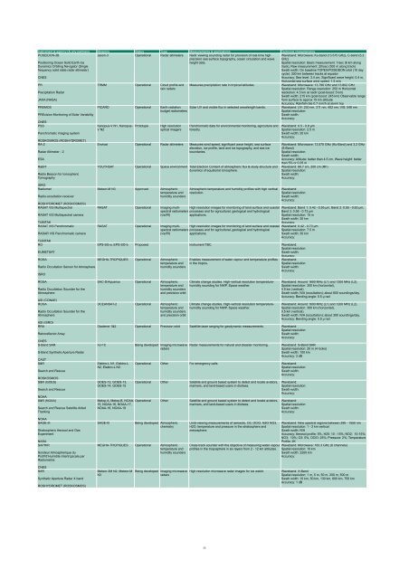
Instrument & agency (& any partners) Missions Status Type Measurements & applications Technical characteristics<br />
POSEIDON-3B<br />
Jason-3 Operational Radar altimeters Nadir viewing sounding radar for provision of real-time high<br />
precision sea surface topography, ocean circulation and wave<br />
height data.<br />
Positioning Ocean Solid Earth Ice<br />
Dynamics Orbiting Navigator (Single<br />
frequency solid state radar altimeter)<br />
CNES<br />
PR<br />
Precipitation Radar<br />
JAXA (NASA)<br />
PREMOS<br />
PREcision Monitoring of Solar Variability<br />
CNES<br />
PSS<br />
Panchromatic imaging system<br />
ROSKOSMOS (ROSHYDROMET)<br />
RA-2<br />
Radar Altimeter - 2<br />
ESA<br />
RaBIT<br />
Radio Beacon for Ionospheric<br />
Tomography<br />
ISRO<br />
Radiomet<br />
Radio-occultation receiver<br />
ROSHYDROMET (ROSKOSMOS)<br />
RASAT VIS Multispectral<br />
RASAT VIS Multispectral camera<br />
TUBITAK<br />
RASAT VIS Panchromatic<br />
RASAR VIS Panchromatic camera<br />
TUBITAK<br />
RO<br />
EUMETSAT<br />
ROSA<br />
Radio Occultation Sensor for Atmosphere<br />
ISRO<br />
TRMM Operational Cloud profile and<br />
rain radars<br />
Measures precipitation rate in tropical latitudes.<br />
PICARD Operational Earth radiation Solar UV and visible flux in selected wavelength bands.<br />
budget radiometers<br />
Kanopus-V N1, Kanopus-<br />
V N2<br />
Prototype<br />
High resolution<br />
optical imagers<br />
Panchromatic data for environmental monitoring, agriculture and<br />
forestry.<br />
Envisat Operational Radar altimeters Measures wind speed, significant wave height, sea surface<br />
elevation, ice profile, land and ice topography, and sea ice<br />
boundaries.<br />
YOUTHSAT Operational Space environment Total Electron Content of atmospheric flux & study structure and<br />
dynamics of equatorial ionosphere.<br />
Meteor-M N3 Approved Atmospheric<br />
temperature and<br />
humidity sounders<br />
Atmospheric temperature and humidity profiles with high vertical<br />
resolution.<br />
Waveband: Microwave: Ku-band (13.575 GHz), C-band (5.3<br />
GHz)<br />
Spatial resolution: Basic measurement: 1/sec (6 km along<br />
track), Raw measurement: 20/sec (300 m along track)<br />
Swath width: On baseline TOPEX/POSEIDON orbit (10 day<br />
cycle): 300 km between tracks at equator<br />
Accuracy: Sea level: 3.4 cm, Significant wave height: 0.4 m,<br />
Horizontal sea surface wind speed: 1.5 m/s<br />
Waveband: Microwave: 13.796 GHz and 13.802 GHz<br />
Spatial resolution: Range resolution: 250 m Horizontal<br />
resolution: 4.3 km at nadir (post-boost: 5 km)<br />
Swath width: 215 km (post-boost: 245 km) Observable range:<br />
from surface to approx 15 km altitude<br />
Accuracy: Rainfall rate 0.7 mm/h at storm top<br />
Waveband: UV: 230 nm, 311 nm, 402 nm; VIS: 548 nm<br />
Spatial resolution:<br />
Swath width:<br />
Accuracy:<br />
Waveband: 0.5 - 0.8 µm<br />
Spatial resolution: 2.5 m<br />
Swath width: 20 km<br />
Accuracy:<br />
Waveband: Microwave: 13.575 GHz (Ku-Band) and 3.2 GHz<br />
(S-Band)<br />
Spatial resolution:<br />
Swath width:<br />
Accuracy: Altitude: better than 4.5 cm, Wave height: better<br />
than 5% or 0.25 m<br />
Waveband: 66.7 cm, 200 cm (RF)<br />
Spatial resolution:<br />
Swath width:<br />
Accuracy:<br />
Waveband:<br />
Spatial resolution:<br />
Swath width:<br />
Accuracy:<br />
RASAT Operational Imaging multispectral<br />
High resolution images for monitoring of land surface and coastal Waveband: Band 1: 0.42 - 0.55 µm, Band 2: 0.55 - 0.63 µm,<br />
radiometers processes and for agricultural, geological and hydrological Band 3: 0.58 - 0.73 µm<br />
(vis/IR)<br />
applications.<br />
Spatial resolution: 15 m<br />
Swath width: 30 km<br />
Accuracy:<br />
RASAT Operational Imaging multispectral<br />
High resolution images for monitoring of land surface and coastal Waveband: 0.42 - 0.73 µm<br />
radiometers processes and for agricultural, geological and hydrological Spatial resolution: 7.5 m<br />
(vis/IR)<br />
applications.<br />
Swath width: 30 km<br />
Accuracy:<br />
EPS-SG-a, EPS-SG-b Proposed Instrument TBC. Waveband:<br />
Spatial resolution:<br />
Swath width:<br />
Accuracy:<br />
MEGHA-TROPIQUES Operational Atmospheric<br />
temperature and<br />
humidity sounders<br />
Enables measurement of water vapour and temperature profiles<br />
in the tropics.<br />
Waveband:<br />
Spatial resolution:<br />
Swath width:<br />
Accuracy:<br />
ROSA<br />
Radio Occultation Sounder for the<br />
Atmosphere<br />
ASI (CONAE)<br />
ROSA<br />
Radio Occultation Sounder for the<br />
Atmosphere<br />
ASI (ISRO)<br />
RRA<br />
Retroreflector Array<br />
CNES<br />
S-Band SAR<br />
S-Band Synthetic Aperture Radar<br />
CAST<br />
S&R<br />
Search and Rescue<br />
ROSKOSMOS<br />
S&R (GOES)<br />
Search and Rescue<br />
NOAA<br />
S&R (NOAA)<br />
Search and Rescue Satellite Aided<br />
Tracking<br />
NOAA<br />
SAGE-III<br />
Stratospheric Aerosol and Gas<br />
Experiment<br />
NASA<br />
SAPHIR<br />
Sondeur Atmospherique du<br />
Profil'd’Humidite Intertropicale par<br />
Radiometrie<br />
SAC-D/Aquarius Operational Atmospheric<br />
temperature and<br />
humidity sounders<br />
and precision orbit<br />
OCEANSAT-2 Operational Atmospheric<br />
temperature and<br />
humidity sounders<br />
and precision orbit<br />
Climate change studies. High-vertical resolution temperaturehumidity<br />
sounding for NWP. Space weather.<br />
Climate change studies. High-vertical resolution temperaturehumidity<br />
sounding for NWP. Space weather.<br />
Diademe 1&2 Operational Precision orbit Satellite laser ranging for geodynamic measurements. Waveband:<br />
Spatial resolution:<br />
Swath width:<br />
Accuracy:<br />
HJ-1C<br />
Elektro-L N1, Elektro-L<br />
N2, Elektro-L N3<br />
GOES-12, GOES-13,<br />
GOES-14, GOES-15<br />
Being developed Imaging microwave<br />
radars<br />
Radar measurements for natural and disaster monitoring.<br />
Waveband: Around 1600 MHz (L1) and 1200 MHz (L2).<br />
Spatial resolution: 300 km (horizontal),<br />
0.5 km (vertical).<br />
Swath width: N/A (occultation); about 600 soundings/day.<br />
Accuracy: Bending angle: 0.5 µ rad<br />
Waveband: Around 1600 MHz (L1) and 1200 MHz (L2).<br />
Spatial resolution: 300 km (horizontal),<br />
0.5 km (vertical).<br />
Swath width: N/A (occultation); about 300 soundings/day.<br />
Accuracy: Bending angle: 0.5 µ rad<br />
Waveband: S-Band SAR<br />
Spatial resolution: 20 m (4 looks)<br />
Swath width: 100 km<br />
Accuracy: 3 dB<br />
Operational Other For emergency calls. Waveband:<br />
Spatial resolution:<br />
Swath width:<br />
Accuracy:<br />
Operational Other Satellite and ground based system to detect and locate aviators,<br />
mariners, and land-based users in distress.<br />
Metop-A, Metop-B, NOAA- Operational Other Satellite and ground based system to detect and locate aviators,<br />
15, NOAA-16, NOAA-17,<br />
mariners, and land-based users in distress.<br />
NOAA-18, NOAA-19<br />
SAGE-III<br />
Being developed Atmospheric<br />
chemistry<br />
MEGHA-TROPIQUES Operational Atmospheric<br />
temperature and<br />
humidity sounders<br />
Limb-viewing measurements of aerosols, O3, OClO, N2O NO3,<br />
H2O, temperature and pressure in the stratosphere and<br />
mesosphere.<br />
Cross-track sounder with the objective of measuring water vapour<br />
profiles in the troposphere in six layers from 2 - 12 km altitudes.<br />
Waveband:<br />
Spatial resolution:<br />
Swath width:<br />
Accuracy:<br />
Waveband:<br />
Spatial resolution:<br />
Swath width:<br />
Accuracy:<br />
Waveband: Nine spectral regions between 290 - 1550 nm<br />
Spatial resolution: 1 - 2 km vertical<br />
Swath width: N/A<br />
Accuracy: Aerosol profile: 5%, H20: 10 - 15%; NO2: 10-15%;<br />
NO3: 10%; O3: 5%; OClO: 25%; Pressure: 2%; Temperature<br />
Profile; 2K<br />
Waveband: Microwave: 183.3 GHz (6 channels)<br />
Spatial resolution: 10 km<br />
Swath width: 2200 km<br />
Accuracy:<br />
CNES<br />
SAR<br />
Synthetic Aperture Radar X band<br />
ROSHYDROMET (ROSKOSMOS)<br />
Meteor-3M N2, Meteor-M<br />
N3<br />
Being developed Imaging microwave<br />
radars<br />
High resolution microwave radar images for ice watch.<br />
Waveband: X-Band<br />
Spatial resolution: 1 m, 5 m, 50 m, 200 m, 500 m<br />
Swath width: 10 km, 50 km, 130 km, 600 km, 750 km<br />
Accuracy: 1 dB<br />
35


