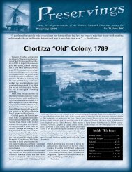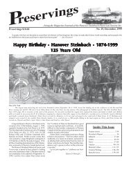
Preservings 11 (1997) - Plett Foundation
Preservings 11 (1997) - Plett Foundation
Preservings 11 (1997) - Plett Foundation

You also want an ePaper? Increase the reach of your titles
YUMPU automatically turns print PDFs into web optimized ePapers that Google loves.
cated the church.<br />
The church was located on NE16-6-6, the<br />
Schinkel homestead. The congregation at that<br />
time from the statistics given by Pastor Beer,<br />
stated that from July 1898 until June 15, 1900,<br />
a period of only two years, he had baptized 18<br />
persons, confirmed 8 and had given communion<br />
to 262 persons. The congregation then totalled<br />
150.<br />
The congregation continued to grow so rapidly<br />
that within three years the original building<br />
was too small to serve as a church. So in<br />
1903 a second building was erected on the same<br />
yard. It had seating for some 250 persons. The<br />
No. <strong>11</strong>, December, <strong>1997</strong><br />
name of the congregation was then changed<br />
from Peace to St. Pauls. On November 8, 1903<br />
the dedication of the new St. Pauls Lutheran<br />
Church took place. The old church continued<br />
to serve as a school.<br />
The original church council consisted of<br />
Stanislaus Schielke, Gottlieb Wiesner and<br />
Gottlieb Krentz, and Gottlieb Staerk was the<br />
assistant carpenter for the building of the<br />
church.<br />
The Krentz Family.<br />
Eventually all of Gottlieb and Karoline’s<br />
children married. Emilie married George<br />
79<br />
Goritz. Gottlieb married Juliana Schmidke.<br />
Christof married Emilie Borowski. Leo married<br />
Olga Laeckelt. Emil married Olga Weiss,<br />
however she passed away during childbirth of<br />
a son who also died. Emil then remarried to<br />
Francis Wonnek a few years later.<br />
In 1920, their son Christof took over the farm<br />
and lived there till 1954. Christof’s son Arthur<br />
then took over and is still living there today.<br />
Sources:<br />
Genealogy of Michael Krentz 1828-1985<br />
(Steinbach, Manitoba, 1985), 20 pages.<br />
Clearsprings Pioneers:<br />
The First Five Years 1869-1874<br />
Clearsprings Pioneers: The First Five Years 1869-1874; by Ed & Alice Laing, Box 1088, Steinbach, Manitoba, R0A 2A0,<br />
“Clearsprings history buffs”.<br />
Introduction.<br />
Clearsprings - where did the name come<br />
from? Why was it used to name a road, why<br />
was it used to name a large shopping centre<br />
in the city of Steinbach?<br />
To make an old story come to life, let us<br />
tell you that the name “Clearsprings” goes<br />
back many years, back to 1869. The first settlers<br />
of Clearsprings were born in Scotland<br />
in the early 1840s. By mid 1860s these adventurous<br />
young men and women were crossing<br />
the ocean, arriving in Ontario to begin<br />
farming.<br />
Life was exciting in Ontario. Some of<br />
these young men and women soon married.<br />
Land was becoming expensive and when<br />
these young men heard that there was plenty<br />
of fine land of the best quality for a reasonable<br />
price out west they decided that is where<br />
they should go. Before long these young pioneers<br />
sold their land in Ontario, gathered up<br />
their belongings and started west to Manitoba<br />
by train.<br />
At this time the nearest Rail Road terminal<br />
to the Red River Region was St. Cloud,<br />
Minnesota, 400 miles south of Fort Garry,<br />
now Winnipeg, which at that time had a population<br />
of 250. There are many stories written<br />
about how the pioneers made the trip from<br />
St. Cloud by horse and covered-wagon. One<br />
story tells of meeting Louis Riel with his two<br />
aides on the trail as they were fleeing Manitoba<br />
after the Riel Rebellion was quashed by<br />
Colonel Wolseley and his military expedition.<br />
The First Settlers, 1869.<br />
In 1869, before the land was surveyed, the<br />
nearest Post Office was Hudson Bay Company,<br />
Fort Garry, a three-day trip for the mail.<br />
John and Mary Mack from Hensall,<br />
Ontario, are recorded to be the first settlers<br />
to pioneer the area later called Clearsprings<br />
in 1869, located on SW13-7-6E. The Macks<br />
were closely followed by others from Hensall:<br />
Thomas Rankin located on SW<strong>11</strong>-7-6E, the<br />
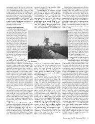
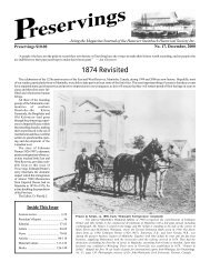
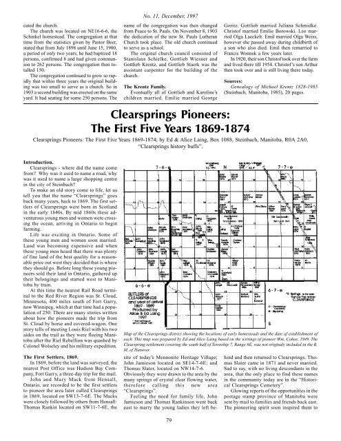
Map of the Clearsprings district showing the locations of early homesteads and the date of establishment of<br />
each. This map was prepared by Ed and Alice Laing based on the writings of pioneer Wm. Cohoe, 1949. The<br />
Clearspring settlement covering the south half of Township 7, Range 6E, was not originaly included in the R.<br />
M. of Hanover.<br />
site of today’s Mennonite Heritage Village;<br />
John Jamieson located on SE14-7-6E; and<br />
Thomas Slater, located on NW14-7-6.<br />
Obviously they were drawn to the area by the<br />
many springs of crystal clear flowing water,<br />
therefore calling this new area<br />
“Clearsprings”.<br />
Feeling the need for family life, John<br />
Jamieson and Thomas Rankinson went back<br />
east to marry the young ladies they left be-<br />
hind and then returned to Clearsprings. Thomas<br />
Slater came in 1871 and never married.<br />
Sad to say, with no living descendants in the<br />
area, that the only place to find these names<br />
in the community today are in the “Historical<br />
Clearsprings Cemetery”.<br />
Glowing reports of the opportunities in the<br />
postage stamp province of Manitoba were<br />
sent by mail to families and friends back east.<br />
The pioneering spirit soon inspired them to