2017-2018-Mercer-Marine-Catalogue
You also want an ePaper? Increase the reach of your titles
YUMPU automatically turns print PDFs into web optimized ePapers that Google loves.
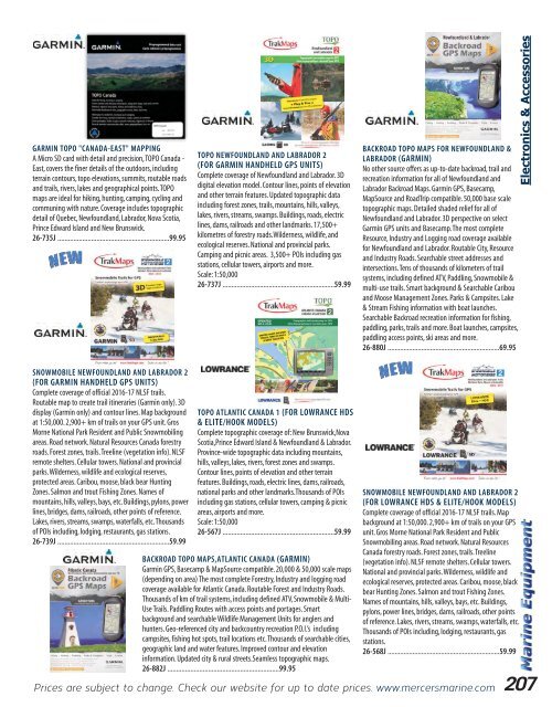
GARMIN TOPO "CANADA-EAST" MAPPING<br />
A Micro SD card with detail and precision, TOPO Canada -<br />
East, covers the finer details of the outdoors, including<br />
terrain contours, topo elevations, summits, routable roads<br />
and trails, rivers, lakes and geographical points. TOPO<br />
maps are ideal for hiking, hunting, camping, cycling and<br />
communing with nature. Coverage includes topographic<br />
detail of Quebec, Newfoundland, Labrador, Nova Scotia,<br />
Prince Edward Island and New Brunswick.<br />
26-735J ...............................................................99.95<br />
TOPO NEWFOUNDLAND AND LABRADOR 2<br />
(FOR GARMIN HANDHELD GPS UNITS)<br />
Complete coverage of Newfoundland and Labrador. 3D<br />
digital elevation model. Contour lines, points of elevation<br />
and other terrain features. Updated topographic data<br />
including forest zones, trails, mountains, hills, valleys,<br />
lakes, rivers, streams, swamps. Buildings, roads, electric<br />
lines, dams, railroads and other landmarks. 17,500+<br />
kilometres of forestry roads.Wilderness, wildlife, and<br />
ecological reserves. National and provincial parks.<br />
Camping and picnic areas. 3,500+ POIs including gas<br />
stations, cellular towers, airports and more.<br />
Scale: 1:50,000<br />
26-737J ...............................................................59.99<br />
BACKROAD TOPO MAPS FOR NEWFOUNDLAND &<br />
LABRADOR (GARMIN)<br />
No other source offers as up-to-date backroad, trail and<br />
recreation information for all of Newfoundland and<br />
Labrador Backroad Maps. Garmin GPS, Basecamp,<br />
MapSource and RoadTrip compatible. 50,000 base scale<br />
topographic maps. Detailed shaded relief for all of<br />
Newfoundland and Labrador. 3D perspective on select<br />
Garmin GPS units and Basecamp. The most complete<br />
Resource, Industry and Logging road coverage available<br />
for Newfoundland and Labrador. Routable City, Resource<br />
and Industry Roads. Searchable street addresses and<br />
intersections. Tens of thousands of kilometers of trail<br />
systems, including defined ATV, Paddling, Snowmobile &<br />
multi-use trails. Smart background & Searchable Caribou<br />
and Moose Management Zones. Parks & Campsites. Lake<br />
& Stream Fishing information with boat launches.<br />
Searchable Backroad recreation information for fishing,<br />
paddling, parks, trails and more. Boat launches, campsites,<br />
paddling access points, ski areas and more.<br />
26-880J ...............................................................69.95<br />
Electronics & Accessories<br />
SNOWMOBILE NEWFOUNDLAND AND LABRADOR 2<br />
(FOR GARMIN HANDHELD GPS UNITS)<br />
Complete coverage of official 2016-17 NLSF trails.<br />
Routable map to create trail itineraries (Garmin only). 3D<br />
display (Garmin only) and contour lines. Map background<br />
at 1:50,000. 2,900+ km of trails on your GPS unit. Gros<br />
Morne National Park Resident and Public Snowmobiling<br />
areas. Road network. Natural Resources Canada forestry<br />
roads. Forest zones, trails. Treeline (vegetation info). NLSF<br />
remote shelters. Cellular towers. National and provincial<br />
parks. Wilderness, wildlife and ecological reserves,<br />
protected areas. Caribou, moose, black bear Hunting<br />
Zones. Salmon and trout Fishing Zones. Names of<br />
mountains, hills, valleys, bays, etc. Buildings, pylons, power<br />
lines, bridges, dams, railroads, other points of reference.<br />
Lakes, rivers, streams, swamps, waterfalls, etc. Thousands<br />
of POIs including, lodging, restaurants, gas stations.<br />
26-739J ...............................................................59.99<br />
TOPO ATLANTIC CANADA 1 (FOR LOWRANCE HDS<br />
& ELITE/HOOK MODELS)<br />
Complete topographic coverage of: New Brunswick,Nova<br />
Scotia,Prince Edward Island & Newfoundland & Labrador.<br />
Province-wide topographic data including mountains,<br />
hills, valleys, lakes, rivers, forest zones and swamps.<br />
Contour lines, points of elevation and other terrain<br />
features. Buildings, roads, electric lines, dams, railroads,<br />
national parks and other landmarks.Thousands of POIs<br />
including gas stations, cellular towers, camping & picnic<br />
areas, airports and more.<br />
Scale: 1:50,000<br />
26-567J ...............................................................59.99<br />
BACKROAD TOPO MAPS,ATLANTIC CANADA (GARMIN)<br />
Garmin GPS, Basecamp & MapSource compatible. 20,000 & 50,000 scale maps<br />
(depending on area) The most complete Forestry, Industry and logging road<br />
coverage available for Atlantic Canada. Routable Forest and Industry Roads.<br />
Thousands of km of trail systems, including defined ATV, Snowmobile & Multi-<br />
Use Trails. Paddling Routes with access points and portages. Smart<br />
background and searchable Wildlife Management Units for anglers and<br />
hunters. Geo-referenced city and backcountry recreation P.O.I.’s including<br />
campsites, fishing hot spots, trail locations etc. Thousands of searchable cities,<br />
geographic land and water features. Improved contour and elevation<br />
information. Updated city & rural streets.Seamless topographic maps.<br />
26-882J ...............................................................99.95<br />
SNOWMOBILE NEWFOUNDLAND AND LABRADOR 2<br />
(FOR LOWRANCE HDS & ELITE/HOOK MODELS)<br />
Complete coverage of official 2016-17 NLSF trails. Map<br />
background at 1:50,000. 2,900+ km of trails on your GPS<br />
unit. Gros Morne National Park Resident and Public<br />
Snowmobiling areas. Road network. Natural Resources<br />
Canada forestry roads. Forest zones, trails. Treeline<br />
(vegetation info). NLSF remote shelters. Cellular towers.<br />
National and provincial parks. Wilderness, wildlife and<br />
ecological reserves, protected areas. Caribou, moose, black<br />
bear Hunting Zones. Salmon and trout Fishing Zones.<br />
Names of mountains, hills, valleys, bays, etc. Buildings,<br />
pylons, power lines, bridges, dams, railroads, other points<br />
of reference. Lakes, rivers, streams, swamps, waterfalls, etc.<br />
Thousands of POIs including, lodging, restaurants, gas<br />
stations.<br />
26-568J ...............................................................59.99<br />
Prices are subject to change. Check our website for up to date prices. www.mercersmarine.com<br />
207


