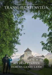
Princely Hikes in Liechtenstein
Which country in Europe has the densest network of hiking trails? It’s not the alpine classics of Switzerland or Austria, but in fact the small Principality of Liechtenstein nestling between those two countries. More than 400 kilometres of well-maintained and clearly signposted trails and majestic mountains up to 2600 metres above sea level attract walkers and hikers to Liechtenstein.
Which country in Europe has the densest network of hiking trails? It’s not the alpine classics of Switzerland or Austria, but in fact the small Principality of Liechtenstein nestling between those two countries. More than 400 kilometres of well-maintained and clearly signposted trails and majestic mountains up to 2600 metres above sea level attract walkers and hikers to Liechtenstein.

Create successful ePaper yourself
Turn your PDF publications into a flip-book with our unique Google optimized e-Paper software.
14 → tourismus.li/hik<strong>in</strong>g<br />
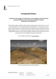
WALKING TRAIL<br />
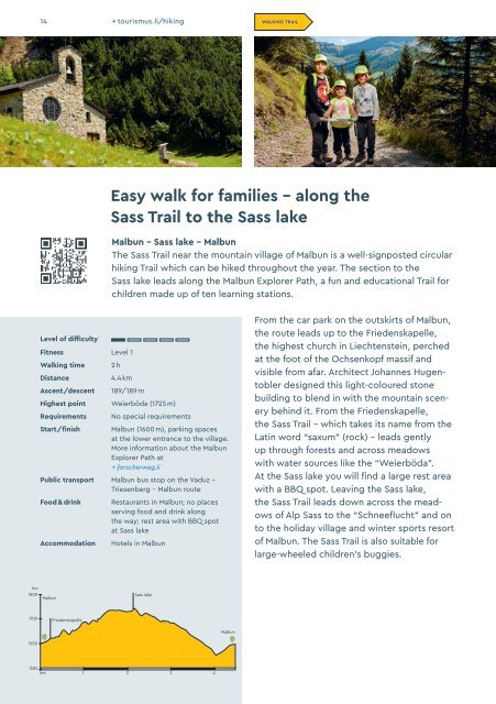
Easy walk for families – along the<br />
Sass Trail to the Sass lake<br />
Malbun - Sass lake - Malbun<br />
The Sass Trail near the mounta<strong>in</strong> village of Malbun is a well-signposted circular<br />
hik<strong>in</strong>g Trail which can be hiked throughout the year. The section to the<br />
Sass lake leads along the Malbun Explorer Path, a fun and educational Trail for<br />
children made up of ten learn<strong>in</strong>g stations.<br />
Level of difficulty<br />
Fitness Level 1<br />
Walk<strong>in</strong>g time<br />
Distance<br />
Ascent/descent<br />
2 h<br />
4.4 km<br />
189/189 m<br />
Highest po<strong>in</strong>t Weierböda (1725 m)<br />
Requirements<br />
Start/f<strong>in</strong>ish<br />
No special requirements<br />
Malbun (1600 m), park<strong>in</strong>g spaces<br />
at the lower entrance to the village.<br />
More <strong>in</strong>formation about the Malbun<br />
Explorer Path at<br />
→ forscherweg.li<br />
Public transport Malbun bus stop on the Vaduz –<br />
Triesenberg – Malbun route<br />
Food & dr<strong>in</strong>k<br />
Accommodation<br />
Restaurants <strong>in</strong> Malbun; no places<br />
serv<strong>in</strong>g food and dr<strong>in</strong>k along<br />
the way; rest area with BBQ spot<br />
at Sass lake<br />
Hotels <strong>in</strong> Malbun<br />
From the car park on the outskirts of Malbun,<br />
the route leads up to the Friedenskapelle,<br />
the highest church <strong>in</strong> Liechtenste<strong>in</strong>, perched<br />
at the foot of the Ochsenkopf massif and<br />
visible from afar. Architect Johannes Hugentobler<br />
designed this light-coloured stone<br />
build<strong>in</strong>g to blend <strong>in</strong> with the mounta<strong>in</strong> scenery<br />
beh<strong>in</strong>d it. From the Friedenskapelle,<br />
the Sass Trail – which takes its name from the<br />
Lat<strong>in</strong> word “saxum” (rock) – leads gently<br />
up through forests and across meadows<br />
with water sources like the “Weierböda”.<br />
At the Sass lake you will f<strong>in</strong>d a large rest area<br />
with a BBQ spot. Leav<strong>in</strong>g the Sass lake,<br />
the Sass Trail leads down across the meadows<br />
of Alp Sass to the “Schneeflucht” and on<br />
to the holiday village and w<strong>in</strong>ter sports resort<br />
of Malbun. The Sass Trail is also suitable for<br />
large-wheeled children’s buggies.<br />
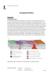
hm<br />
1800<br />
Malbun<br />
Sass lake<br />
1700<br />
Friedenskapelle<br />
Malbun<br />
1600<br />
1500<br />
km 1 2 3 4