
Create successful ePaper yourself
Turn your PDF publications into a flip-book with our unique Google optimized e-Paper software.
60<br />
Continue on the path downhill until you reach a<br />
distinctive wall; turn left here and take the steps down<br />
the steep hill. When you arrive at the foot of the<br />
hill where all the ferns are, there’s two options;<br />
turn right at this point.<br />
Follow the path through the woods, close to<br />
its perimeter with farmland for just under ¾<br />
mile until you reach an exit marked Tarvin<br />
Road. Take this exit and walk down to the<br />
road; turn left and then first right into the<br />
single-track Chestnut Lane.<br />
At its conclusion Chestnut Lane<br />
narrows to a footpath: take the<br />
bridge across the stream and head<br />
in the same direction up the<br />
concrete steps. Follow this evernarrowing<br />
footpath until you<br />
arrive out in the open by a<br />
house called Tong Dean. Go<br />
through the gate opposite<br />
and follow the clearly<br />
defined footpath until<br />
you arrive in Helsby on<br />
Bates Lane.<br />
Turn right and then<br />
turn left at the<br />
crossroads on the<br />
Old Chester Road.<br />
Look out for a<br />
footpath sign<br />
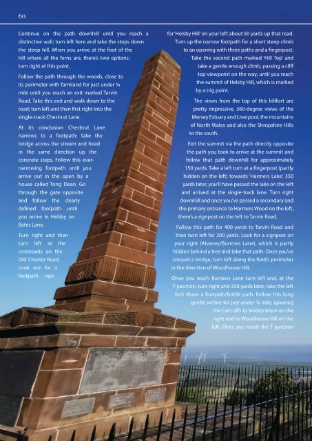
for ‘Helsby Hill’ on your left about 50 yards up that road.<br />
Turn up the narrow footpath for a short steep climb<br />
to an opening with three paths and a fingerpost.<br />
Take the second path marked ‘Hill Top’ and<br />
take a gentle enough climb, passing a cliff<br />
top viewpoint on the way, until you reach<br />
the summit of Helsby Hill, which is marked<br />
by a trig point.<br />
The views from the top of this hillfort are<br />
pretty impressive, 360-degree views of the<br />
Mersey Estuary and Liverpool, the mountains<br />
of North Wales and also the Shropshire Hills<br />
to the south.<br />
Exit the summit via the path directly opposite<br />
the path you took to arrive at the summit and<br />
follow that path downhill for approximately<br />
150 yards. Take a left turn at a fingerpost (partly<br />
hidden on the left) towards ‘Harmers Lake’. 350<br />
yards later, you’ll have passed the lake on the left<br />
and arrived at the single-track lane. Turn right<br />
downhill and once you’ve passed a secondary and<br />
the primary entrance to Harmers Wood on the left,<br />
there’s a signpost on the left to Tarvin Road.<br />
Follow this path for 400 yards to Tarvin Road and<br />
then turn left for 200 yards. Look for a signpost on<br />
your right (Alvaney/Burrows Lane), which is partly<br />
hidden behind a tree and take that path. Once you’ve<br />
crossed a bridge, turn left along the field’s perimeter<br />
in the direction of Woodhouse Hill.<br />
Once you reach Burrows Lane turn left and, at the<br />
T-junction, turn right and 350 yards later, take the left<br />
fork down a footpath/bridle path. Follow this long<br />
gentle incline for just under ¾ mile, ignoring<br />
the turn offs to Snidey Moor on the<br />
right and to Woodhouse Hill on the<br />
left. Once you reach the T-junction