Smart Industry No.1 2022
Smart Industry No.1 2022 - The IoT Business Magazine - powered by Avnet Silica
Smart Industry No.1 2022 - The IoT Business Magazine - powered by Avnet Silica

Create successful ePaper yourself
Turn your PDF publications into a flip-book with our unique Google optimized e-Paper software.
Light detection and ranging<br />
(Lidar) is a remote sensing<br />
method that uses pulsed laser<br />
light to measure ranges<br />
(variable distances). Similar to its<br />
close cousins, radar using radio<br />
waves and sonar emitting sound<br />
waves under water, Lidar uses laser<br />
light to accurately measure ranges<br />
(distances) – something that is critical<br />
for many sectors and industrial<br />
processes.<br />
Theoretically, measurement can be<br />
performed using other technologies,<br />
but Lidar has multiple advantages<br />
over them. For example, it has<br />
a higher resolution than radar and<br />
a wider range than camera sensors<br />
and can even perform in the dark.<br />
Furthermore, Lidar produces 3D<br />
data and can detect and differentiate<br />
objects. As a result, it can be used<br />
to track objects, detect physical protrusions<br />
and survey landscapes.<br />
Measuring carbon dioxide, sulfur<br />
dioxide and methane in the air or<br />
water can also be achieved with<br />
Lidar, making it ideal for things like<br />
geographical surveys, autonomous<br />
driving, industrial applications and<br />
logistics.<br />
source ©: NOAA<br />
The Face of the Earth<br />
Geographical surveys are not just<br />
for mapping mineral and water<br />
resources, they have been used to<br />
map zones prone to earthquakes,<br />
tsunamis, landslides, flooding and<br />
volcanic activity to deal with potential<br />
disasters. In addition, coastlines<br />
need to be surveyed for effective<br />
management and planning for<br />
navigational, environmental and<br />
homeland security purposes.<br />
As global warming raises sea levels<br />
and causes extreme weather events<br />
like enormous floods and droughts,<br />
high-resolution geographical surveys<br />
will be crucial for monitoring<br />
the effects of global warming, such<br />
as coastline erosion. This information<br />
can help governments to devise<br />
coping strategies, such as safe<br />
and responsible land use and emergency<br />
preparedness, to protect civilian<br />
lives and marine wildlife.<br />
The National Oceanic and Atmospheric<br />
Administration (NOAA), an<br />
agency primarily responsible for<br />
mapping US shorelines, sought to<br />
increase the efficiency and reduce<br />
the subjectivity of older technologies,<br />
such as tide coordinated aerial<br />
photography. Data collection in intertidal<br />
zones was also poor because<br />
these areas are too shallow for<br />
survey vessels to approach safely.<br />
NOAA now uses airplanes and helicopters<br />
equipped with two types of<br />
Lidar: topographic and bathymetric.<br />
Topographic Lidar typically uses a<br />
near-infrared laser to map the land,<br />
while bathymetric Lidar uses waterpenetrating<br />
green light to measure<br />
seafloor and riverbed elevations.<br />
Lidar is helping<br />
us understand<br />
sea-level rises<br />
and coastal<br />
flooding/inundation<br />
impacts,<br />
and marine life<br />
habitat mapping.<br />
Stephen White<br />
NOAA<br />
National Ocean Service<br />
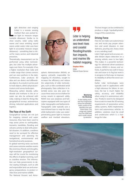
Monitoring<br />
the Warming<br />
A view looking northeast<br />
from Virginia Key<br />
shows the topobathymetric<br />
surface of the<br />
intertidal zone near<br />
Fisher Island. This<br />
image was created<br />
from the LiDAR bare<br />
earth model colored<br />
by elevation.<br />
The two images can be combined to<br />
produce a single ‘topobathymetric’<br />
image of the coastal area.<br />
Driving Force<br />
How do we make sure autonomous<br />
cars and trucks pay proper attention<br />
and avoid disasters in near<br />
darkness, pouring rain, heavy snow<br />
or on a winding road?<br />
Lidar’s high speed and accuracy enable<br />
distant object detection on a<br />
moving vehicle, even in low light.<br />
This makes it a powerful technology<br />
for advanced driver-assistance<br />
systems (ADAS) in drones and vehicles.<br />
It performs less well in heavy<br />
rain and snow or in fog but work is<br />
in progress to find ways to improve<br />
its reliability in all but the worst conditions.<br />
Earlier Lidar technologies were<br />
typically used in applications with<br />
a high tolerance for failure. In contrast,<br />
the bar is much higher for<br />
safety, accuracy, and reliability<br />
when using it in autonomous vehicles.<br />
Products need to be designed<br />
from scratch to meet the 3D sensing<br />
requirements of automotive active<br />
safety systems, ADAS implementations<br />
and autonomous vehicles. In<br />
addition, solutions must be small<br />
and unobtrusive which is a challenge<br />
for Lidar.<br />
83<br />
source ©: NOAA