PDF version - UN Special
PDF version - UN Special
PDF version - UN Special
- No tags were found...

You also want an ePaper? Increase the reach of your titles
YUMPU automatically turns print PDFs into web optimized ePapers that Google loves.
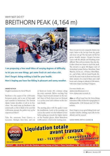
WHY NOT DO IT?BREITHORN PEAK (4,164 m)I am proposing a few small hikes of varying degrees of difficulty,to let you see new things, get some fresh air and relax a bit.Don’t forget: doing nothing is bad for your health.Here’s hoping you have fun hiking in pleasant and sunny weather.Here you put on your crampons, fasten yourropes, listen to the last tips from the guideand away you go! The trip starts out flat butgrows steadily steeper. Oxygen becomesscarce with the altitude and breathing moredifficult. This is all on a stormy, blue-sky day.It takes about two hours to reach the peak.The reward is a great 360-degree view ofSwitzerland: pointe Dufour, Mont Rose, DentBlanche, Cervin, etc.; of France: Mont-Blanc,etc.; and of Italy, with its Grand Paradis. Returnby the same route in about one hour andthirty minutes, for a total of three and a halfhours and a change in altitude of 300 metres,with some slopes reaching 45 degrees.ANDRÉ ROTACH(English translation by David Winch)Breithorn is the easiest of the 4,000-metreEuropean peaks, and is one of forty-eightsuch summits in Switzerland. The ZermattAlpine Center describes it well in its brochure:“the usual route up Breithorn is theeasiest path, as this is likely to be your first4,000-metre attempt; the perfect way up forexperienced hikers”.Take the autoroute from Geneva toLausanne, Martigny then Sion, and exitle sport… mais pas quewww.sport2000-paysdegex.comat Sierre-est (sortie 29); continue alongthe route cantonale. Before reaching Visp(Viège), head towards Zermatt via the tunnel.Once at Täsch, leave your car (Zermattis a car-free zone) and continue on the Zermattshuttle.The meeting place with the guide is nearthe installations, (early in the morning youcan see the sunrise over the brilliant Cervin)before going up towards the higher stationon the Paradise glacier, Klein Matterhorn(3,882 metres), which is the starting point.For more details, see:alpinecenter@zermatt.ch orwww.alpinecenter-zermatt.ch .Also: an official map from the Swiss hikingfederation (Office fédéral de topographie) isindispensable: 1348 Zermatt and 1347 Matterhorn.Don’t forget to wear good hiking boots andweather-suitable clothing, especially for thealtitude and the season!GOOD HIKING (WITH A GUIDE)! ❚Liquidation totaleavant travauxSKI - TEXTILES - CHAUSSURESTout doit disparaîtreSEGNY - RN 5 (à 10 min de Genève, entre Ferney et Gex) • Face Carrefour • Tél. 0033 450 42 38 9045 – <strong>UN</strong> <strong>Special</strong> – Décembre 2009