

Buletin Geospatial Sektor Awam - Bil 1/ 2007 - Malaysia Geoportal
Buletin Geospatial Sektor Awam - Bil 1/ 2007 - Malaysia Geoportal
Buletin Geospatial Sektor Awam - Bil 1/ 2007 - Malaysia Geoportal
- No tags were found...

Create successful ePaper yourself
Turn your PDF publications into a flip-book with our unique Google optimized e-Paper software.
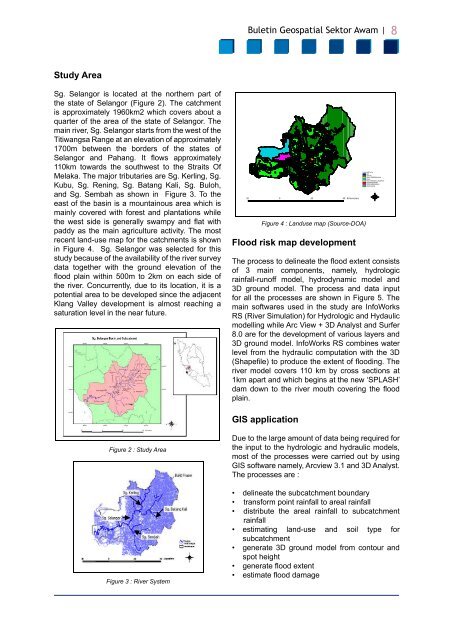
<strong>Buletin</strong> <strong>Geospatial</strong> <strong>Sektor</strong> <strong>Awam</strong> | 8Study AreaSg. Selangor is located at the northern part ofthe state of Selangor (Figure 2). The catchmentis approximately 1960km2 which covers about aquarter of the area of the state of Selangor. Themain river, Sg. Selangor starts from the west of theTitiwangsa Range at an elevation of approximately1700m between the borders of the states ofSelangor and Pahang. It flows approximately110km towards the southwest to the Straits OfMelaka. The major tributaries are Sg. Kerling, Sg.Kubu, Sg. Rening, Sg. Batang Kali, Sg. Buloh,and Sg. Sembah as shown in Figure 3. To theeast of the basin is a mountainous area which ismainly covered with forest and plantations whilethe west side is generally swampy and flat withpaddy as the main agriculture activity. The mostrecent land-use map for the catchments is shownin Figure 4. Sg. Selangor was selected for thisstudy because of the availability of the river surveydata together with the ground elevation of theflood plain within 500m to 2km on each side ofthe river. Concurrently, due to its location, it is apotential area to be developed since the adjacentKlang Valley development is almost reaching asaturation level in the near future.Guna Tanah 199720 0 20 40 K ilometersFigure 4 : Landuse map (Source-DOA)Flood risk map developmentLanduse97.shpAIRHUTANKAW. DIBERSIHKANPAYAPDG.TERNAK & RUMPUTPERBANDARANPERLOMBONGANPERTANIANThe process to delineate the flood extent consistsof 3 main components, namely, hydrologicrainfall-runoff model, hydrodynamic model and3D ground model. The process and data inputfor all the processes are shown in Figure 5. Themain softwares used in the study are InfoWorksRS (River Simulation) for Hydrologic and Hydaulicmodelling while Arc View + 3D Analyst and Surfer8.0 are for the development of various layers and3D ground model. InfoWorks RS combines waterlevel from the hydraulic computation with the 3D(Shapefile) to produce the extent of flooding. Theriver model covers 110 km by cross sections at1km apart and which begins at the new ‘SPLASH’dam down to the river mouth covering the floodplain.WNSEGIS applicationFigure 2 : Study AreaFigure 3 : River SystemDue to the large amount of data being required forthe input to the hydrologic and hydraulic models,most of the processes were carried out by usingGIS software namely, Arcview 3.1 and 3D Analyst.The processes are :• delineate the subcatchment boundary• transform point rainfall to areal rainfall• distribute the areal rainfall to subcatchmentrainfall• estimating land-use and soil type forsubcatchment• generate 3D ground model from contour andspot height• generate flood extent• estimate flood damage


