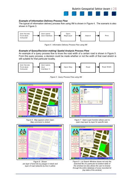
<strong>Buletin</strong> <strong>Geospatial</strong> <strong>Sektor</strong> <strong>Awam</strong> | 28Example of Information Delivery Process FlowThe typical of information delivery process flow using IIM is shown in Figure 4. The scenario is alsoshown in Figure 3.Us er Acc essFront-de skCom puterUs er opensUs er InterfaceOp enMap/Layer Search Pri ntFigure 4 : Information Delivery Process Flow using IIMExample of Query/Decision-making/ Spatial Analysis Process FlowAn example of a query process flow to know the road width of a certain road is shown in Figure 5.From this query process, a decision could be made whether or not the width of that road stretch isstill suitable for that particular locality.Us er Acc essFront-de skCom puterUs er opensUs erInterface / IIOp en Map Road Road WidthFigure 5 : Query Process Flow using IIMFigure 6 : Map appears when OpenMap command is clickedFigure 7 : Open Layer function allows user toopen map layer by layer for specific task.Figure 8 : Shownare layer of land lots by polygon in black andlayer of road networks by line in yellowFigure 9 : Lot Search Window shows not only thesearched file of a particular lot (bottom table ofthe window) but also allows the user to browsethrough the entire database of every recorded lot(top table of the window)
<strong>Buletin</strong> <strong>Geospatial</strong> <strong>Sektor</strong> <strong>Awam</strong> |29Figure 10 : Road function allows user to viewcorresponding file of a particular roadDISCUSSION AND CONCLUSIONA computerized information delivery system suchas IIM will improve significantly the informationdelivery to the clients of MBI. It is expected tobe four (4) times as fast compared to manualinformation delivery. At the same time it is expectedthat more clients ((four (4) times as many)) couldbe entertained at any one particular time. A betterutilization of human resources will also be possiblewith this application in place since less personnelor none would be required to perform a very basicroutine job (manual file search, photocopying,etc) instead he/she could be assigned for job withhigher role profile which will improve the humanresource utilization in the organization. Generally,by implementing the computerized informationdelivery system, the revenue of the departmentconcern would increase by almost 30%. Besidesthe IIM implementation would also improvecommunication within the department and withless paper work.However, prior to embarking on such a system,additional budget and additional training fora certain number of staff will be required.Nevertheless in the long run the organization willgain by implementing such a system.ACKNOWLEDGEMENTSThe author would like to thank the Departmentof Town Planning of Majlis Bandaraya Ipoh andMajlis Perbandaran Taiping for their assistancein the preparation of this paper. Special thanksalso goes to Mr Mohamad Shahrustami bin MohdNadzeri for compiling and developing the userinterface for this study.Figure 11 : Find function allows user to performspatial search based on a wide array of searchinputs as shown in the drop-down menu of theFind windowREFERENCES1. Syahrulnizam b. Baharom, AssistantTown Planning Officer, Department ofTown Planning & Building Control, TaipingMunicipal Council, Oral Communication.2. Rancangan Tempatan KawasanPerancangan Pusat Majlis Bandaraya Ipoh,MBI in-house publication.3. A. Yaakub et al, ‘GIS and the DevelopmentControl System for a Local Authority in<strong>Malaysia</strong> (Habitat International)’, ElsevierScience Ltd, 2003.4. Jaslina Shaidin, Town Planning Officer, TownPlanning Department, Ipoh City Council,Oral Communication.5. CW Kong, ‘Learning Microsoft Visual Basic;Step by Step 6.0’, Venton Publishing, 2000.6. MapInfo Professional User’s Guide Version7.0, MapInfo Corporation, Troy, NY, 2002.Prof. Madya Dr. Abdul Nasir bin MatoriMohamad Shahrustami bin Mohd NadzeriCivil Engineering Department, UniversityTechnology of PETRONASTel: 605 - 3687 291Email: nasrat@petronas.com