

Buletin Geospatial Sektor Awam - Bil 1/ 2007 - Malaysia Geoportal
Buletin Geospatial Sektor Awam - Bil 1/ 2007 - Malaysia Geoportal
Buletin Geospatial Sektor Awam - Bil 1/ 2007 - Malaysia Geoportal
- No tags were found...

Create successful ePaper yourself
Turn your PDF publications into a flip-book with our unique Google optimized e-Paper software.
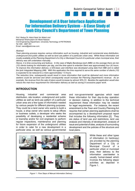
<strong>Buletin</strong> <strong>Geospatial</strong> <strong>Sektor</strong> <strong>Awam</strong> | 24Development of A User Interface ApplicationFor Information Delivery System – A Case Study ofIpoh City Council’s Department of Town PlanningProf. Madya Dr. Abdul Nasir bin Matori andMohamad Shahrustami bin Mohd NadzeriCivil Engineering Department, University Technology of PETRONASTel: 605 - 3687 291Email: nasrat@petronas.comAbstractTown planning process requires various information such as housing, industrial and commercial area distribution,underground and public utilities as well as land use pattern of a particular urban area. While these information aremostly available at the Planning Department of a City or Municipal Council of a particular urban municipal area, theirdelivery was still undertaken manually.Hence, it is time-consuming and tedious. In the case of Majlis Bandaraya Ipoh (MBI) on the average there are ten(10) clients looking for information per day, and the time spent to entertain them was approximately four (4) hours.To improve this information delivery, a GIS-base user-interface was developed using data from MBI and is calledthe Ipoh Integrated Mapping (IIM). With this application the time required to serve the same number of clients (10)is expected to be reduced to a mere approximately 1.5 hours.The reduction time, subsequently would result in more information that could be delivered and more informationseekers could be serviced and which consequently would increase the Planning Department’s revenue. As anexample, the revenue from the sale of plans would increase by almost 30% [1]. Besides the application would alsoreduce the man-hour requirement for information delivery as well as saving in excessive paper work.INTRODUCTIONHousing, industrial and commercial areadistribution, site location, underground and publicutilities as well as land-use pattern of a particularurban area are a few types of information neededby various people for different planning purposes.They could be a land owner who wants to build ahouse, a shop owner who wants to setup officesor business outlets, a developer who seeks thepossibility of developing a residential schemeor township and/or for civil engineers to performregular inspections, maintenance and planningfor future expansion of the underground utilitiesin order to cater for a new development in aparticular area, as well as various governmentaland non-governmental agencies which needthese information for their day-to-day operationor decision making. in addition to the technicalrequirement these information may be neededfor legal requirements. For instance, the recentamendment to the Town and Country Planning Actrequires that certain planning applications shall beaccompanied by a development proposal reportthat includes the following information [2]. Theyare status of land use and restrictions, land useanalysis and intensity of development, analysis ofissue and potential of sites, analysis of surroundingdevelopment and the policies of the structure andlocal plans.While these and other typesof information (in hardcopy)are provided by the planningDepartment of a City orMunicipal Council of aparticular urban or municipalarea, their delivery to theinformation user/seeker isusually human-based whichinvolves the following steps/activities as depicted inFigure 1.Figure 1 : Flow Steps of Manual Information Delivery


