

Buletin Geospatial Sektor Awam - Bil 1/ 2007 - Malaysia Geoportal
Buletin Geospatial Sektor Awam - Bil 1/ 2007 - Malaysia Geoportal
Buletin Geospatial Sektor Awam - Bil 1/ 2007 - Malaysia Geoportal
- No tags were found...

You also want an ePaper? Increase the reach of your titles
YUMPU automatically turns print PDFs into web optimized ePapers that Google loves.
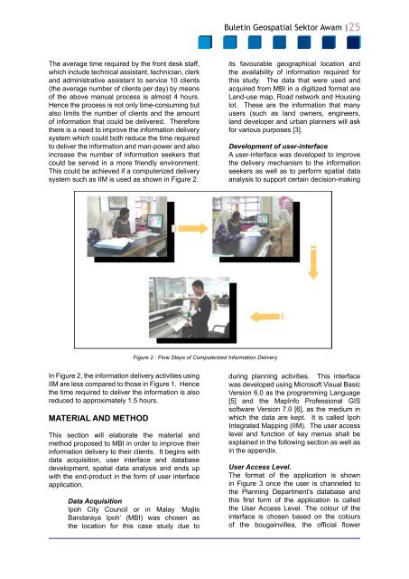
<strong>Buletin</strong> <strong>Geospatial</strong> <strong>Sektor</strong> <strong>Awam</strong> |25The average time required by the front desk staff,which include technical assistant, technician, clerkand administrative assistant to service 10 clients(the average number of clients per day) by meansof the above manual process is almost 4 hours.Hence the process is not only time-consuming butalso limits the number of clients and the amountof information that could be delivered. Thereforethere is a need to improve the information deliverysystem which could both reduce the time requiredto deliver the information and man-power and alsoincrease the number of information seekers thatcould be served in a more friendly environment.This could be achieved if a computerized deliverysystem such as IIM is used as shown in Figure 2.its favourable geographical location andthe availability of information required forthis study. The data that were used andacquired from MBI in a digitized format areLand-use map, Road network and Housinglot. These are the information that manyusers (such as land owners, engineers,land developer and urban planners will askfor various purposes [3].Development of user-interfaceA user-interface was developed to improvethe delivery mechanism to the informationseekers as well as to perform spatial dataanalysis to support certain decision-makingFigure 2 : Flow Steps of Computerized Information DeliveryIn Figure 2, the information delivery activities usingIIM are less compared to those in Figure 1. Hencethe time required to deliver the information is alsoreduced to approximately 1.5 hours.MATERIAL AND METHODThis section will elaborate the material andmethod proposed to MBI in order to improve theirinformation delivery to their clients. It begins withdata acquisition, user interface and databasedevelopment, spatial data analysis and ends upwith the end-product in the form of user interfaceapplication.Data AcquisitionIpoh City Council or in Malay ‘MajlisBandaraya Ipoh’ (MBI) was chosen asthe location for this case study due toduring planning activities. This interfacewas developed using Microsoft Visual BasicVersion 6.0 as the programming Language[5] and the MapInfo Professional GISsoftware Version 7.0 [6], as the medium inwhich the data are kept. It is called IpohIntegrated Mapping (IIM). The user accesslevel and function of key menus shall beexplained in the following section as well asin the appendix.User Access Level.The format of the application is shownin Figure 3 once the user is channeled tothe Planning Department’s database andthis first form of the application is calledthe User Access Level. The colour of theinterface is chosen based on the coloursof the bougainvillea, the official flower


