

Buletin Geospatial Sektor Awam - Bil 1/ 2007 - Malaysia Geoportal
Buletin Geospatial Sektor Awam - Bil 1/ 2007 - Malaysia Geoportal
Buletin Geospatial Sektor Awam - Bil 1/ 2007 - Malaysia Geoportal
- No tags were found...

You also want an ePaper? Increase the reach of your titles
YUMPU automatically turns print PDFs into web optimized ePapers that Google loves.
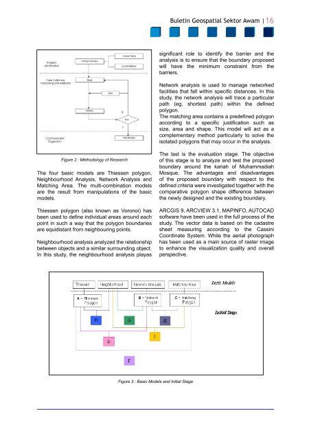
<strong>Buletin</strong> <strong>Geospatial</strong> <strong>Sektor</strong> <strong>Awam</strong> |16significant role to identify the barrier and theanalysis is to ensure that the boundary proposedwill have the minimum constraint from thebarriers.Network analysis is used to manage networkedfacilities that fall within specific distances. In thisstudy, the network analysis will trace a particularpath (eg. shortest path) within the definedpolygon.The matching area contains a predefined polygonaccording to a specific justification such assize, area and shape. This model will act as acomplementary method particularly to solve theisolated polygons that may occur in the analysis.Figure 2 : Methodology of ResearchThe four basic models are Thiessen polygon,Neighbourhood Analysis, Network Analysis andMatching Area. The multi-combination modelsare the result from manipulations of the basicmodels.Thiessen polygon (also known as Voronoi) hasbeen used to define individual areas around eachpoint in such a way that the polygon boundariesare equidistant from neighbouring points.Neighbourhood analysis analyzed the relationshipbetween objects and a similar surrounding object.In this study, the neighbourhood analysis playasThe last is the evaluation stage. The objectiveof this stage is to analyze and test the proposedboundary around the kariah of MuhammadiahMosque. The advantages and disadvantagesof the proposed boundary with respect to thedefined criteria were investigated together with thecomparative polygon shape difference betweenthe newly designed and the existing boundary.ARCGIS 9, ARCVIEW 3.1, MAPINFO, AUTOCADsoftware have been used in the full process of thestudy. The vector data is based on the cadastresheet measuring according to the CassiniCoordinate System. While the aerial photographhas been used as a main source of raster imageto enhance the visualization quality and overallperspective.Figure 3 : Basic Models and Initial Stage


