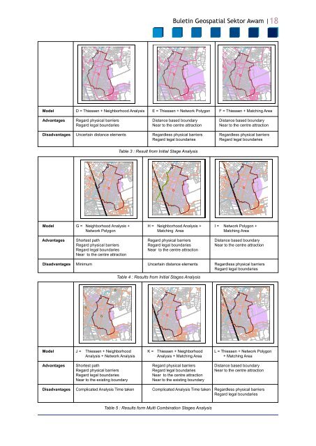
<strong>Buletin</strong> <strong>Geospatial</strong> <strong>Sektor</strong> <strong>Awam</strong> |18öööööööööModel D = Thiessen + Neighborhood Analysis E = Thiessen + Network Polygon F = Thiessen + Matching AreaAdvantages Regard physical barriers Distance based boundary Distance based boundaryRegard legal boundaries Near to the centre attraction Near to the centre attractionDisadvantages Uncertain distance elements Regardless physical barriers Regardless physical barriersRegard legal boundariesRegard legal boundariesöTable 3 : Result from Initial Stage AnalysisööööööööööModel G = Neighborhood Analysis + H = Neighborhood Analysis + I = Network Polygon +Network Polygon Matching Area Matching AreaAdvantages Shortest path Regard physical barriers Distance based boundaryRegard physical barriers Regard legal boundaries Near to the centre attractionRegard legal boundariesNear to the centre attractionNear to the centre attractionDisadvantages Minimum Uncertain distance elements Regardless physical barriersRegard legal boundariesTable 4 : Results from Initial Stages AnalysisööööööööööModel J = Thiessen + Neighborhood K = Thiessen + Neighborhood L = Thiessen + Network PolygonAnalysis + Network Analysis Analysis + Matching Area + Matching AreaAdvantages Shortest path Regard physical barriers Distance based boundaryRegard physical barriers Regard legal boundaries Near to the centre attractionRegard legal boundariesNear to the centre attractionNear to the existing boundaryNear to the existing boundaryDisadvantages Complicated Analysis Time taken Complicated Analysis Time taken Regardless physical barriersRegard legal boundariesTable 5 : Results form Multi Combination Stages Analysis
<strong>Buletin</strong> <strong>Geospatial</strong> <strong>Sektor</strong> <strong>Awam</strong> |19ööövii.S. Eagleson, F. Escobar and I. Williamson,2003. “Automating the administrationboundary design process using hierarchicalspatial reasoning theory and geographicinformation systems,” http://www.geom.unimelb.edu.au/research/SDI.research/publications/publilgis.php, Access:December 2004.REFERENCESi. Anna Katz, 2002. “Using GIS to evaluateredistricting plans,” http://www.aceproject.org/main/english/et/etk02.htm, Access:December 2004.ii.iii.iv.ModelAdvantagesDisadvantagesM = Thiessen + NeighborhoodAnalysis + Network Analysis+ Matching AreaShortest pathRegard physical barriersRegard legal boundariesNear to the centre attractionNear to the existing boundaryMinimumTable 6 : Multi Combination StageGian Gandi, Noreen Fairweather and MyrtlePalacio, 2004. “Boundary delimitationBelize”.Task Force. http://www.belizeelections.org/bound_delimitations.pdf.Access:Jun 2005.Gunnar Thorvaldsen, 2004. “On boundariesand areas in local history research,” http:///www.rhd.uit.no/census/boundaries.htm,Access: July 2004.JUPEM, 2005. ” Sambutan Ulang Tahun ke-120”. Penerbitan Khas.v. Peter Smailes, 1997. “Better spatial unitsfor Australian Rural research: The urgentneed for revision of the Australian standardgeographical classification,” 1997.viii.Shuib Daud, 2003. Group Discussion Note.UPELS, UiTM Perlis.ix. Zakaria Mat Arof, 2002. “Design aCollaborative Spatial Decision SupportSystem for Land Development Approval “.Phd Thesis. Unpublished. USM.10 TIPS OF ICT SECURITYIN MyGDI1. Protect your personal information and knowwho you are dealing with. Do not revealinformation about yourself to people orwebsites you do not know on the internet.2. Create hard-to-guess passwords and keepthem private.3. Don’t open emails from unknown sources.4. Use anti-virus, anti-spyware and keep themupdated regularly.5. Update your operating system and webbrowser regularly.6. Know the dangers of using File sharingor Peer-to-peer (P2P) systems as it maycontain spyware and viruses. It can alsocreate legal and ethical issues regardingthe unauthorized sharing of copyrightedmaterials.7. Back up your important files regularly.8. Don’t leave your computer unattended andpassword protect it when not in used.9. Never reveal your true identity in chatrooms.vi.S. Eagleson, F. Escobar and I. Williamson,1999. “Spatial hierarchical reasoning appliedto administrative boundary design usingGIS,” presented at 6th South East AsianSurveyor Congress, Fremantle, 1999.10. Contact helpdesk@macgdi.gov.my for anysecurity incidents while accessing MyGDIand MyCERT if something goes wrongonline.ria@macgdi.gov.myKKICT Section of MaCGDI