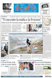
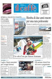
4 IL CAFFÈ 3 maggio 2009 Inferiore a 80 cm 120 – 200 cm 200 – 300 cm Su<strong>per</strong>iore a 300 La neve in Svizzera Altezza della neve a 2000 metri PAOLO MILLEMACI, geologo Giubiasco, Vedeggio, Val <strong>di</strong> Soi, Frasco, Preonzo, Chironico ... ecco alcuni luoghi del Ticino esposti al <strong>per</strong>icolo naturale. Dopo la valanga in Valle Bedretto e lo smottamento che ha investito Morcote, il Caffè traccia la mappa delle zone a rischio frane ed esondazioni nel Cantone. Qualche settimana fa gli es<strong>per</strong>ti federali hanno lanciato il preallarme alluvione, soprattutto nella Svizzera tedesca. In Ticino c’è ancora molta neve, soprattutto alle quote più alte, ma ciònonostante, grazie alla morfologia del territorio, la Svizzera italiana è maggiormente al riparo da alluvioni o straripamenti <strong>di</strong> fiumi. Inoltre, le autorità sembrano avere la situa- zione dei corsi d’acqua sotto controllo con una mappatura quasi completata, un monitoraggio dei luoghi più a rischio e sistemi <strong>di</strong> allarme ed evacuazione preparati, appunto, dagli es<strong>per</strong>ti cantonali. La popolazione ricorda ancora il <strong>di</strong>sastro, del 13 luglio 2008 a Giubiasco, quando i torrenti Vallascia e Fossato, straripati a seguito <strong>di</strong> un temporale anomalo, provocarono paura e danni ingenti. Ci fu anche una vittima a Biasca <strong>per</strong> un dramma simile nell’ottobre <strong>di</strong> <strong>due</strong> anni fa. Si calcola che in trent’anni, tra il 1972 e il 2002, la fattura <strong>per</strong> allagamenti, frane e colate <strong>di</strong> fango è stata <strong>di</strong> 1,8 <strong>miliar<strong>di</strong></strong> <strong>di</strong> <strong>franchi</strong>. Fenomeni abbastanza usuali nel Ticino <strong>per</strong> l’elevata piovosità e le caratteristiche geologiche del territorio. Proprio <strong>per</strong> questo ogni anno vengono eseguiti <strong>di</strong>versi progetti <strong>di</strong> “premunizione” <strong>per</strong> ridurre il grado <strong>di</strong> <strong>per</strong>icolo; là dove il rischio è elevato si giunge anche a vietare lo sviluppo <strong>di</strong> nuovi inse<strong>di</strong>amenti <strong>per</strong> la popolazione. E la situazione non tende certo a migliorare. Anzi. I dati sulle precipitazioni - raccolti ed elaborati da Meteo Svizzera - evidenziano come lungo il versante Sudalpino vi è stato, negli ultimi decenni, un aumento dell’intensità delle piogge con conseguente estremizzazione degli eventi atmosferici. D’altro canto il territorio cantonale ricade in una delle aree più piovose della Svizzera. Tutte le <strong>per</strong>turbazioni provenienti da sud terminano la loro corsa contro la catena alpina. Il Ticino sembra essere attrezzato a fronteggiare l’allarme maltempo, da anni esiste un LA MAPPA DEI PERICOLI Con l’inizio della stagione delle piogge, scattano gli allarmi <strong>per</strong> le aree più insicure. Mentre dal Cantone assicurano che... La frana <strong>di</strong> Chironico Ha un volume <strong>di</strong> 600.000 mila metricubi e si sposta fino a 10 cm all’anno. Minaccia limitatamente Chironico. A scadenza semestrale si esegue il controllo dei movimenti La valle Rovana si sposta Il fianco sinistro della valle si muove da 2 a <strong>di</strong>versi cm al mese con franamenti che minacciano Cerentino. Eseguiti un canale <strong>per</strong> raccogliere le acque <strong>di</strong> su<strong>per</strong>ficie e interventi forestali 196 km Su<strong>per</strong>ficie interessata dalle valanghe 2 342 km Su<strong>per</strong>ficie interessata dalle frane 2 E la terra ci frana da sotto i pie<strong>di</strong>, ecco le zone a rischio idrogeologico censimento dei <strong>per</strong>icoli naturali e delle situazioni più a rischio <strong>per</strong> la popolazione. “È stato il primo Cantone, già nel 1990, a dotarsi <strong>di</strong> una legge specifica sui <strong>per</strong>icoli naturali - spiega l’ingegnere Andrea Salvetti, dell’Ufficio corsi d’acqua -. Entro il 2011 saranno completate le carte delle <strong>per</strong>icoli <strong>di</strong> tutta la Sviz- Le piene nella Val Soi Il <strong>per</strong>icolo riguarda la formazione <strong>di</strong> colate detritiche innescate dalle intense precipitazioni. Minacciata la strada comunale Torre-Dangio e alcuni e<strong>di</strong>fici. È stato pre<strong>di</strong>sposto un sistema <strong>di</strong> monitoraggio e <strong>di</strong> allarme La valanga <strong>di</strong> Frasco La valanga ha raggiunto Frasco nel 1951 e potrebbe rifarlo. Installati apparecchi <strong>per</strong> rilevare lo strato nevoso. Attivato un piano <strong>di</strong> sicurezza che prevede l’evacuazione Piene del Lago Verbano Esondazione dei comuni rivieraschi, in particolare <strong>di</strong> Locarno. Eseguiti: nel 2006 la mappa “zone esondazione”, interventi sulle abitazioni a rischio e un sistema Su<strong>per</strong>ficie <strong>di</strong> allerta interessata dagli alluvionamenti 67 km 2 15% la su<strong>per</strong>ficie <strong>di</strong> inse<strong>di</strong>amento toccata da <strong>per</strong>icoli naturali “Finora abbiamo realizzato circa il 70% dei Piani delle Zone <strong>di</strong> <strong>per</strong>icolo della regione” zera, concernenti le piene dei corsi d’acqua, le valanghe, le frane e i processi relativi alla caduta <strong>di</strong> massi”. E <strong>per</strong> quanto riguarda le carte <strong>per</strong> le piene dei corsi d’acqua, dovremmo essere a buon punto: “In Ticino abbiamo realizzato circa il 70% dei Piani delle Zone <strong>di</strong> Pericolo”. Il lavoro <strong>di</strong> vigilanza degli inge- gneri è costante, così pure gli interventi sui corsi d’acqua. E <strong>per</strong> i prossimi anni <strong>di</strong>versi lavori sono già in cantiere. “Sono previsti interventi lungo i fiumi Cassarate, Laveggio e Vedeggio - aggiunge Salvetti -. Lungo il fiume Ticino è stata recentemente aumentata l’altezza degli argini nella tratta Bellinzona e Sementina”. @ www.ti.ch www.meteosvizzera.ch L’intervista “Seicento chilometri quadrati <strong>di</strong> <strong>per</strong>icolo” Così si protegge la popolazione quando la montagna si muove Al momento attuale le aree più <strong>per</strong>icolose in Ticino sono le frane <strong>di</strong> Cerentino, Preonzo, Chironico e Val Pontirone. Così la geologa Lorenza Re spiega come l’Ufficio <strong>per</strong>icoli naturali, incen<strong>di</strong> e progetti della Sezione forestale, gestisce questi problemi. La domanda sorge spontanea, quante <strong>per</strong>sone sono in <strong>per</strong>icolo? “Non è possibile sa<strong>per</strong>e quanta popo- lazione è effettivamente esposta al <strong>per</strong>icolo, <strong>per</strong>ché la situazione <strong>di</strong> potenziale <strong>per</strong>icolo è estremamente variabile e legata all'evoluzione nel tempo dell'attività del fenomeno”. Ma potete prevenire una frana? “Le <strong>di</strong>verse azioni <strong>di</strong> controllo, pre-allarme ed evacuazione vengono concretizzate al momento dell'emergere della crisi. I dati <strong>di</strong> fine 2008 in<strong>di</strong>cano La mappa dei luoghi più a rischio In val Pontirone la terra cede Dal 2006 la montagna si è spostata <strong>di</strong> tre metri, sotto c’è il nucleo <strong>di</strong> Biborgo. Interventi <strong>per</strong> stabilizzare la frana e drenare le acque in eccesso che globalmente il territorio esposto a <strong>per</strong>icolo ha una su<strong>per</strong>ficie <strong>di</strong> 600 chilometri quadri: il 31% concerne il <strong>per</strong>icolo valanghe, l’11% i fenomeni alluvionali e il 5% le frane. Rispetto alla su<strong>per</strong>ficie occupata stabilmente dagli inse<strong>di</strong>amenti umani (pari al 4% della su<strong>per</strong>ficie totale del Cantone) le zone <strong>di</strong> <strong>per</strong>icolo minacciano il 15% delle aree urbanizzate”. “ Le zone <strong>per</strong>icolose minacciano il 15% delle aree urbane. Ma la situazione è estremamente variabile e legata all’evoluzione dell’attività dei fenomeni” La frana <strong>di</strong> Preonzo Valanga <strong>di</strong> roccia <strong>di</strong> 1 milione <strong>di</strong> metricubi con movimento in accelerazione. Minacciate la zona industriale e la cantonale. Realizzate strutture <strong>di</strong> contenimento della frana Che cosa si sta facendo <strong>per</strong> minimizzare o eliminare il <strong>per</strong>icolo? “Grazie agli stu<strong>di</strong> <strong>di</strong> accertamento delle zone <strong>di</strong> <strong>per</strong>icolo avviati in Ticino da alcuni decenni e alla documentazione raccolta sugli eventi catastrofici storici (buzza <strong>di</strong> Biasca, frana <strong>di</strong> Peccia, <strong>di</strong> Campo Valle Maggia, del Motto d'Arbino, del Sasso Rosso, ecc.) la conoscenza su questo tipo <strong>di</strong> fenomeni Le precipitazioni durante l’anno Me<strong>di</strong>e mensili elaborate su trent’anni Gennaio 66 mm Febbraio 66 mm Marzo Aprile Maggio Giugno Luglio Agosto Settembre Ottobre Novembre Dicembre 79 mm Fonte: eurometeo.com / rilevamento 1961–1990 115 mm 153 mm 195 mm 182 mm 165 mm 184 mm 172 mm 183 mm 135 mm <strong>di</strong> instabilità è apprezzabile. Ha <strong>per</strong>messo da un lato la loro identificazione e dall'altro l'acquisizione <strong>di</strong> quegli elementi che ne consentono il controllo dell'attività. Di fronte infatti a movimenti <strong>di</strong> versante così imponenti è raro poter o<strong>per</strong>are con interventi <strong>di</strong> protezione strutturali (ve<strong>di</strong> sistemazione della frana <strong>di</strong> Campo Valle Maggia), mettendo cioè in atto o<strong>per</strong>e <strong>di</strong> stabilizzazione, proprio <strong>per</strong>ché confrontati con cause del <strong>di</strong>ssesto troppo estese o non sufficientemente conosciute e pure <strong>per</strong> questioni strettamente economiche”. Dunque quale soluzione resta? Si ricorre sostanzialmente a interventi <strong>di</strong> mitigazione del rischio non strutturali, ossia a sistemi <strong>di</strong> monitoraggio che da un lato consentono un approfon<strong>di</strong>mento delle conoscenze del fenomeno e dall'altro la gestione delle situazioni <strong>di</strong> emergenza”. Quin<strong>di</strong>, nessuna o<strong>per</strong>azione invasiva, ma tenete sotto controllo le zone a rischio... “Queste tecniche <strong>di</strong> monitoraggio mi- ALLUVIONE Un’immagine emblematica dell’alluvione che ha colpito Locarno nel 2000; qui sotto, la fuoriuscita del lago a Lugano nel 2002 E <strong>per</strong> i centri urbani attraversati da fiumi, se l’acqua dovesse tracimare chi avvisa la popolazione dei rischi? Questi sono i dubbi che, soprattutto nella stagione delle piogge, possono togliere il sonno a molte <strong>per</strong>sone. Ma l’ingegnere tranquillizza: “In tutti i paesi attraversati da corsi d’acqua, nel caso <strong>di</strong> evento eccezionale, autorità, polizia e protezione civile vigilano sull’evoluzione e se il caso lo richiede intervengono a tutela della popolazione”. Questo in teoria, ma in pratica, nei luoghi più a rischio, si sono introdotte anche misure più specifiche: “In alcuni comuni (Bedano, Biasca, Blenio), coinvolti da eventi ricorrenti, l’autorità comunale ha provveduto ad organizzare, o lo sta facendo, delle strutture <strong>di</strong> allerta, monitoraggio e piani <strong>di</strong> evacuazione - spiega in<strong>di</strong>cando come l’Ufficio corsi d’acqua abbia un ruolo importante -. Supporta la creazione <strong>di</strong> questi presi<strong>di</strong> territoriali, tramite la consulenza tecnica sui sistemi <strong>di</strong> monitoraggio, la definizione degli scenari attesi e altre in<strong>di</strong>cazioni utili <strong>per</strong> la pre<strong>di</strong>sposizione <strong>di</strong> un piano <strong>di</strong> allarme completo”. Intanto, tornando ai rischi <strong>per</strong> la popolazione, ai tempi <strong>di</strong> evacuazione non sembrano esserci tempi <strong>di</strong> reazione precisi. “La maggior parte dei bacini imbriferi ha una su<strong>per</strong>ficie ridotta e <strong>per</strong>tanto i tempi <strong>di</strong> risposta sono brevi - commenta -. Non è possibile generalizzare ed in<strong>di</strong>care delle precipitazioni <strong>per</strong>icolose, molto <strong>di</strong>pende anche dall’umi<strong>di</strong>tà del terreno e quin<strong>di</strong> dalle precipitazioni registrate nelle settimane o nei mesi precedenti”. rano essenzialmente a rilevare gli spostamenti in su<strong>per</strong>ficie (misure topografiche tra<strong>di</strong>zionali, apparecchi laser e radar) o in profon<strong>di</strong>tà, l'a<strong>per</strong>tura <strong>di</strong> fratture in su<strong>per</strong>ficie, le pressioni idrostatiche. In parallelo a questi sistemi che consentono il controllo dell'attività della frana possono essere monitorati anche altri parametri, come le precipitazioni, i deflussi, le portate delle sorgenti che <strong>per</strong>mettono <strong>di</strong> approfon<strong>di</strong>re le conoscenze sull'evoluzione del fenomeno e <strong>di</strong> fornire elementi utili alla pre<strong>di</strong>sposizione dell'allarme (ad esempio con la definizione <strong>di</strong> soglie <strong>di</strong> innesco)”. E quando qualcosa nella frana si dovesse muovere ? “Se una frana mostra segnali significativi <strong>di</strong> movimento, a livello cantonale e comunale ci si attiva <strong>per</strong> incrementare l'attività <strong>di</strong> controllo e monitoraggio e <strong>per</strong> pre<strong>di</strong>sporre opportuni piani <strong>di</strong> allarme ed evacuazione. È implicito che a fronte <strong>di</strong> fenomeni così estesi, in caso <strong>di</strong> forte attività l'obiettivo della sicurezza è mirato alla popolazione”.
$)&#! " ’-)%*++(. 011,