

GEOmedia_3_2016
La prima rivista italiana di geomatica
La prima rivista italiana di geomatica

You also want an ePaper? Increase the reach of your titles
YUMPU automatically turns print PDFs into web optimized ePapers that Google loves.
INTERGEO<br />
ers, which operated in staticrapid<br />
mode, were connected via<br />
Internet to NetGeo for a fine<br />
RTK positioning in the Italian<br />
reference system (ETRF 2000).<br />
The set of direct geo-referenced<br />
scanning stations also provided<br />
a pseudo GNSS network, able<br />
to act as a geodetic support.<br />
The collected point clouds were<br />
altogether 200, with an average<br />
spatial resolution of 100 mm in<br />
the useful range (10÷350) m;<br />
the computer storage has been<br />
globally around 26 GB.<br />
S. Pellegrino Terme, a small<br />
tourist settlement today, was<br />
very fashionable last century<br />
in the world of entrepreneurial<br />
bourgeoisie. The town is located<br />
along the narrow Brembo<br />
valley (north of the city of<br />
Bergamo): famous for the healing<br />
waters, it stands out in the<br />
local landscape with the undisputed<br />
charm of its architectures<br />
and the elegance of the urban<br />
environment.<br />
Among the artistic treasures,<br />
it must be remembered the<br />
municipal Club-House (1904-<br />
1906), with two towers reminiscent<br />
of the famous one in<br />
Monte Carlo (Principality of<br />
Monaco), and the impressive<br />
Grand Hotel (1904), along the<br />
Brembo river, with the large<br />
front full of decorations.<br />
The Grand Hotel is connected<br />
to the Club-House and the Spa<br />
buildings, located on the right<br />
bank of the river, through the<br />
bridge “Principe Umberto I”.<br />
All these structures were realized<br />
at the beginning of the<br />
nineteenth century in the<br />
years of Belle Époque and Art<br />
Nouveau.<br />
The terrestrial scanning survey<br />
was performed in a multi-level<br />
detail, ranging from OGC-<br />
LoD2 and OGC-LoD4, and<br />
corresponding to the scales<br />
from 1:500 to 1:100.<br />
A Faro laser scanner (Focus<br />
X330) was utilized, with a builtin<br />
photo-camera; this scanner,<br />
characterized by a long range<br />
(around 350 m), is particularly<br />
effective for 3D survey of large<br />
territorial spaces because it allows<br />
a meaningful reduction<br />
of the instrumental stations<br />
needed to capture information<br />
(see figures 3, 4, 5, 6).<br />
Good results were generally<br />
obtained, despite some deficiencies<br />
in the building-roof<br />
documentation, thanks to the<br />
favorable hilly morphology and<br />
the large range provided by the<br />
scanning device.<br />
The roof knowledge could be<br />
better realized through an additional<br />
survey from above, using<br />
UAS techniques.<br />
The other experience:<br />
the UAS survey of the<br />
Dehonian complex<br />
The religious complex of<br />
Dehonian fathers, is located in<br />
Albino, a small town in the valley<br />
of Serio, the river flowing<br />
down from the mountains surrounding<br />
Bergamo.<br />
This Apostolic school was<br />
built in 1910; during the years<br />
of World War II it became a<br />
kind of big ark hosting people<br />
evacuated from their homes<br />
and moved to Albino, which<br />
was considered safer from the<br />
bombing risk.<br />
In 1944 a part of the complex<br />
was occupied by the Italian military,<br />
who remained there until<br />
early 1945; during the war, the<br />
little town was bombed but the<br />
Apostolic school was luckily<br />
spared.<br />
In the following years, until<br />
1991, the structure served as<br />
Diocesan Seminary; when this<br />
activity ceased, the complex of<br />
buildings was renovated to create<br />
a meeting point for spirituality<br />
(fig. 7), still active.<br />
The imaging survey (using a<br />
hexa-copter) aimed to provide a<br />
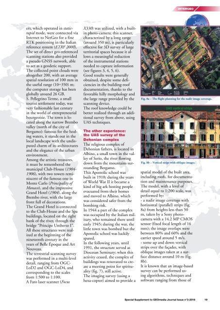
Fig. 8a – The flight planning for the nadir image coverage.<br />
Fig. 8b – Vertical strips with oblique images.<br />
spatial model of the built area,<br />
including roofs, for documentation<br />
and maintenance purposes.<br />
The model, with a level of<br />
detail equal to 1:200 scale, was<br />
performed by:<br />
- a nadir image coverage with<br />
horizontal (parallel) strips (fig.<br />
8a) from heights less than 50<br />
m, taken by a Sony photocamera<br />
with a 14.2 MP CMOS<br />
sensor (fixed focal length of 16<br />
mm); the image overlaps were<br />
between 80% and 60% and the<br />
carrier speed around 5 m/s.<br />
- some up and down vertical<br />
strips over the façades, with<br />
oblique images taken at a surface<br />
distance around 10 m (fig.<br />
8b).<br />
It is known that an image-based<br />
survey can be performed using<br />
algorithms, techniques and<br />
software ranging from those of<br />
Special Supplement to <strong>GEOmedia</strong> Journal Issue n°3-<strong>2016</strong> 19


