

GEOmedia_3_2016
La prima rivista italiana di geomatica
La prima rivista italiana di geomatica

Create successful ePaper yourself
Turn your PDF publications into a flip-book with our unique Google optimized e-Paper software.
INTERGEO<br />
Considering these aspects,<br />
an approximation<br />
on the fuel models has<br />
been done. In particular, in<br />
Italy, the only achieved result is<br />
a regional classification of forest<br />
types, but it cannot be considered<br />
equally valid for the calculation<br />
of the danger indexes. The<br />
development of this issue would<br />
improve our capacity of fire forecasting<br />
and, consequently, in the<br />
fire-fighting management.<br />
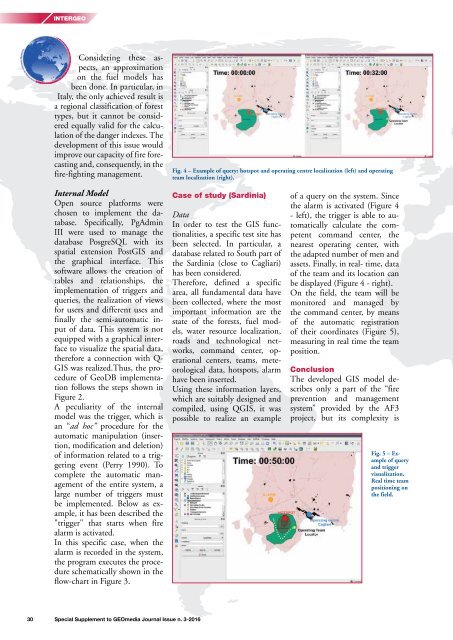
Fig. 4 – Example of query: hotspot and operating centre localization (left) and operating<br />
team localization (right).<br />
Internal Model<br />
Open source platforms were<br />
chosen to implement the database.<br />
Specifically, PgAdmin<br />
III were used to manage the<br />
database PosgreSQL with its<br />
spatial extension PostGIS and<br />
the graphical interface. This<br />
software allows the creation of<br />
tables and relationships, the<br />
implementation of triggers and<br />
queries, the realization of views<br />
for users and different uses and<br />
finally the semi-automatic input<br />
of data. This system is not<br />
equipped with a graphical interface<br />
to visualize the spatial data,<br />
therefore a connection with Q-<br />
GIS was realized.Thus, the procedure<br />
of GeoDB implementation<br />
follows the steps shown in<br />
Figure 2.<br />
A peculiarity of the internal<br />
model was the trigger, which is<br />
an “ad hoc” procedure for the<br />
automatic manipulation (insertion,<br />
modification and deletion)<br />
of information related to a triggering<br />
event (Perry 1990). To<br />
complete the automatic management<br />
of the entire system, a<br />
large number of triggers must<br />
be implemented. Below as example,<br />
it has been described the<br />
"trigger" that starts when fire<br />
alarm is activated.<br />
In this specific case, when the<br />
alarm is recorded in the system,<br />
the program executes the procedure<br />
schematically shown in the<br />
flow-chart in Figure 3.<br />
Case of study (Sardinia)<br />
Data<br />
In order to test the GIS functionalities,<br />
a specific test site has<br />
been selected. In particular, a<br />
database related to South part of<br />
the Sardinia (close to Cagliari)<br />
has been considered.<br />
Therefore, defined a specific<br />
area, all fundamental data have<br />
been collected, where the most<br />
important information are the<br />
state of the forests, fuel models,<br />
water resource localization,<br />
roads and technological networks,<br />
command center, operational<br />
centers, teams, meteorological<br />
data, hotspots, alarm<br />
have been inserted.<br />
Using these information layers,<br />
which are suitably designed and<br />
compiled, using QGIS, it was<br />
possible to realize an example<br />
of a query on the system. Since<br />
the alarm is activated (Figure 4<br />
- left), the trigger is able to automatically<br />
calculate the competent<br />
command center, the<br />
nearest operating center, with<br />
the adapted number of men and<br />
assets. Finally, in real- time, data<br />
of the team and its location can<br />
be displayed (Figure 4 - right).<br />
On the field, the team will be<br />
monitored and managed by<br />
the command center, by means<br />
of the automatic registration<br />
of their coordinates (Figure 5),<br />
measuring in real time the team<br />
position.<br />
Conclusion<br />
The developed GIS model describes<br />
only a part of the “fire<br />
prevention and management<br />
system” provided by the AF3<br />
project, but its complexity is<br />
Fig. 5 – Example<br />
of query<br />
and trigger<br />
visualization.<br />
Real time team<br />
positioning on<br />
the field.<br />
30 Special Supplement to <strong>GEOmedia</strong> Journal Issue n. 3-<strong>2016</strong>


