

GEOmedia_3_2016
La prima rivista italiana di geomatica
La prima rivista italiana di geomatica

Create successful ePaper yourself
Turn your PDF publications into a flip-book with our unique Google optimized e-Paper software.
INTERGEO<br />
GIS and fire-fighting: a<br />
brief description of the<br />
European scenario<br />
Currently, in Europe there are<br />
already several GIS useful for decision<br />
support at different stages<br />
of fire management. However,<br />
the opportunity to have both<br />
updated or real-time data, and<br />
a complete and consistent information,<br />
is often missing. Especially<br />
it is difficult to have an<br />
actual data interoperability with<br />
the existing available technologies.<br />
In most cases, the information<br />
collected in the GIS are incomplete<br />
and they concern only<br />
one phase of the overall management<br />
process. There are, indeed,<br />
systems used, exclusively,<br />
for prediction or for planning or<br />
emergency control. In this way, a<br />
lot of information is lost. However,<br />
this historical information<br />
could be helpful to make more<br />
comprehensive the tool for decision<br />
support. Furthermore, it<br />
lacks a central system to register<br />
distribution and availability of<br />
resources in risk periods, standardized<br />
systems for fires registry<br />
and systematic registration systems<br />
of firefighting operations.<br />
Finally, the metadata of the observed<br />
maps are not always available<br />
and the data validity is impossible<br />
to be determined.<br />
For example, in Europe, Web-<br />
GIS known as EFFIS (European<br />
Forest Fire Information System<br />
http://forest.jrc.ec.europa.eu/effis/)<br />
was developed by the JRC<br />
(Joint Research Centre). This<br />
GeoDB, still under construction,<br />
records only the data related<br />
to fire risk analysis and the<br />
occurred fires in Europe.<br />
Description of the GIS in AF3<br />
In order to propose an innovative<br />
GIS platform devoted to<br />
support the big forest fires management,<br />
the following activities<br />
must be considered: forecasting,<br />
monitoring, planning, active<br />
fight and post-fire practices.<br />
Nowadays, the modern system is<br />
not designed for a specific enduser<br />
and it stands out for its versatility.<br />
However, it is possible to<br />
establish different authorization<br />
for different users and method<br />
of use.<br />
In order to realize the dedicated<br />
GIS for AF3, the traditional<br />
modelling process was followed.<br />
As well known, needs to pass<br />
from the complexity of the reality<br />
to a formal schema describing<br />
entities and tools used in<br />
fire-fighting operations.<br />
External Model<br />
The first step was the development<br />
of an external model. In<br />
this model, the useful information<br />
could be gathered in three<br />
categories of objects: the competent<br />
authorities (command), the<br />
objects to be protected (territory),<br />
the event and the ignition<br />
point (fire and hotspot) (Figure<br />
1). In the case of AF3, there<br />
is only one control center that<br />
handles local operations centers,<br />
the terrestrial and aerial troops.<br />
The command center (command<br />
center) is the national control<br />
center. Local operations centers<br />
(operating center) are in charge to<br />
monitor and to fill register of the<br />
fire cadaster and the mission report.<br />
Instead, the teams (operating<br />
team) take care of active fight<br />
on the field.<br />
Conceptual and<br />
Logical Model<br />
(INSPIRE oriented)<br />
Next steps are the definition<br />
of conceptual and logical models.<br />
Therefore, these stages consist<br />
in identification of entities,<br />
attributes, definition of relationships<br />
between the entities and<br />
the data formats. The INSPIRE<br />
directive, thus, provides fundamentals<br />
for completely defining<br />
the information layers closely<br />
related to the land description<br />
(e.g. digital terrain model and<br />
digital surface model), the event<br />
progression (e.g. time) and meteorological<br />
data (e.g. wind<br />
direction and speed, temperature,<br />
humidity). This European<br />
specification has a general nature,<br />
which needs to be suitably<br />
extended for adapting to the<br />
specific application. Some “ad<br />
hoc” entities are added in order<br />
to consider the data related to<br />
the command chain, fuel model<br />
and forest types definition (Burgan<br />
et al, 1998; Baskets 1999<br />
Baskets 2002; Han Shuting et al<br />
1987).<br />
Currently, it is necessary to<br />
highlight that in Italy, as in Europe,<br />
a systematic survey and<br />
monitoring of the forests are<br />
missing. Moreover, standardized<br />
methodology for the preparation<br />
of suitable fuel models does<br />
not exist.<br />
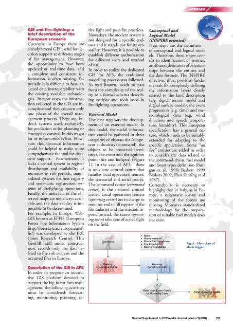
Fig. 3 – Flow-chart of<br />
alarm trigger.<br />
Special Supplement to <strong>GEOmedia</strong> Journal Issue n°3-<strong>2016</strong> 29


