


You also want an ePaper? Increase the reach of your titles
YUMPU automatically turns print PDFs into web optimized ePapers that Google loves.
REPORT<br />
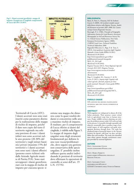
Fig.5 - Danni accertati georiferiti e mappe di<br />
impatto. Esempio per il cinghiale comprensorio<br />
di Lucca dal 2011 al 2015.<br />
BIBLIOGRAFIA<br />
Banti, P., Nuti, S., Ponzetta, M.P. & Sorbetti<br />
Guerri, F. (2009), Gli incidenti stradali causati<br />
dalla fauna selvatica nella Regione Toscana. Analisi<br />
del fenomeno nel periodo 2001-2008. Ed. Centro<br />
stampa Giunta Regionale Toscana.<br />
Burrough, P. A. (1986), Principles of Geographic<br />
Information Systems for Land Resource Assessment.<br />
Monographs on Soil and Resources Survey No.<br />
12, Oxford Science Publications, New York.<br />
European Environment Agency (2000),<br />
CORINE Land Cover, Technical Guidelines.<br />
Technical Addendum 2000<br />
Raganella Pelliccioni, E., Riga, F. & Toso, S.<br />
(2013), Linee guida per la gestione degli Ungulati.<br />
Manuali e Linee Guida ISPRA 91/2013<br />
(Retrieved: 01.09.<strong>2016</strong>)<br />
http://www.isprambiente.gov.it/files/<br />
pubblicazioni/manuali-lineeguida/<br />
MLG_91_2013.pdf<br />
(Retrieved: 01.09.<strong>2016</strong>)<br />
Regione Toscana (2012), Piano Regionale Agricolo<br />
Forestale 2012-2015. Regione Toscana<br />
http://www.regione.toscana.it/cittadini/<br />
alimentazione<br />
(Retrieved: 01.09.<strong>2016</strong>)<br />
Riga, F., Genghini, M., Cascone, C. & Di<br />
Luzio, P. (2011), Impatto degli Ungulati sulle<br />
colture agricole e forestali: proposta per linee<br />
guida nazionali. Manuali e Linee guida ISPRA<br />
68/2011.<br />
http://www.isprambiente.gov.it/files/<br />
pubblicazioni/manuali-lineeguida/10673_<br />
MLG_68_2011.pdf<br />
(Retrieved: 01.09.<strong>2016</strong>)<br />
Territoriali di Caccia (ATC).<br />
I danni accertati non sono stati<br />
inseriti come parametro diretto<br />
per la realizzazione delle mappe<br />
di rischio di impatto, poiché<br />
il dato non copre del tutto il<br />
territorio regionale ma solo<br />
una porzione di esso: i danni<br />
infatti non sono accertati nelle<br />
aree protette (20-30% del<br />
territorio) e negli istituti faunistici<br />
privati (massimo 15% del<br />
territorio) e i danni accertati<br />
non sono tutti i danni effettivi<br />
(possono essere richiesti solo<br />
dalle Aziende Agricole munite<br />
di Partita IVA). Sono stati<br />
sovrapposti i danni georeferenziati<br />
con la mappa di rischio di<br />
impatto per ciascuna specie: si<br />
ottiene una mappa che dimostra<br />
come la quasi totalità dei<br />
danni si concentrino nelle aree<br />
a massimo rischio di impatto.<br />
Il risultato, per il comprensorio<br />
di Lucca riferito ai danni del<br />
cinghiale, è visibile nella Figura 5.<br />
Le mappe di impatto degli<br />
ungulati sono degli strumenti<br />
fondamentali per definire le<br />
aree non vocate/problematiche,<br />
dove seguire una gestione<br />
non conservativa delle specie<br />
ungulate. E’ possibile inoltre<br />
raffinare questa analisi individuando<br />
le porzioni di territorio<br />
dove effettuare le operazioni di<br />
controllo ai sensi dell’art. 19<br />
L.N. 157/92.<br />
PAROLE CHIAVE<br />
GIS; gestione del rischio; pianificazione<br />
faunistica; area non vocata; interventi di<br />
controllo<br />
ABSTRACT<br />
Wild ungulates are widespread in almost all of the<br />
Italian peninsula. Their presence creates critical<br />
both to agricultural crops than to human structures.<br />
Proper wildlife territory planning can mitigate<br />
the problems present today. GIS tools can help<br />
in this process. It is possible through repeatable and<br />
objective measurable data to produce maps of potential<br />
impact of wild ungulates and guide management<br />
decisions through them. The study has<br />
produced maps of potential impact in the Tuscany<br />
territory for species: wild boar, roe deer, red deer,<br />
fallow deer and mouflon. The study also identified<br />
areas where operate through containment strategies<br />
provided by national legislation.<br />
AUTORE<br />
Dott. Alessandro Giugni<br />
giugni.alessandro7@gmail.com<br />
Dott. Marco Ferretti<br />
marco.ferretti@regione.toscana.it<br />
Regione Toscana<br />
Dott. Leonardo Conti<br />
leonardo.conti@unifi.it<br />
GESAAF Università degli Studi di Firenze<br />
<strong>GEOmedia</strong> n°6-<strong>2016</strong> 33


