- Page 1 and 2:
TOPOGRAFIE COSMIN CONSTANTIN MUŞAT
- Page 3 and 4:
1. ASPECTE GENERALE ALE MĂSURĂTOR
- Page 5 and 6:
PUNCTE TOPOGRAFICE Prin puncte cara
- Page 7 and 8:
DISTANŢA ORIZONTALĂ Este lungimea
- Page 9 and 10:
Coordonatele rectangulare se mai nu
- Page 11 and 12:
1.3. CERCUL TRIGONOMETRIC. CERCUL T
- Page 13 and 14:
În funcţie de acest unghi, funcţ
- Page 15 and 16:
2. HĂRŢI ŞI PLANURI TOPOGRAFICE
- Page 17 and 18:
2.3. SCĂRI TOPOGRAFICE Lungimile m
- Page 19 and 20:
Fig.2.4 - Scara grafică simplă cu
- Page 21 and 22:
zinc, aluminiu sau plastic. Pe aces
- Page 23 and 24:
2.5. CALCULUL SUPRAFEŢELOR Din pun
- Page 25 and 26:
trapeze formate de laturile exterio
- Page 27 and 28:
5cm 30-40cm punct matematic 20-25cm
- Page 29 and 30:
3.2. SEMNALIZAREA PUNCTELOR Semnali
- Page 31 and 32:
Piramida la sol - este o semnalizar
- Page 33 and 34:
Descrierea topografica a punctului
- Page 35 and 36:
Mărcile se încastrează în funda
- Page 37 and 38:
d. Teodolite-tahimetre, cu afişaj
- Page 39 and 40:
7. Luneta topografică, este un dis
- Page 41 and 42:
4.5. DISPOZITIVE DE CITIRE A UNGHIU
- Page 43 and 44:
c D 100 c Precizia scăriţei este
- Page 45 and 46:
- perfecţionarea centrării se fac
- Page 47 and 48:
Pentru alte unghiuri verticale care
- Page 49 and 50:
Transferul datelor măsurate şi me
- Page 51 and 52:
Utilizarea staţiei totale Leica TC
- Page 53 and 54:
Punerea în staţie a staţiei tota
- Page 55 and 56:
Modul de înregistrare a datelor m
- Page 57 and 58:
Măsurătorile geodezice prin unde,
- Page 59 and 60:
Procedeul de lucru cu tahimetrul el
- Page 61 and 62:
d. Metoda orientărilor directe, cu
- Page 63 and 64:
� În faza de birou, se calculeaz
- Page 65 and 66:
cazul înclinării lunetei sub oriz
- Page 67 and 68:
6.2. JALONAREA ALINIAMENTELOR Prin
- Page 69 and 70:
mai mari sau de formă elipsoidală
- Page 71 and 72:
În cazul aliniamentelor formate di
- Page 73 and 74:
Pentru a analiza propagarea erorilo
- Page 75 and 76:
Se va măsura o latură a unui triu
- Page 77 and 78:
Se aplică în cazul suprafeţelor
- Page 79 and 80:
a) Suma unghiurilor în triunghiuri
- Page 81 and 82:
sin �1 sin � 2 sin � 3 sin
- Page 83 and 84:
Se mai cunoaşte lungimea laturii C
- Page 85 and 86:
Adunând relaţiile (7.43) şi se o
- Page 87 and 88:
7.4.3. Compensarea unghiurilor tria
- Page 89 and 90:
Relaţiilor de mai sus li se impun
- Page 91 and 92:
Dezvoltând în serie Taylor sinusu
- Page 93 and 94:
Intersecţii laterale (combinate),
- Page 95 and 96:
(BP) Y - Y2 = tgθ2 (X - X2) (CP) Y
- Page 97 and 98:
8.2.3. Condiţii de aplicare pe ter
- Page 99 and 100:
Pentru a rezolva problema sunt de p
- Page 101 and 102: 1 - Cazul când patrulaterul ABCP e
- Page 103 and 104: În cazul acesta se va schimba dire
- Page 105 and 106: A(X ,Y ) � � � B(X , Y) �
- Page 107 and 108: Egalând relaţiile anterioare, vom
- Page 109 and 110: Intersecţia laterală cu orientare
- Page 111 and 112: Etape de calcul: 1. CALCULUL COORDO
- Page 113 and 114: Unghiurile orizontale calculate din
- Page 115 and 116: - combinaţia C - A X �tg�C �
- Page 117 and 118: Rezultă: �� X � �� Y IV
- Page 119 and 120: În multe situaţii, drumuirile se
- Page 121 and 122: � cu orientări magnetice, când
- Page 123 and 124: Măsurarea unghiurilor verticale Un
- Page 125 and 126: 9.2.3. Operaţiuni de birou pentru
- Page 127 and 128: 3. Calculul coordonatelor relative
- Page 129 and 130: 200 300 400 - schiţa drumuirii Eta
- Page 131 and 132: c cc c� � �e� � �1 16 c
- Page 133 and 134: - pentru " Y " Y Y �� y �1768
- Page 135 and 136: 3.Calculul orientărilor laturilor
- Page 137 and 138: iar în continuare se determină co
- Page 139 and 140: 10. NIVELMENTUL GEOMETRIC 10.1. NO
- Page 141 and 142: � Nivelmentul geometric de ordinu
- Page 143 and 144: Fig.10.2.Nivela clasică 1- luneta,
- Page 145 and 146: c. Nivele electronice digitale Pent
- Page 147 and 148: 10.4.5. Nivelmentul geometric de mi
- Page 149 and 150: Fig.10.6. Nivelmentul geometric de
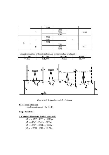
- Page 151: Operaţiunile se repetă până la
- Page 155 and 156: Se poate scrie: eh = valoarea erona
- Page 157 and 158: Figura 10.10 - Radieri de nivelment
- Page 159 and 160: Din figura (10.11) se observă că


![Buletinul {tiin]ific al Universit@]ii](https://img.yumpu.com/14905381/1/190x245/buletinul-tiinific-al-universitii-politehnica-din-timioa.jpg?quality=85)