Section 1 Introduction - National Marine Fisheries Service - NOAA
Section 1 Introduction - National Marine Fisheries Service - NOAA
Section 1 Introduction - National Marine Fisheries Service - NOAA

Create successful ePaper yourself
Turn your PDF publications into a flip-book with our unique Google optimized e-Paper software.
NBK at Bangor EHW-1 Pile Replacement Project Final <strong>Marine</strong> Mammal Monitoring Report<br />
Event<br />
Description<br />
Pile Coordinates Start Time Stop Time Sensor<br />
Measured Sound<br />
Pressure Level -<br />
RMS<br />
(WRA Boat)<br />
Ave Max<br />
Calculated distance to<br />
120 dB RMS (m)<br />
Date: 10/21/2011 (continued)<br />
W-3 -<br />
REVIB<br />
Lat.<br />
Long.<br />
47° 45.199'<br />
122° 43.448'<br />
15:37:01 15:39:51<br />
Mid<br />
Down<br />
821<br />
W-4 -<br />
REVIB<br />
Lat.<br />
Long.<br />
47° 45.199'<br />
122° 43.448'<br />
16:00:34 16:11:39<br />
Mid<br />
Down<br />
143<br />
145<br />
153<br />
154<br />
5,246<br />
W-5 -<br />
REVIB<br />
Lat.<br />
Long.<br />
47° 45.199'<br />
122° 43.448'<br />
16:13:55 16:16:47<br />
Mid<br />
Down<br />
150<br />
150<br />
153<br />
155<br />
5,199<br />
W-6 -<br />
REVIB<br />
Lat.<br />
Long.<br />
47° 45.199'<br />
122° 43.448'<br />
16:18:14 16:21:54<br />
Mid<br />
Down<br />
151<br />
153<br />
154<br />
155<br />
5,643<br />
Date: 10/27/2011<br />
W7 - REVIB<br />
Lat.<br />
Long.<br />
47° 45.199'<br />
122° 43.448'<br />
9:55:24 10:03:08<br />
Mid<br />
Down 160 161<br />
South ± 7,000 (Land)<br />
North ± 13,000 (Land)<br />
W9 - REVIB<br />
Lat.<br />
Long.<br />
47° 45.199'<br />
122° 43.448'<br />
10:05:17 10:08:51<br />
Mid<br />
Down 151 154<br />
South ± 7,000 (Land)<br />
North 10,400<br />
W12 -<br />
REVIB<br />
Lat.<br />
Long.<br />
47° 45.199'<br />
122° 43.448'<br />
10:12:52 10:18:33<br />
Mid<br />
Down 152 156<br />
South ± 7,000 (Land)<br />
North 12,000<br />
W11 -<br />
REVIB<br />
Lat.<br />
Long.<br />
47° 45.199'<br />
122° 43.448'<br />
10:21:04 10:26:12<br />
Mid<br />
Down 153 157<br />
South ± 7,000 (Land)<br />
North ± 13,000 (Land)<br />
EX3<br />
Lat.<br />
Long.<br />
47° 45.199'<br />
122° 43.448'<br />
11:24:13 11:25:58<br />
Mid<br />
Down<br />
145<br />
146<br />
147<br />
147<br />
4,706<br />
EX4<br />
Lat.<br />
Long.<br />
47° 45.199'<br />
122° 43.448'<br />
11:28:00 11:28:14<br />
Mid<br />
Down<br />
139<br />
140<br />
148<br />
148<br />
4,566<br />
EX3 - Cont.<br />
Lat.<br />
Long.<br />
47° 45.199'<br />
122° 43.448'<br />
11:31:00 11:31:18<br />
Mid<br />
Down<br />
142<br />
143<br />
142<br />
144<br />
2,754<br />
EX5<br />
Lat.<br />
Long.<br />
47° 45.199'<br />
122° 43.448'<br />
11:49:48 11:52:38<br />
Mid<br />
Down<br />
128<br />
128<br />
152<br />
151<br />
South ± 7,000 (Land)<br />
North 8,800<br />
EX6<br />
Lat.<br />
Long.<br />
47° 45.199'<br />
122° 43.448'<br />
11:58:49 12:02:13<br />
Mid<br />
Down<br />
128<br />
129<br />
151<br />
150<br />
South ± 7,000 (Land)<br />
North 7,700<br />
Notes:<br />
1 Pile was not driven. Hammer was setup on a permanent pile inside EHW-1, however, due to space limitations as a result of<br />
the tidal elevation the hammer could not be turned on and no pile driving occurred on October 4th;<br />
A RMS Sound levels during vibratory driving analyzed in 10 sec periods "Max" is the maximum level for any 10 second<br />
period "Avg" is the average of the 10 second periods over the duration of the pile driving event.<br />
B Based on best available data for each pile driving event<br />
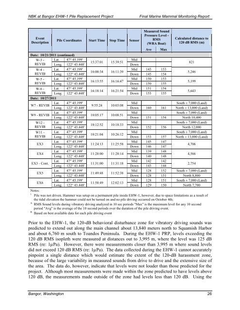
Prior to the EHW-1, the 120-dB behavioral disturbance zone for vibratory driving sounds was<br />
predicted to extend out along the main channel about 13,840 meters north to Squamish Harbor<br />
and about 6,760 m south to Toandos Peninsula. During the EHW-1 PRP, levels exceeding the<br />
120 dB RMS isopleth were measured at distances out to 3,995 m, where the level was 125 dB<br />
RMS (re: 1µPa). However, there were measurements closer than 3,995 m where sound levels<br />
did not exceed 120 dB RMS (re: 1µPa). The data collected during the EHW-1 cannot accurately<br />
pinpoint a single distance which would estimate the extent of the 120-dB harassment zone,<br />
because of the large variability in measured sounds from drive to drive and the extensive size of<br />
the area. The data do, however, indicate that levels were not louder than those predicted for the<br />
project. Although most measurements were made within the zone predicted to have levels above<br />
120 dB, the measurements made outside of the zone had levels less than 120 dB. Using the<br />
Bangor, Washington 26