Petaluma Bombing Target Archive Search Report ... - Corpsfuds.org
Petaluma Bombing Target Archive Search Report ... - Corpsfuds.org
Petaluma Bombing Target Archive Search Report ... - Corpsfuds.org

Create successful ePaper yourself
Turn your PDF publications into a flip-book with our unique Google optimized e-Paper software.
ARCHIVES SEARCH REPORT – FINDINGS<br />
<strong>Petaluma</strong> 12th Naval District <strong>Target</strong> No. 9<br />
<strong>Petaluma</strong>, CA<br />
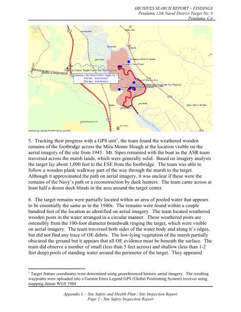
5. Tracking their progress with a GPS unit 1 , the team found the weathered wooden<br />
remains of the footbridge across the Mira Monte Slough at the location visible on the<br />
aerial imagery of the site from 1945. Mr. Sipes remained with the boat as the ASR team<br />
traversed across the marsh lands, which were generally solid. Based on imagery analysis<br />
the target lay about 1,000 feet to the ESE from the footbridge. The team was able to<br />
follow a wooden plank walkway part of the way through the marsh to the target.<br />
Although it approximated the path on aerial imagery, it was unclear if these were the<br />
remains of the Navy’s path or a reconstruction by duck hunters. The team came across at<br />
least half a dozen duck blinds in the area around the target center.<br />
6. The target remains were partially located within an area of pooled water that appears<br />
to be essentially the same as in the 1940s. The remains were found within a couple<br />
hundred feet of the location as identified on aerial imagery. The team located weathered<br />
wooden posts in the water arranged in a circular manner. These weathered posts are<br />
ostensibly from the 100-foot diameter boardwalk ringing the target, which were visible<br />
on aerial imagery. The team traversed both sides of the water body and along it’s edges,<br />
but did not find any trace of OE debris. The low-lying vegetation of the marsh partially<br />
obscured the ground but it appears that all OE evidence must be beneath the surface. The<br />
team did observe a number of small (less than 5 feet across) and shallow (less than 1-2<br />
feet deep) pools of standing water around the perimeter of the target. They appeared<br />
1 <strong>Target</strong> feature coordinates were determined using georeferenced historic aerial imagery. The resulting<br />
waypoints were uploaded into a Garmin Etrex Legend GPS (Global Positioning System) receiver using<br />
mapping datum WGS 1984<br />
Appendix L – Site Safety and Health Plan / Site Inspection <strong>Report</strong><br />
Page 2 - Site Safety Inspection <strong>Report</strong>