

STANDARD - Survey Instrument Antique Center!
STANDARD - Survey Instrument Antique Center!
STANDARD - Survey Instrument Antique Center!

You also want an ePaper? Increase the reach of your titles
YUMPU automatically turns print PDFs into web optimized ePapers that Google loves.
70<br />
Degree of Precision Required.<br />
(10.) This, of course, depends on the character of the work to be done. In the<br />
U. S. Public Land <strong>Survey</strong>s, which are, without question, conducted on the best plan<br />
the world can afford, only compass lines are required. As a consequence, a wide<br />
margin for non-precision is given.<br />
In<br />
t sub-dividing a block of townships, the surveyor in coursing a random of 6<br />
miles, is required to make his objective point within 3 chains. Charging the half<br />
of this error to lineal measurement, we find the error of coursing must be within 10*<br />
of the true course.<br />
(11. j In Manitoba, the authorities, having fallen in love uith our system of Public<br />
Land <strong>Survey</strong>s, have adopted it but ; they require greater precision. They require<br />
clear transit lines, projected with the best six-inch silver lined instruments,<br />
graduated to 10".<br />
In coursing a 6 mile random in the sub-division of a township, the surveyor<br />
must make his objective point within one chain, in order to save reviewing his work,<br />
charging, as before, one half of this error to the lineal measurements, we find the<br />
maximum error allowed in coursing to be between 3* and 4'.<br />
(12) With the " New Solar," as manufactured by Messrs. C. L. Berger & Sons,<br />
the surveyor will be surprised and delighted to see the facility and certainty with<br />
which he can bring his work far within the above limit.<br />
Inclination of the Meridian.<br />
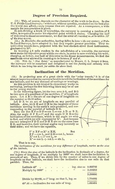
(13.) In projecting arcs of a great circle with the "solar transit," it is of ths<br />
utmost importance that the surveyorbe able to tell the inclination ofthe meridians for<br />
any latitude, and for any distance of eastings or westings.<br />
As this problem is not treated in elementary works on<br />
surveying, perhaps the few following hints may be of use<br />
to the young student.<br />
In the following figure, let the two arcs A G, and B G<br />
be two arcs of a quadrant of the meridian, 1 of longitude<br />
apart. Let A B = the arc of one degree of longitude on<br />
the equator = 69.16 miles.<br />
Let D E be an arc of longitude on any parallel of<br />
latitude. Also, let E H and D H be the tangents of those<br />
meridians meeting in the earth's axis produced, and corresponding<br />
to the parallel of latitude D E.<br />
Then the line E F= D F=cos L = cos A D or B E.<br />
Also, the angle D F E = l,and the angle D H E=the<br />
inclination of the meridians, which is the angle we wish<br />
to find, and which we will represent by X. And, because<br />
the two triangles F D E and D H E are on the same base<br />
E D, and isosceles, their vertical angles vary inversely as<br />
their sides ;<br />
and we have the equation,<br />
1XEF=XXEH,<br />
But<br />
E F = cos L, and E H= cot L, hence<br />
X cot L= l cos L, or<br />
X = cos L -4- cot L = sin L, (a)<br />
That is to say,<br />
The inclination of the meridians for any difference of longitude, varies as the sine<br />
of the latitude.<br />
(14.) Since the sine of the latitude is the inclination in decimals of a degree, for<br />
one degree of longitude, if we multiply by 3600" we shall have the inclination in<br />
seconds of arc. Then, if we divide this by the number of miles in one degree of<br />
longitude on that latitude, we shall have the inclination due to one mile on that<br />
parallel. Thus, for<br />
Latitude 43 log. sine = 9.833783<br />
Multiply by 3600"<br />
" = 3.556303<br />
Divide by 5066, = 1 long, on that L, log.<br />
4S".46 = inclination for one mile of long.<br />
3.390086<br />
1.704682<br />
1.685404