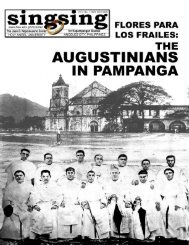
Download PDF - Holy Angel University
Download PDF - Holy Angel University
Download PDF - Holy Angel University

Create successful ePaper yourself
Turn your PDF publications into a flip-book with our unique Google optimized e-Paper software.
22<br />
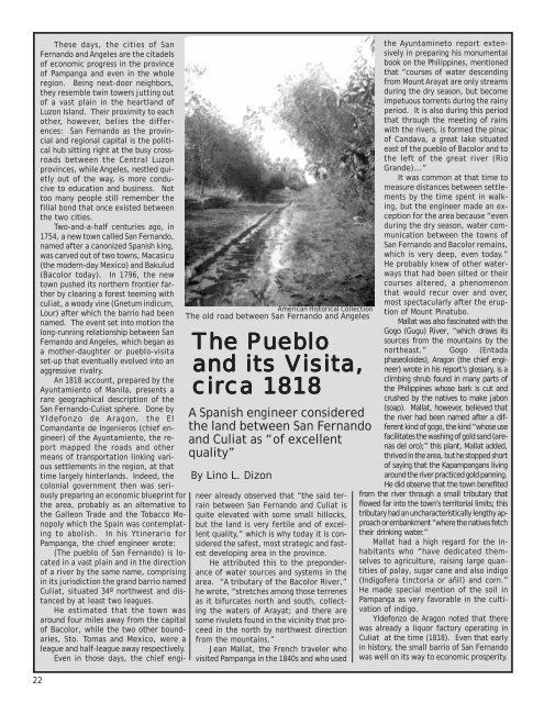
These days, the cities of San<br />
Fernando and <strong>Angel</strong>es are the citadels<br />
of economic progress in the province<br />
of Pampanga and even in the whole<br />
region. Being next-door neighbors,<br />
they resemble twin towers jutting out<br />
of a vast plain in the heartland of<br />
Luzon Island. Their proximity to each<br />
other, however, belies the differences:<br />
San Fernando as the provincial<br />
and regional capital is the political<br />
hub sitting right at the busy crossroads<br />
between the Central Luzon<br />
provinces, while <strong>Angel</strong>es, nestled quietly<br />
out of the way, is more conducive<br />
to education and business. Not<br />
too many people still remember the<br />
filial bond that once existed between<br />
the two cities.<br />
Two-and-a-half centuries ago, in<br />
1754, a new town called San Fernando,<br />
named after a canonized Spanish king,<br />
was carved out of two towns, Macasicu<br />
(the modern-day Mexico) and Bakulud<br />
(Bacolor today). In 1796, the new<br />
town pushed its northern frontier farther<br />
by clearing a forest teeming with<br />
culiat, a woody vine (Gnetum indicum,<br />
Lour) after which the barrio had been<br />
named. The event set into motion the<br />
long-running relationship between San<br />
Fernando and <strong>Angel</strong>es, which began as<br />
a mother-daughter or pueblo-visita<br />
set-up that eventually evolved into an<br />
aggressive rivalry.<br />
An 1818 account, prepared by the<br />
Ayuntamiento of Manila, presents a<br />
rare geographical description of the<br />
San Fernando-Culiat sphere. Done by<br />
Yldefonzo de Aragon, the El<br />
Comandante de Ingenieros (chief engineer)<br />
of the Ayuntamiento, the report<br />
mapped the roads and other<br />
means of transportation linking various<br />
settlements in the region, at that<br />
time largely hinterlands. Indeed, the<br />
colonial government then was seriously<br />
preparing an economic blueprint for<br />
the area, probably as an alternative to<br />
the Galleon Trade and the Tobacco Monopoly<br />
which the Spain was contemplating<br />
to abolish. In his Ytinerario for<br />
Pampanga, the chief engineer wrote:<br />
(The pueblo of San Fernando) is located<br />
in a vast plain and in the direction<br />
of a river by the same name, comprising<br />
in its jurisdiction the grand barrio named<br />
Culiat, situated 34º northwest and distanced<br />
by at least two leagues.<br />
He estimated that the town was<br />
around four miles away from the capital<br />
of Bacolor, while the two other boundaries,<br />
Sto. Tomas and Mexico, were a<br />
league and half-league away respectively.<br />
Even in those days, the chief engi-<br />
American Historical Collection<br />
The old road between San Fernando and <strong>Angel</strong>es<br />
The he Pue Pueblo Pue lo<br />
and and its its Visita isita isita, isita<br />
cir circa cir ca 1818<br />
1818<br />
A Spanish engineer considered<br />
the land between San Fernando<br />
and Culiat as “of excellent<br />
quality”<br />
By Lino L. Dizon<br />
neer already observed that “the said terrain<br />
between San Fernando and Culiat is<br />
quite elevated with some small hillocks,<br />
but the land is very fertile and of excellent<br />
quality,” which is why today it is considered<br />
the safest, most strategic and fastest<br />
developing area in the province.<br />
He attributed this to the preponderance<br />
of water sources and systems in the<br />
area. “A tributary of the Bacolor River,”<br />
he wrote, “stretches among those terrenes<br />
as it bifurcates north and south, collecting<br />
the waters of Arayat; and there are<br />
some rivulets found in the vicinity that proceed<br />
in the north by northwest direction<br />
from the mountains.”<br />
Jean Mallat, the French traveler who<br />
visited Pampanga in the 1840s and who used<br />
the Ayuntamineto report extensively<br />
in preparing his monumental<br />
book on the Philippines, mentioned<br />
that “courses of water descending<br />
from Mount Arayat are only streams<br />
during the dry season, but become<br />
impetuous torrents during the rainy<br />
period. It is also during this period<br />
that through the meeting of rains<br />
with the rivers, is formed the pinac<br />
of Candava, a great lake situated<br />
east of the pueblo of Bacolor and to<br />
the left of the great river (Rio<br />
Grande)….”<br />
It was common at that time to<br />
measure distances between settlements<br />
by the time spent in walking,<br />
but the engineer made an exception<br />
for the area because “even<br />
during the dry season, water communication<br />
between the towns of<br />
San Fernando and Bacolor remains,<br />
which is very deep, even today.”<br />
He probably knew of other waterways<br />
that had been silted or their<br />
courses altered, a phenomenon<br />
that would recur over and over,<br />
most spectacularly after the eruption<br />
of Mount Pinatubo.<br />
Mallat was also fascinated with the<br />
Gogo (Gugu) River, “which draws its<br />
sources from the mountains by the<br />
northeast.” Gogo (Entada<br />
phaseoloides), Aragon (the chief engineer)<br />
wrote in his report’s glossary, is a<br />
climbing shrub found in many parts of<br />
the Philippines whose bark is cut and<br />
crushed by the natives to make jabon<br />
(soap). Mallat, however, believed that<br />
the river had been named after a different<br />
kind of gogo, the kind “whose use<br />
facilitates the washing of gold sand (arenas<br />
del oro);” this plant, Mallat added,<br />
thrived in the area, but he stopped short<br />
of saying that the Kapampangans living<br />
around the river practiced gold panning.<br />
He did observe that the town benefited<br />
from the river through a small tributary that<br />
flowed far into the town’s territorial limits; this<br />
tributary had an uncharacteristically lengthy approach<br />
or embankment “where the natives fetch<br />
their drinking water.”<br />
Mallat had a high regard for the inhabitants<br />
who “have dedicated themselves<br />
to agriculture, raising large quantities<br />
of palay, sugar cane and also indigo<br />
(Indigofera tinctoria or añil) and corn.”<br />
He made special mention of the soil in<br />
Pampanga as very favorable in the cultivation<br />
of indigo.<br />
Yldefonzo de Aragon noted that there<br />
was already a liquor factory operating in<br />
Culiat at the time (1818). Even that early<br />
in history, the small barrio of San Fernando<br />
was well on its way to economic prosperity.