

Sockburn Hall, Darlington: an archaeological ... - English Heritage
Sockburn Hall, Darlington: an archaeological ... - English Heritage
Sockburn Hall, Darlington: an archaeological ... - English Heritage

Create successful ePaper yourself
Turn your PDF publications into a flip-book with our unique Google optimized e-Paper software.
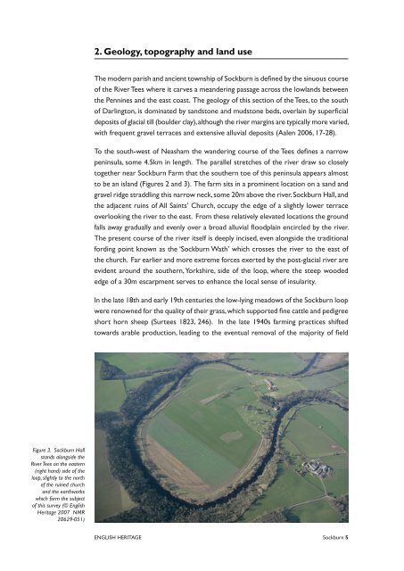
Figure 3. <strong>Sockburn</strong> <strong>Hall</strong><br />
st<strong>an</strong>ds alongside the<br />
River Tees on the eastern<br />
(right h<strong>an</strong>d) side of the<br />
loop, slightly to the north<br />
of the ruined church<br />
<strong>an</strong>d the earthworks<br />
which form the subject<br />
of this survey (© <strong>English</strong><br />
<strong>Heritage</strong> 2007 NMR<br />
20629-051)<br />
. Geology, topography <strong>an</strong>d l<strong>an</strong>d use<br />
The modern parish <strong>an</strong>d <strong>an</strong>cient township of <strong>Sockburn</strong> is defined by the sinuous course<br />
of the River Tees where it carves a me<strong>an</strong>dering passage across the lowl<strong>an</strong>ds between<br />
the Pennines <strong>an</strong>d the east coast. The geology of this section of the Tees, to the south<br />
of <strong>Darlington</strong>, is dominated by s<strong>an</strong>dstone <strong>an</strong>d mudstone beds, overlain by superficial<br />
deposits of glacial till (boulder clay),although the river margins are typically more varied,<br />
with frequent gravel terraces <strong>an</strong>d extensive alluvial deposits (Aalen 2006, 17-28).<br />
To the south-west of Neasham the w<strong>an</strong>dering course of the Tees defines a narrow<br />
peninsula, some 4.5km in length. The parallel stretches of the river draw so closely<br />
together near <strong>Sockburn</strong> Farm that the southern toe of this peninsula appears almost<br />
to be <strong>an</strong> isl<strong>an</strong>d (Figures 2 <strong>an</strong>d 3). The farm sits in a prominent location on a s<strong>an</strong>d <strong>an</strong>d<br />
gravel ridge straddling this narrow neck,some 20m above the river.<strong>Sockburn</strong> <strong>Hall</strong>,<strong>an</strong>d<br />
the adjacent ruins of All Saints’ Church, occupy the edge of a slightly lower terrace<br />
overlooking the river to the east. From these relatively elevated locations the ground<br />
falls away gradually <strong>an</strong>d evenly over a broad alluvial floodplain encircled by the river.<br />
The present course of the river itself is deeply incised, even alongside the traditional<br />
fording point known as the ‘<strong>Sockburn</strong> Wath’ which crosses the river to the east of<br />
the church. Far earlier <strong>an</strong>d more extreme forces exerted by the post-glacial river are<br />
evident around the southern,Yorkshire, side of the loop, where the steep wooded<br />
edge of a 30m escarpment serves to enh<strong>an</strong>ce the local sense of insularity.<br />
In the late 18th <strong>an</strong>d early 19th centuries the low-lying meadows of the <strong>Sockburn</strong> loop<br />
were renowned for the quality of their grass, which supported fine cattle <strong>an</strong>d pedigree<br />
short horn sheep (Surtees 1823, 246). In the late 1940s farming practices shifted<br />
towards arable production, leading to the eventual removal of the majority of field<br />
ENGLISH HERITAGE <strong>Sockburn</strong>


