

Sockburn Hall, Darlington: an archaeological ... - English Heritage
Sockburn Hall, Darlington: an archaeological ... - English Heritage
Sockburn Hall, Darlington: an archaeological ... - English Heritage

You also want an ePaper? Increase the reach of your titles
YUMPU automatically turns print PDFs into web optimized ePapers that Google loves.
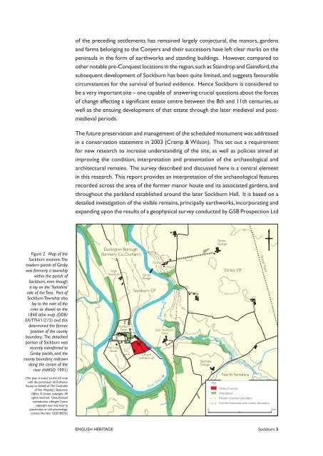
Figure 2. Map of the<br />
<strong>Sockburn</strong> environs. The<br />
modern parish of Girsby<br />
was formerly a township<br />
within the parish of<br />
<strong>Sockburn</strong>, even though<br />
it lay on the ‘Yorkshire’<br />
side of the Tees. Part of<br />
<strong>Sockburn</strong> Township also<br />
lay to the east of the<br />
river as shown on the<br />
1840 tithe map (DDR/<br />
EA/TTH/1/215) <strong>an</strong>d this<br />
determined the former<br />
position of the county<br />
boundary. The detached<br />
portion of <strong>Sockburn</strong> was<br />
recently tr<strong>an</strong>sferred to<br />
Girsby parish, <strong>an</strong>d the<br />
county boundary redrawn<br />
along the centre of the<br />
river (HMSO 1991)<br />
(This pl<strong>an</strong> is based on the OS map<br />
with the permission of Ordn<strong>an</strong>ce<br />
Survey on behalf of The Controller<br />
of Her Majesty’s Stationery<br />
Office, © Crown copyright. All<br />
rights reserved. Unauthorised<br />
reproduction infringes Crown<br />
copyright <strong>an</strong>d may lead to<br />
prosecution or civil proceedings.<br />
Licence Number: GD03085G)<br />
of the preceding settlements has remained largely conjectural, the m<strong>an</strong>ors, gardens<br />
<strong>an</strong>d farms belonging to the Conyers <strong>an</strong>d their successors have left clear marks on the<br />
peninsula in the form of earthworks <strong>an</strong>d st<strong>an</strong>ding buildings. However, compared to<br />
other notable pre-Conquest locations in the region,such as Staindrop <strong>an</strong>d Gainsford,the<br />
subsequent development of <strong>Sockburn</strong> has been quite limited, <strong>an</strong>d suggests favourable<br />
circumst<strong>an</strong>ces for the survival of buried evidence. Hence <strong>Sockburn</strong> is considered to<br />
be a very import<strong>an</strong>t site – one capable of <strong>an</strong>swering crucial questions about the forces<br />
of ch<strong>an</strong>ge affecting a signific<strong>an</strong>t estate centre between the 8th <strong>an</strong>d 11th centuries, as<br />
well as the ensuing development of that estate through the later medieval <strong>an</strong>d post-<br />
medieval periods.<br />
The future preservation <strong>an</strong>d m<strong>an</strong>agement of the scheduled monument was addressed<br />
in a conservation statement in 2003 (Cramp & Wilson). This set out a requirement<br />
for new research to increase underst<strong>an</strong>ding of the site, as well as policies aimed at<br />
improving the condition, interpretation <strong>an</strong>d presentation of the <strong>archaeological</strong> <strong>an</strong>d<br />
architectural remains. The survey described <strong>an</strong>d discussed here is a central element<br />
in this research. This report provides <strong>an</strong> interpretation of the <strong>archaeological</strong> features<br />
recorded across the area of the former m<strong>an</strong>or house <strong>an</strong>d its associated gardens, <strong>an</strong>d<br />
throughout the parkl<strong>an</strong>d established around the later <strong>Sockburn</strong> <strong>Hall</strong>. It is based on a<br />
detailed investigation of the visible remains, principally earthworks, incorporating <strong>an</strong>d<br />
exp<strong>an</strong>ding upon the results of a geophysical survey conducted by GSB Prospection Ltd<br />
40m<br />
30m<br />
20m<br />
<strong>Darlington</strong> Borough<br />
(formerly Co. Durham)<br />
High<br />
<strong>Sockburn</strong><br />
The Grey<br />
Stone<br />
50m<br />
<strong>Sockburn</strong><br />
Farm<br />
40m<br />
30m<br />
20m<br />
Girsby<br />
Bridge<br />
<strong>Sockburn</strong> CP<br />
<strong>Hall</strong><br />
Church<br />
(remains of)<br />
Girsby<br />
River Tees<br />
Church<br />
20m<br />
30m<br />
East <strong>Sockburn</strong><br />
Farm<br />
ENGLISH HERITAGE <strong>Sockburn</strong><br />
40m<br />
40m<br />
Staindale<br />
Gr<strong>an</strong>ge<br />
Key<br />
Girsby<br />
Gr<strong>an</strong>ge<br />
Girsby CP<br />
50m<br />
Staindale Beck<br />
40m<br />
North Yorkshire<br />
Area of survey<br />
Woodl<strong>an</strong>d<br />
Modern county boundary<br />
Rom<strong>an</strong> Road<br />
Former township <strong>an</strong>d county boundary<br />
0 1km


