

Sockburn Hall, Darlington: an archaeological ... - English Heritage
Sockburn Hall, Darlington: an archaeological ... - English Heritage
Sockburn Hall, Darlington: an archaeological ... - English Heritage

You also want an ePaper? Increase the reach of your titles
YUMPU automatically turns print PDFs into web optimized ePapers that Google loves.
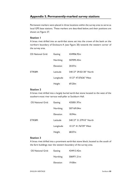
Appendix . Perm<strong>an</strong>ently-marked survey stations<br />
Perm<strong>an</strong>ent markers were placed in three locations within the survey area to serve as<br />
local GPS base stations. These markers are described below, <strong>an</strong>d their positions are<br />
shown on Figure 37.<br />
Station<br />
A brass rivet drilled into <strong>an</strong> earth-fast stone set into the crown of the b<strong>an</strong>k on the<br />
northern boundary of Enclosure A (see Figure 20) towards the western corner of<br />
the survey area.<br />
OS National Grid: Easting 434906.92m<br />
Northing 507095.43m<br />
Elevation 20.07m<br />
ETRS89: Latitude 540 27’ 29.02130” North<br />
Longitude 10 27’ 47.07636” West<br />
Height 69.20m<br />
Station<br />
A brass rivet drilled into a largely buried earth-fast stone located to the west of the<br />
southern-most river terrace wall-pillar at <strong>Sockburn</strong> <strong>Hall</strong>.<br />
OS National Grid: Easting 435001.97m<br />
Northing 507169.04m<br />
Elevation 18.94m<br />
ETRS89: Latitude 540 27’ 31.37910” North<br />
Longitude 10 27’ 41.76729” West<br />
Height 68.07m<br />
Station<br />
A brass rivet drilled into a prominent earth-fast stone block, located to the south of<br />
the farm buildings near the western boundary of the survey area.<br />
OS National Grid: Easting 434913.42m<br />
Northing 506971.21m<br />
Elevation 19.00m<br />
ENGLISH HERITAGE <strong>Sockburn</strong> 0


