

Top 10 Madeira (Eyewitness Top 10 Travel Guides)
Top 10 Madeira (Eyewitness Top 10 Travel Guides)
Top 10 Madeira (Eyewitness Top 10 Travel Guides)

You also want an ePaper? Increase the reach of your titles
YUMPU automatically turns print PDFs into web optimized ePapers that Google loves.
Around Porto Santo<br />
96<br />
Water, Wine and Lime<br />
Water, wine and lime were once<br />
Porto Santo’s economic staples.<br />
Mineral water was bottled at the<br />
disused factory opposite the Torre<br />
Praia Hotel access road. Quicklime<br />
(used in mortar) made in<br />
lime kilns like the one at the Torre<br />
Praia was exported to <strong>Madeira</strong><br />
and beyond. You can still buy Listrão<br />
Branco, the local fortified<br />
wine, but less is made every year.<br />
% The Seafront<br />
The palm-lined path leading<br />
from the centre of Vila Baleira to<br />
the seafront is flanked by landscaped<br />
gardens dotted with rusty<br />
cannons. There are also memorials<br />
to Columbus (a bust set on a pedestal),<br />
to the 16th-century soldiers<br />
and sailors who colonized <strong>Madeira</strong><br />
(an obelisk carved with abstract<br />
figures), and to the sailors who<br />
used to risk their lives crossing<br />
heavy seas to keep Porto Santo<br />
supplied with food and firewood<br />
(a bronze statue of a sailor at the<br />
rudder of a boat). d Map L2<br />
Pico de Ana Ferreira ^ Porto Santo consists of a<br />
saddle of land between two<br />
groups of cone-shaped volcanic<br />
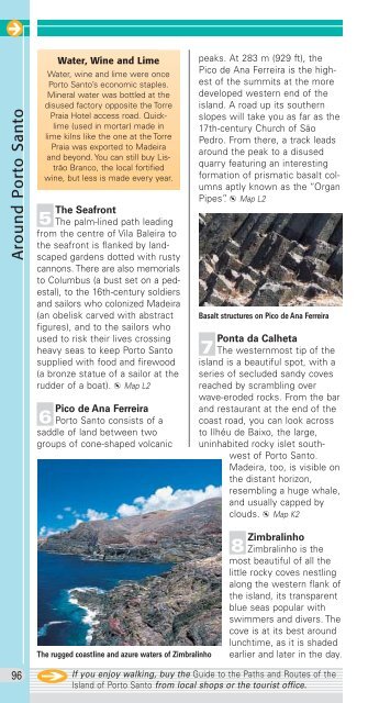
The rugged coastline and azure waters of Zimbralinho<br />
peaks. At 283 m (929 ft), the<br />
Pico de Ana Ferreira is the highest<br />
of the summits at the more<br />
developed western end of the<br />
island. A road up its southern<br />
slopes will take you as far as the<br />
17th-century Church of São<br />
Pedro. From there, a track leads<br />
around the peak to a disused<br />
quarry featuring an interesting<br />
formation of prismatic basalt columns<br />
aptly known as the “Organ<br />
Pipes”. d Map L2<br />
Basalt structures on Pico de Ana Ferreira<br />
Ponta da Calheta & The westernmost tip of the<br />
island is a beautiful spot, with a<br />
series of secluded sandy coves<br />
reached by scrambling over<br />
wave-eroded rocks. From the bar<br />
and restaurant at the end of the<br />
coast road, you can look across<br />
to Ilhéu de Baixo, the large,<br />
uninhabited rocky islet southwest<br />
of Porto Santo.<br />
<strong>Madeira</strong>, too, is visible on<br />
the distant horizon,<br />
resembling a huge whale,<br />
and usually capped by<br />
clouds. d Map K2<br />
* Zimbralinho<br />
Zimbralinho is the<br />
most beautiful of all the<br />
little rocky coves nestling<br />
along the western flank of<br />
the island, its transparent<br />
blue seas popular with<br />
swimmers and divers. The<br />
cove is at its best around<br />
lunchtime, as it is shaded<br />
earlier and later in the day.<br />
If you enjoy walking, buy the Guide to the Paths and Routes of the<br />
Island of Porto Santo from local shops or the tourist office.