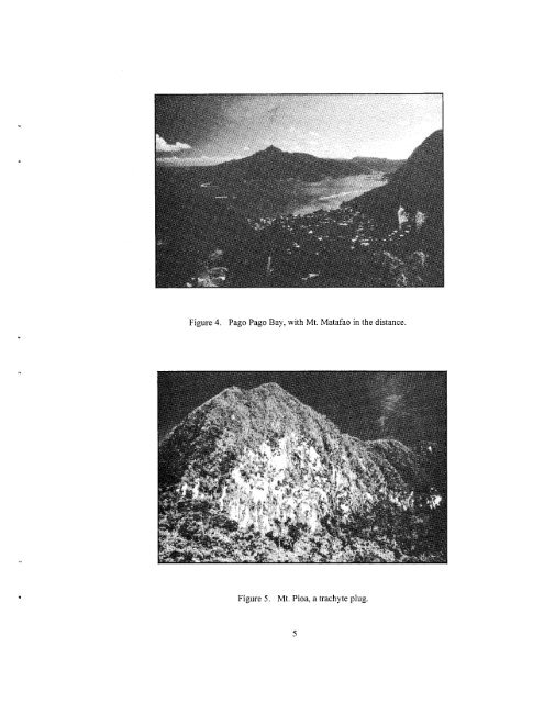
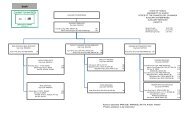
tuff and cinder cones, including the island <strong>of</strong> 'Aunu'u, but these eruptions are thousands <strong>of</strong> years old. There are no signs <strong>of</strong> recent volcanism within the boundaries <strong>of</strong> the proposed Tutuila park unit. Tutuila was cre<strong>at</strong>ed in a series <strong>of</strong> volcanic eruptions forming an island elong<strong>at</strong>ed in a east- west direction. 'This was followed by stream erosion and submergence, which has resulted in a rugged terrain and deeply embayed coastline. The most salient fe<strong>at</strong>ures <strong>of</strong> the island are the well-sheltered Pago Pago Bay (Fig. 4), the mountain peaks, such as Pioa (Fig. 5), otherwise known as "Rainmaker Mountain," and M<strong>at</strong>afao (see Fig. 4), the steep ridges ascending into the interior <strong>of</strong> the island, and the cliff-bound Tafuna plain and its associ<strong>at</strong>ed cr<strong>at</strong>ers. Pago Pago Harbor, which nearly bisects the island and lies just beyond the southern edge <strong>of</strong> the park, was formed in an ancient caldera th<strong>at</strong> was bounded on the east by Pioa, on the north by Alava Ridge, on the west by M<strong>at</strong>afao, and on the south by a now non-existent wall outside the mouth <strong>of</strong> the present day harbor. After the volcanic series ended, erosion <strong>of</strong> the center <strong>of</strong> the caldera and drowning <strong>of</strong> the valley produced the spectacular present day harbor th<strong>at</strong> parallels the southern slope <strong>of</strong> Alava Ridge (maximum elev<strong>at</strong>ion 490 m) which marks the southern boundary <strong>of</strong> the proposed park. Between the east and west ends <strong>of</strong> the park, which are marked by Afono and Fagasa villages, rcspectivcly, are a series <strong>of</strong> steep-sided ridges and stream valleys th<strong>at</strong> radi<strong>at</strong>e out from Alava Ridge and cxtend down to the north coast <strong>of</strong> the island. The most spectacular <strong>of</strong> these is the one <strong>at</strong> V<strong>at</strong>ia th<strong>at</strong> extends out to a steep-sided peninsula (Polauta) and Pola Islet (Fig. 6). With the exception <strong>of</strong> V<strong>at</strong>ia village, the north coast <strong>of</strong> the park is rugged and uninhabited. Most <strong>of</strong> these stream valleys are narrow and steep-sided, but Amalau Valley, with its scenic cliffs and w<strong>at</strong>erfalls, is a short, amphithe<strong>at</strong>er valley (Fig. 7). The whole coastline <strong>of</strong> the park is steep and rugged, and the only sandy beaches are found in V<strong>at</strong>ia village, Amalau Bay, and on the west side <strong>of</strong> Polauta. The park, consequently, is formed mostly by the caldera north wall and the eroded northern slopes <strong>of</strong> the ancient volcano. South <strong>of</strong> both ends and beyond the boundaries <strong>of</strong> the park are the two previously noted peaks, Pioa and M<strong>at</strong>afao, which are classified as trachyte plugs-cores <strong>of</strong> ancient volcanoes th<strong>at</strong> remain after the cr<strong>at</strong>er rims have eroded away. Eight <strong>of</strong> these trachyte plugs are found on Tutuila (Steams 1944), the largest two <strong>of</strong> which are Pioa and M<strong>at</strong>afao. These plugs are comprised <strong>of</strong> a fine-grained, highly eroded, cream-colored trachyte rock th<strong>at</strong> is chara- cterized by a predominance <strong>of</strong> potassium feldspar. The light color <strong>of</strong> the soil is evident in the cliffs <strong>of</strong> Pioa (see Fig. 5). This soil is generally low in important minerals, which results in a stunted, scrubby veget<strong>at</strong>ion called montane scrub (see the discussion on plant communties below) on the slopes and summits <strong>of</strong> these trachyte plugs. Although these two peaks are outside the park boundaries, a trachyte plug ridge <strong>of</strong> equal size but lower elev<strong>at</strong>ion, forms the spectacular Pola Islet and Polauta Ridge just north <strong>of</strong> V<strong>at</strong>ia village. Floristic Studies on Tutuila The first collections <strong>of</strong> plant specimens from Tutuila were made during the visit <strong>of</strong> the United St<strong>at</strong>es Exploring Expedition (USEE) to Samoa in 1839. The specimens, collected by W. Bracken- ridge, W. Rich, and C. Pickering, are now stored <strong>at</strong> the Smithsonian Institution and the Gray Herbarium, with some duplic<strong>at</strong>es <strong>at</strong> other institutions such as Kew. Unfortun<strong>at</strong>ely, the specimens were poorly cur<strong>at</strong>ed, and mistakes in locality are not uncommon. In fact, some specimens <strong>of</strong> endemic Samoan plants were incorrectly labeled as having been collected in Tahiti. Even the correctly labeled USEE specimens cite only "Samoa" as the locality, so it is not certain which ones were collected from Tutuila -although there is some indic<strong>at</strong>ion from the published list <strong>of</strong> USEE specimens (Pickering 1876). The next plant collector to visit Tutuila was apparently the Rev. T. Powell, an am<strong>at</strong>eur English botanist employed as a missionary by the London Missionary Society in Samoa (ca. 1862-1885). Powell collected about 630 numbered specimens in Samoa, and many others th<strong>at</strong> are unnumbered. Unfortun<strong>at</strong>ely, most <strong>of</strong> the specimens lack localities, so it is impossible to determine which ones were collected on Tutuila and which ones on the other islands (he is known to have collected on Savai'i,
Figure 4. Pago Pago Bay, with Mt. M<strong>at</strong>afao in the distance. Figure 5. Mt. Pioa, a trachyte plug.
- Page 1 and 2: COOPERATIVE NATIONAL PARK RESOURCES
- Page 3 and 4: TABLE OF CONTENTS I . INTRODUCTION
- Page 5 and 6: LEGEND B \ PROPOSED PARK AREA OFU I
- Page 7: Figure 3 VEGETATION TYPE MAP Tutuil
- Page 11 and 12: 'IJpolu, and 'Ta'u as well). The on
- Page 13 and 14: nu pucijicuJ; an Eurya? [Eurya pick
- Page 15 and 16: category recognized in the report o
- Page 17 and 18: Figure 10. Tuafanua Beach west of V
- Page 19 and 20: Figure 12. Littoral shrubland veget
- Page 21 and 22: Figure 14. Littoral shrubland veget
- Page 23 and 24: Figure 16. Littoral forest north of
- Page 25 and 26: Soils differ in origin and age of t
- Page 27 and 28: example on Tutuila is the climbing
- Page 29 and 30: When undisturbed, the floor of the
- Page 31 and 32: incrme (aloalo tai) may also be com
- Page 34 and 35: coastal ridges, decreases in import
- Page 36 and 37: Scvcral other trees are characteris
- Page 38 and 39: poIvon/l~os, Dtrvulliu solidu (whic
- Page 40 and 41: Although Mauga-o-Tula lacks some of
- Page 42 and 43: introduced weeds, many of the Polyn
- Page 44 and 45: even mature secondary forest, it le
- Page 46 and 47: there). No increased access should
- Page 48 and 49: Whistler, W. A. 1976. Wetlands of A
- Page 50 and 51: Acrostichum aureum L. [swamp fern]
- Page 52 and 53: Uncommon in montane to cloud forest
- Page 54 and 55: 171 ; Setchell 393; Christophersen
- Page 56 and 57: of the costa. Uncommon in montane t
- Page 58 and 59:
liom China to I'itcairn Island. USE
- Page 60 and 61:
lamina deeply cut into 1-10 lobes,
- Page 62 and 63:
Antrophyum alatum Bracken. VITTARIA
- Page 64 and 65:
weed in villages and along roadside
- Page 66 and 67:
650 111 clevi~tion. A modern introd
- Page 68 and 69:
Vernonia cinerea (L.) Less. [ironwe
- Page 70 and 71:
Uncomnion in secondary forest, prob
- Page 72 and 73:
from near sea level to 400 m elevat
- Page 74 and 75:
*Charnaesyce prostrata (Ait.) Small
- Page 76 and 77:
elevation. A modern introduction, n
- Page 78 and 79:
Macroptilium lathyroides (L.) Urb.
- Page 80 and 81:
Cyrtandra samoensis A. Gray momolea
- Page 82 and 83:
'Thespesia populnea (L.) Sol. ex Co
- Page 84 and 85:
Ficus prolixa Forst. f. [banyan] ao
- Page 86 and 87:
found in Tonga, Futuna, and Fiji. S
- Page 88 and 89:
Peperomia pellucida (L,.) Kunth POL
- Page 90 and 91:
*Gardenia taitensis DC. "Hedyotis c
- Page 92 and 93:
elevation. This species should be t
- Page 94 and 95:
"Physalis angulata L. 1 wild cape g
- Page 96 and 97:
*Etatosterna scabriusculum Setchell
- Page 98 and 99:
Epipremnum pinnaturn (L.) Engl. Ili
- Page 100 and 101:
Mariscus secmannianus (Boeck.) Pall
- Page 102 and 103:
*Bulbophyllurn samoanum Schlechter
- Page 104 and 105:
Malaxis resupinata (Forst. f.) Kunt
- Page 106 and 107:
F. homhronii Mart.; it differs from
- Page 108 and 109:
this in D. ciliaris, but the two ha
- Page 110 and 111:
Paspalurn orbiculare Forst. f. Mcdi
- Page 112 and 113:
APPENDIX B: PLOT DATA (Basal area i
- Page 114 and 115:
PLOT 4: MULIULU LOWLAND RIDGE FORES
- Page 116 and 117:
PLOT 6: TIATAUALA LOWLAND RIDGE FOR
- Page 118 and 119:
PLOT 8: OLO LOWLAND RIDGE FOREST (2
- Page 120 and 121:
PLOT 10: AMALAU LOWLAND VALLEY FORE
- Page 122 and 123:
PLOT 12: ALAVA MONTANE FOREST* (400
- Page 124 and 125:
APPENDIX C: SEASONALITY OF IMPORTAN
- Page 126 and 127:
MORACEAE Ikus godcfl'royi 1;icus ob
- Page 128 and 129:
SPECIES FAMILY FLOWERING DATES FRUI
- Page 130 and 131:
2. Littoral Shrubland Two types of
- Page 132 and 133:
the relatively undisturbed places,
- Page 134 and 135:
harvcyana (laupata), Morinda citrif
- Page 136 and 137:
APPENDIX F. SUMMARY OF THE VASCULAR
- Page 138 and 139:
VIlTAKIACEAE Amrophyurn alaturn Ant
- Page 140 and 141:
Species FAMILY Status* E I P M ....
- Page 142 and 143:
MYRSINACEAE Embelia vaupelii Maesa
- Page 144 and 145:
Species FAMILY Status* E I P M VEKB
- Page 146:
...................................