DARLING RIVERINE PLAINS BIOREGION Background Report
DARLING RIVERINE PLAINS BIOREGION Background Report
DARLING RIVERINE PLAINS BIOREGION Background Report
You also want an ePaper? Increase the reach of your titles
YUMPU automatically turns print PDFs into web optimized ePapers that Google loves.
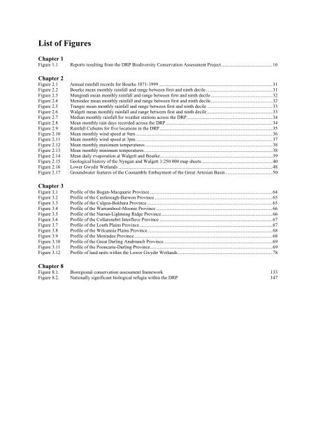
List of Figures<br />
Chapter 1<br />
Figure 1.1 <strong>Report</strong>s resulting from the DRP Biodiversity Conservation Assessment Project ..........................................16<br />
Chapter 2<br />
Figure 2.1 Annual rainfall records for Bourke 1871-1999..............................................................................................31<br />
Figure 2.2 Bourke mean monthly rainfall and range between first and ninth decile.......................................................31<br />
Figure 2.3 Mungindi mean monthly rainfall and range between first and ninth decile...................................................32<br />
Figure 2.4 Menindee mean monthly rainfall and range between first and ninth decile...................................................32<br />
Figure 2.5 Trangie mean monthly rainfall and range between first and ninth decile ......................................................33<br />
Figure 2.6 Walgett mean monthly rainfall and range between first and ninth decile......................................................33<br />
Figure 2.7 Median monthly rainfall for weather stations across the DRP.......................................................................34<br />
Figure 2.8 Mean monthly rain days recorded across the DRP ........................................................................................34<br />
Figure 2.9 Rainfall CuSums for five locations in the DRP .............................................................................................35<br />
Figure 2.10 Mean monthly wind speed at 9am.................................................................................................................36<br />
Figure 2.11 Mean monthly wind speed at 3pm.................................................................................................................37<br />
Figure 2.12 Mean monthly maximum temperatures .........................................................................................................38<br />
Figure 2.13 Mean monthly minimum temperatures..........................................................................................................38<br />
Figure 2.14 Mean daily evaporation at Walgett and Bourke.............................................................................................39<br />
Figure 2.15 Geological history of the Nyngan and Walgett 1:250 000 map sheets ..........................................................40<br />
Figure 2.16 Lower Gwydir Wetlands ...............................................................................................................................48<br />
Figure 2.17 Groundwater features of the Coonamble Embayment of the Great Artesian Basin.......................................50<br />
Chapter 3<br />
Figure 3.1 Profile of the Bogan-Macquarie Province .....................................................................................................64<br />
Figure 3.2 Profile of the Castlereagh-Barwon Province .................................................................................................65<br />
Figure 3.3 Profile of the Culgoa-Bokhara Province........................................................................................................65<br />
Figure 3.4 Profile of the Warrambool-Moonie Province ................................................................................................66<br />
Figure 3.5 Profile of the Narran-Lightning Ridge Province............................................................................................66<br />
Figure 3.6 Profile of the Collarenebri Interfluve Province .............................................................................................67<br />
Figure 3.7 Profile of the Louth Plains Province..............................................................................................................67<br />
Figure 3.8 Profile of the Wilcannia Plains Province.......................................................................................................68<br />
Figure 3.9 Profile of the Menindee Province..................................................................................................................68<br />
Figure 3.10 Profile of the Great Darling Anabranch Province..........................................................................................69<br />
Figure 3.11 Profile of the Pooncarie-Darling Province.....................................................................................................69<br />
Figure 3.12 Profile of land units within the Lower Gwydir Wetlands ..............................................................................78<br />
Chapter 8<br />
Figure 8.1. Bioregional conservation assessment framework 133<br />
Figure 8.2. Nationally significant biological refugia within the DRP 147


