

DARLING RIVERINE PLAINS BIOREGION Background Report
DARLING RIVERINE PLAINS BIOREGION Background Report
DARLING RIVERINE PLAINS BIOREGION Background Report

You also want an ePaper? Increase the reach of your titles
YUMPU automatically turns print PDFs into web optimized ePapers that Google loves.
16/08/02 Darling Riverine Plains Bioregion <strong>Background</strong> <strong>Report</strong><br />
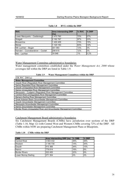
Table 1.8 RVCs within the DRP<br />
RVC Area intersecting DRP<br />
(ha)<br />
% RVC % DRP<br />
Lower Macquarie – Castlereagh 2 470 760 72% 27%<br />
Walgett 2 162 767 97% 23%<br />
Brewarrina 1 400 409 73% 15%<br />
Moree 1 120 193 63% 12%<br />
Nth Lachlan – Bogan 301 993 13% 3%<br />
Narrabri – Coonabarabran – Coolah 298 615 12% 3%<br />
Mid – Lachlan 18 948 1% 0.2%<br />
Water Management Committee administrative boundaries<br />
Water management committees established under the Water Management Act, 2000 whose<br />
coverages fall within the DRP are listed in Table 1.9.<br />
Table 1.9 Water Management Committees within the DRP<br />
(DLWC 2001a)<br />
Water Management Committee<br />
Gwydir River (Regulated) River Management Committee<br />
Namoi Regulated River Management Committee<br />
Gwydir Unregulated River Management Committee<br />
Namoi Unregulated River Management Committee<br />
Macquarie – Cudgeon (Regulated) River Management Committee<br />
Central West (Unregulated) River Management Committee<br />
Barwon-Darling River Management Committee<br />
Great Artesian Basin Groundwater Management Committee<br />
Gwydir Groundwater Management Committee<br />
Macquarie Groundwater Management Committee<br />
Namoi Groundwater Management Committee<br />
Border Rivers Unregulated River and Groundwater Management Committee<br />
Catchment Management Board administrative boundaries<br />
Six Catchment Management Boards (CMBs) have jurisdiction over sections of the DRP<br />
(Table 1.10, Map 12) with Central West and Western CMBs covering 72% of the DRP. All<br />
CMBs within NSW are preparing Catchment Management Plans or Blueprints.<br />
Table 1.10 CMBs within the DRP<br />
CMB Area intersecting DRP (ha) % CMB % DRP<br />
Central West 3 563 432 39% 38%<br />
Western 3 190 730 14% 34%<br />
Gwydir 910 366 34% 10%<br />
Namoi 779 814 19% 8%<br />
Border Rivers 522 455 22% 6%<br />
Lower Murray Darling 271 354 4% 4%<br />
26


