DARLING RIVERINE PLAINS BIOREGION Background Report
DARLING RIVERINE PLAINS BIOREGION Background Report
DARLING RIVERINE PLAINS BIOREGION Background Report
You also want an ePaper? Increase the reach of your titles
YUMPU automatically turns print PDFs into web optimized ePapers that Google loves.
16/08/02 Darling Riverine Plains Bioregion <strong>Background</strong> <strong>Report</strong><br />
(myall) community, for example, has greatly diminished as a community and is not well<br />
conserved (Mitchell 1991).<br />
The pre-1750 vegetation of the DRP bioregion has been substantially modified but not in a<br />
consistent way or degree throughout the bioregion. In the eastern portion, clearing of the<br />
forests and woodlands on the productive alluvial plains has left an extensively changed<br />
landscape, one dominated by agricultural uses and containing only small patches of remnant<br />
native vegetation communities. In the western semi-arid portion of the bioregion the initial<br />
effects of overgrazing were extreme, but with changes in management there has been some<br />
recovery of the vegetative cover. In general terms there has been a shift from woodland to a<br />
larger proportion of grassland but of different and predominantly introduced species.<br />
3.2 VEGETATION MAPPING AND DESCRIPTION IN THE DRP<br />
Vegetation mapping covering the DRP is limited to very broad-scale datasets, with some<br />
detailed mapping of small areas. Only the Murray Darling Basin Commission basin-wide<br />
mapping of structural and floristic attributes of the vegetation (M305) covers the entire DRP<br />
(MDBC 1991) (Map 24). This M305 mapping indicates that only 6.2% of the DRP is now<br />
covered with woody vegetation. In the Macquarie catchment 6.4% of the area is covered with<br />
woody vegetation (M305). Eucalyptus populnea subsp. bimbil (bimble box) communities are<br />
dominant, but are in poor health, with the grassy/herbaceous E. populnea subsp. bimbil<br />
woodland of the relic floodplains being severely fragmented through cropping, while the<br />
more shrubby E. populnea subsp. bimbil woodlands have been largely affected by grazing,<br />
thinning, ring-barking and cropping (Lewer, S., DLWC, pers. com. Dec. 2001). Understorey<br />
species have almost completely disappeared and less than 13% of the region retains natural<br />
pastures (MDBC 1991; Macquarie 2100 report). The value of the M305 vegetation mapping<br />
is limited, as it omits native grasslands and shrublands with less than 20% woody cover and<br />
provides no specific indication of species composition or community health.<br />
The precision, scale, methodology and coverage of mapping with floristic interpretation<br />
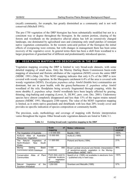
varies throughout the region. Other broad-scale vegetation datasets are listed in Table 3.1.<br />
Table 3.1 Existing broad-scale vegetation mapping in the DRP<br />
Dataset Scale of<br />
mapping<br />
Notes / references<br />
62<br />
% of DRP<br />
covered<br />
The Vegetation of Australia 1:10 000 000 Beadle (1981) 100%<br />
AUSLIG Atlas of Australian 1:5 000 000 AUSLIG (1990) 100%<br />
Resources: Vegetation<br />
The Natural Vegetation of 1:1 000 000 Pickard and Norris (1994) 21%<br />
North-Western<br />
Wales<br />
New South<br />
Murray Darling Basin 1:100 000 Broad Landsat structural and floristic interpretation 98%<br />
Commission M305 Datalayer (nominal)<br />
of woody/non-woody vegetation in the Murray-<br />
Darling Basin (MDBC 1991).<br />
Conservation Atlas of Plant Point data used to Specht et al. (1995) not available in electronic form 100%<br />
Communities<br />
estimate locations – published only in hard copy.<br />
of vegetation<br />
Natural Vegetation of the<br />
communities<br />
1:250 000 Sivertsen and Metcalfe (1995) 57%<br />
Southern Wheatbelt


