

DARLING RIVERINE PLAINS BIOREGION Background Report
DARLING RIVERINE PLAINS BIOREGION Background Report
DARLING RIVERINE PLAINS BIOREGION Background Report

You also want an ePaper? Increase the reach of your titles
YUMPU automatically turns print PDFs into web optimized ePapers that Google loves.
16/08/02 Darling Riverine Plains Bioregion <strong>Background</strong> <strong>Report</strong><br />
Pungbougal lagoon, Great Artesian Basin springs, and the Culgoa River floodplain are<br />
recognised as wetlands of importance in Australia (Environment Australia 2001d). The<br />
wetlands and rivers of the DRP also feed two river Ramsar sites downstream in South<br />
Australia; ie Riverland Ramsar site adjacent to the Murray River and Coorong and Lakes<br />
Alexandrina and Albert Ramsar site at the mouth of the Murray River (Ellis, M., NPWS, pers.<br />
com. Dec. 2001).<br />
Other wetlands occur throughout the bioregion including some 200 defined within the<br />
Walgett to Bourke section of the Darling-Barwon River alone (DLWC 1999). The<br />
significance of these smaller wetlands has not been fully assessed but they are critical for the<br />
movement of waterbirds between larger habitats. Much of the bioregion is characterised by<br />
smaller temporary to permanent wetlands, often known as cowals.<br />
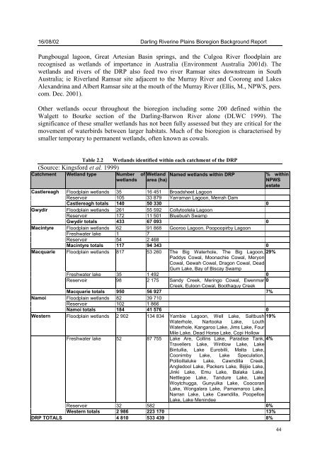
Table 2.2 Wetlands identified within each catchment of the DRP<br />
(Source: Kingsford et al. 1999)<br />
Catchment Wetland type Number of Wetland<br />
wetlands area (ha)<br />
Named wetlands within DRP % within<br />
NPWS<br />
estate<br />
Castlereagh Floodplain wetlands 35 16 451 Broadsheet Lagoon<br />
Reservoir 105 33 879 Yarraman Lagoon, Merrah Dam<br />
Castlereagh totals 140 50 330 0<br />
Gwydir Floodplain wetlands 261 55 592 Collytootela Lagoon<br />
Reservoir 172 11 501 Bluebush Swamp<br />
Gwydir totals 433 67 093 0<br />
Macintyre Floodplain wetlands 62 91 868 Gooroo Lagoon, Poopoopirby Lagoon<br />
Freshwater lake 1 7<br />
Reservoir 54 2 468<br />
Macintyre totals 117 94 343 0<br />
Macquarie Floodplain wetlands 817 53 260 The Big Waterhole, The Big Lagoon, 29%<br />
Paddys Cowal, Moonachie Cowal, Meryon<br />
Cowal, Gewah Cowal, Dragon Cowal, Dead<br />
Gum Lake, Bay of Biscay Swamp<br />
Freshwater lake 35 1 492 0<br />
Reservoir 98 2 175 Sandy Creek, Meringo Cowal, Ewenmar 0<br />
Creek, Euloon Cowal, Boothaguy Creek<br />
Macquarie totals 950 56 927 7%<br />
Namoi Floodplain wetlands 82 39 710<br />
Reservoir 102 1 866<br />
Namoi totals 184 41 576 0<br />
Western Floodplain wetlands 2 902 134 834 Yambie Lagoon, Well Lake, Saltbush 19%<br />
Waterhole, Nartooka Lake, Louth<br />
Freshwater lake 52 87 755<br />
Waterhole, Kangaroo Lake, Jims Lake, Four<br />
Mile Lake, Dead Horse Lake, Copi Hollow<br />
Lake Are, Collins Lake, Paradise Tank, 4%<br />
Travellers Lake, Wintlow Lake, Lake<br />
Bintullia, Lake Eurobilli, Malta Lake,<br />
Coonimby Lake, Lake Speculation,<br />
Pollioillaluke Lake, Cawndilla Creek,<br />
Angledool Lake, Packers Lake, Bijijie Lake,<br />
Jinki Lake, Emu Lake, Balaka Lake,<br />
Nettlegoe Lake, Tandure Lake, Lake<br />
Woytchugga, Gunyulka Lake, Coocoran<br />
Lake, Wongalara Lake, Pamamaroo Lake,<br />
Narran Lake, Lake Cawndilla, Poopelloe<br />
Lake, Lake Menindee<br />
Reservoir 32 582 0%<br />
Western totals 2 986 223 170 13%<br />
DRP TOTALS 4 810 533 439 8%<br />
44


