Bushland Weeds Manual - Environmental Weeds Action Network
Bushland Weeds Manual - Environmental Weeds Action Network
Bushland Weeds Manual - Environmental Weeds Action Network

You also want an ePaper? Increase the reach of your titles
YUMPU automatically turns print PDFs into web optimized ePapers that Google loves.
The most serious threats to plant communities across<br />
the wetlands are South African geophytes. Harlequin<br />
Flower (Sparaxis bulbifera) in particular is present on<br />
the edges of the claypans, throughout the wet flats and<br />
up into the Marri woodlands. It produces vast amounts<br />
of viable seed that germinate each year. Other South<br />
African geophytes that threaten the wetland flora<br />
include Watsonia species, One Leaf Cape Tulip (Moraea<br />
flaccida), Babiana (Babiana angustifolia), Wavy Gladiolus<br />
(Gladiolus undulatus) and Freesia. The South African<br />
grass Tribolium uniolae is a relatively recent invader but<br />
frequent fire in wetlands appears to be facilitating its<br />
movement into otherwise undisturbed areas. Annual<br />
weeds are prolific around the disturbed edges. The<br />
annual sedge Isolepis hystrix is a particularly serious<br />
weed forming dense mats in low-lying wetter areas.<br />
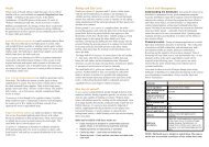
Most of the on-ground management at Brixton Street is<br />
carried out by the Friends of Brixton Street Wetlands; a<br />
community group formed to save the wetlands from<br />
housing development in the early 1990s. The land is still<br />
vested in the state housing authority, Homeswest, and<br />
has been due to transfer to the Department of<br />
Conservation and Land Management (DCLM) for the last<br />
nine years. Management guidelines for the wetlands<br />
have been produced by the Wildflower Society of<br />
Western Australia (Inc.) with financial assistance from a<br />
Community Conservation grant (Keighery and Keighery<br />
1995). DCLM plays some role in management as the area<br />
supports rare flora and threatened plant communities. A<br />
management group with representatives from the<br />
Friends, the Wildflower Society, DCLM, and the City of<br />
Gosnells meets on an irregular basis.<br />
Funding for weed management and bush regeneration<br />
work in recent years has come from the Perth Branch of<br />
the Wildflower Society, DCLM and the City of Gosnells.<br />
Elizabeth Buters, Friends of Brixton Street Wetlands.<br />
Talbot Road <strong>Bushland</strong><br />
Talbot Road <strong>Bushland</strong>, a 95 hectare remnant, lies at the<br />
foot of Darling Scarp on the soils of the Ridgehill Shelf.<br />
Marri, Jarrah and Wandoo (Eucalyptus wandoo)<br />
woodlands occur on the heavier soils and Banksia<br />
woodlands and shrublands on the sandier soils. The<br />
woodlands support an exceedingly diverse understorey<br />
of shrubs, herbs and sedges. Around 366 taxa, many of<br />
Chapter 1 The Project<br />
them rare or restricted, occur across the bushland. It is<br />
the most significant area of Ridgehill Shelf vegetation<br />
remaining and the floristic communities are considered<br />
critically endangered (Keighery and Keighery 1993,<br />
Government of Western Australia 2000). Around 90 % of<br />
the bushland is in good to excellent condition but there<br />
are areas of severe localised disturbance - around drains,<br />
paths and a gravel pit. Around 55 species of weeds occur<br />
in the bushland (Brown and Brooks unpubl.).<br />
The most widespread serious weed in the Talbot Road<br />
<strong>Bushland</strong> is the South African geophyte Hesperantha<br />
falcata. It occurs along path edges throughout the<br />
reserve, moving into undisturbed bushland on the<br />
heavier soils. Other South African geophytes are still<br />
quite localised in their distribution. These include<br />
Freesia, Babiana and Watsonia species. South African<br />
grasses are the other group of serious weeds with<br />
Perennial Veldgrass widespread on the sandier soils<br />
and African Lovegrass (Eragrostis curvula) occurring<br />
across disturbed areas of the bushland.<br />
Talbot Road is vested in the City of Swan and managed<br />
by a committee made up of representatives from the<br />
Friends of Talbot Road, the Department of <strong>Environmental</strong><br />
Protection, DCLM and the City of Swan. Much of the onground<br />
management is carried out by the Friends with<br />
DCLM and the City of Swan playing a significant role. A<br />
Natural Heritage Trust grant to the management group to<br />
implement a management plan (Environs Consulting<br />
1999) has provided consistent funding for weed<br />
management work over the last three years.<br />
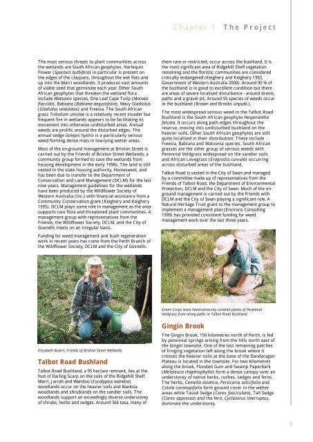
Green Corps team hand-removing isolated plants of Perennial<br />
Veldgrass from along paths in Talbot Road <strong>Bushland</strong>.<br />
Gingin Brook<br />
The Gingin Brook, 150 kilometres north of Perth, is fed<br />
by perennial springs arising from the hills north east of<br />
the Gingin townsite. One of the last remaining patches<br />
of fringing vegetation left along the brook where it<br />
crosses the heavier soils at the base of the Dandaragan<br />
Plateau is located in the townsite. For two kilometres<br />
along the brook, Flooded Gum and Swamp Paperbark<br />
(Melaleuca rhaphiophylla) form a dense canopy over an<br />
understorey of native herbs, rushes, sedges and ferns.<br />
The herbs, Centella asiatica, Persicaria salicifolia and<br />
Cotula coronopifolia form ground cover in the wetter<br />
areas while Tassel Sedge (Carex fasciculata), Tall Sedge<br />
(Carex appressa) and the fern, Cyclosorus interruptus,<br />
dominate the understorey.<br />
3