

GROUND WATER IN NORTH-CENTRAL TENNESSEE
GROUND WATER IN NORTH-CENTRAL TENNESSEE
GROUND WATER IN NORTH-CENTRAL TENNESSEE

You also want an ePaper? Increase the reach of your titles
YUMPU automatically turns print PDFs into web optimized ePapers that Google loves.
96 <strong>GROUND</strong> <strong>WATER</strong> <strong>IN</strong> <strong>NORTH</strong>-<strong>CENTRAL</strong> <strong>TENNESSEE</strong><br />
ARTESIAN SPR<strong>IN</strong>GS<br />
A very few of the springs in north-central Tennessee seem to be<br />
artesian springs that is, they seem to issue under artesian pressure<br />
above the usual ground-water level. Such springs probably exist<br />
only where an underground solution channel becomes dammed or<br />
obstructed by slumping of the roof beds or by accumulation of silt<br />
so that water is trapped above the obstruction under hydrostatic<br />
pressure. Hence, artesian springs are most erratic in location, and<br />
the artesian area is wholly problematic. Big Spring (pi. 9, B; No.<br />
329, p. 233), 6K miles west of Lebanon, Wilson County, may be an<br />
artesian spring.<br />
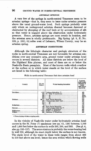
ARTESIAN CONDITIONS<br />
Although the lithologic character and geologic structure of the<br />
rocks in north-central Tennessee are not favorable for artesian con<br />
ditions over any extensive area, ground water under artesian head<br />
occurs in several districts. All these districts are below the level of<br />
the Highland Rim plateau, and most of them are on or below the<br />
Nashville Basin peneplain. Most of the known wells which overflow<br />
at the surface or in which water stands at the level of the surface<br />
are listed in the following table:<br />
Wells in north-central Tennessee that show artesian head<br />
County<br />
Robertson ____ . ________<br />
Wilson.............................<br />
0 Flows during winter or spring only.<br />
No. on<br />
Plate 4<br />
"275<br />
298<br />
299<br />
303<br />
198-A<br />
206<br />
216<br />
220<br />
74<br />
108<br />
120<br />
131<br />
a 355<br />
QOO<br />
Water-bearing formation<br />
.....do<br />
.....do...,. ... ... ... -<br />
.....do. ... . __ - _-..<br />
.....do . .._... -<br />
Approxi<br />
mate static<br />
altitude of<br />
water<br />
(feet above<br />
sea level)<br />
490<br />
490<br />
495±<br />
465(7)<br />
510<br />
550<br />
495<br />
715<br />
725<br />
470<br />
510<br />
730<br />
480<br />
645<br />
465<br />
In the vicinity of Nashville water under hydrostatic artesian head<br />
occurs in the St. Peter (?) sandstone (see pp. 61, 134) between 1,100<br />
and 1,490 feet below the surface in wells 295, 299, and 303. (See pi. 4,<br />
also pp. 135-137). The seme stratum is probably the water-bearing bed<br />
in well 298, although its exact depth below the surface is not known.<br />
The static level of the water in these wells ranges from about 465<br />
to 510 feet above sea level; hence the area within which flowing wells


