

GROUND WATER IN NORTH-CENTRAL TENNESSEE
GROUND WATER IN NORTH-CENTRAL TENNESSEE
GROUND WATER IN NORTH-CENTRAL TENNESSEE

Create successful ePaper yourself
Turn your PDF publications into a flip-book with our unique Google optimized e-Paper software.
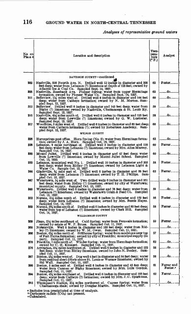
116 <strong>GROUND</strong> <strong>WATER</strong> <strong>IN</strong> <strong>NORTH</strong>-<strong>CENTRAL</strong> <strong>TENNESSEE</strong><br />
K"o on<br />
Place 4<br />
802<br />
305<br />
311<br />
312<br />
316<br />
317<br />
326<br />
v>&<br />
330<br />
QOQ<br />
**AA<br />
347<br />
348<br />
QKO<br />
353<br />
Location and description<br />
DATIDSON COUNTY continued<br />
Analyses of representative ground waters<br />
feet deep; water from Lebanon (?) limestone at depth of 128 feet; owned by<br />
Atlantic Ice & Coal Co. Sampled Sept. 14, 1927.<br />
formation; owned by Pioneer Water Co. Sampled Sept. 14, 1927.<br />
Belleview, 1M miles west of. Drilled well 6 inches in diameter and 144 feet<br />
deep; water from Catheys formation; owned by N. M. Morton. Sam<br />
pled Sept. 13, 1927.<br />
Belleview. Drilled well 6 inches in diameter and 143 feet deep; water from<br />
Bigby (?) limestone; owned by Nashville, Chattanooga & St. Louis Ry.<br />
Sampled Sept. 13, 1927.<br />
Nashville, 4J^ miles south of. Drilled well 6 inches in diameter and 125 feet<br />
deep; water from Lowville (?) limestone; owned by Q. W. Luetzeler.<br />
Sampled Sept. 13, 1927.<br />
Woodbine, 3 miles west of. Drilled well 6 inches in diameter and 65 feet deep;<br />
water from Catheys formation (?); owned by Robertson Academy. Sam<br />
pled Sept. 13, 1927.<br />
WILSON COUNTY<br />
Hornsprings post office. Horn Spi ing (No. 2) ; water from Hermitage forma<br />
tion; owned by J. A. Horn. Sampled Oct. 16, 1927.<br />
feet deep; water from Lebanon (?) limestone; owned by Mrs. Alice Murrey.<br />
Sampled Oct. 14, 1927.<br />
Mount Juliet. Drilled well 6 inches in diameter and 47 feet deep; water<br />
from Lowville (?) limestone; owned by Mount Juliet School. Sampled<br />
Oct. 15, 1930.<br />
feet deep; water from Ridley (?) limestone; owned by Lebanon Light &<br />
Water Co. Sample Oct. 13, 1927.<br />
deep; water from Lebanon (?) limestone; owned by T. H. Phillips. Sam<br />
pled Oct. 15, 1927.<br />
Watertown, J^ mile west of. Two drilled wells 6 inches in diameter and 251<br />
feet deep; water from Ridley (?) limestone; owned by city of Watertown;<br />
municipal supply. Sampled Oct. 13, 1927.<br />
Watertown. Drilled well 6 inches in diameter and 76 feet deep; water from<br />
Lebanon (?) limestone; owned by Watertown Grain & Feed Co. Sampled<br />
Oct. 13, 1927.<br />
deep; water from Lebanon (?) limestone; owned by Mrs. Bessie Hayes.<br />
Sampled Oct. 14, 1S27.<br />
water from top of Lebanon (?) limestone; owned by Clark Hill. Sampled<br />
Oct. 14, 1927.<br />
WILUAMSON COUNTY<br />
359 Jingo, 5Ji miles southeast of. Cold Spring; water from Fernvale formation;<br />
owned by estate of W. P. Brace. Sampled Oct. 11, 1927.<br />
365 Nolensville. Well 8 inches in diameter and 160 feet deep; water from Ridley<br />
(?) limestone; owned by W. M. Owen. Sampled Oct. 11, 1921.<br />
366 Boston, 6M miles north of. Stillhouse Spring; water from sandstone near top<br />
of Fort Payne formation; owned by city of Franklin; municipal supply (in<br />
part). Sampled Oct. 11, 1927.<br />
370 Franklin, 1 mile south of. Winder Spring; water from Hermitage formation;<br />
owned by C. H. Kinnard. Sampled Oct. 11, 1927.<br />
376 Arrington, 6M miles northwest of. Drilled well 6 inches in diameter and 132<br />
feet deep; water from Ridley limestone; owned by John N. Boxley. Sampled<br />
Oct. 11, 1927.<br />
387 Boston, 2M miles west of. Dug well 4 feet in diameter and 54 feet deep; water<br />
from residual chert debris above St. Louis or Warsaw limestone; owned by<br />
Sid Wall. Sampled Oct. 11, 1927.<br />
390 Boston, 5 miles east of. Drilled well 6 inches in diameter and 45 feet deep;<br />
water from Cannon or Bigby limestone; owned by Mrs. Lulu Gordon.<br />
Sampled Oct. 11, 1927.<br />
394 Boston, 4Ji miles southeast of. Drilled well 6 inches in diameter and 105 feet<br />
deep; water from Catheys (?) formation; owned by Mrs. J..C. Sparkman.<br />
Sampled Oct. 11, 1927.<br />
305 Thompson's Station, 3Ji miles northwest of. Cayces Spring; water from<br />
Chattanooga shale; owned by Douglas Martin. Sampled Oct. 11, 1927.<br />
«Includes iron precipitated at time of analysis.<br />
* Carbonate radicle (COs) not present.<br />
« Calculated.<br />
Tem<br />
pera<br />
ture<br />
(°F.)<br />
63<br />
62<br />
60<br />
59<br />
58<br />
60<br />
63<br />
60<br />
60<br />
58<br />
59<br />


