

GROUND WATER IN NORTH-CENTRAL TENNESSEE
GROUND WATER IN NORTH-CENTRAL TENNESSEE
GROUND WATER IN NORTH-CENTRAL TENNESSEE

You also want an ePaper? Increase the reach of your titles
YUMPU automatically turns print PDFs into web optimized ePapers that Google loves.
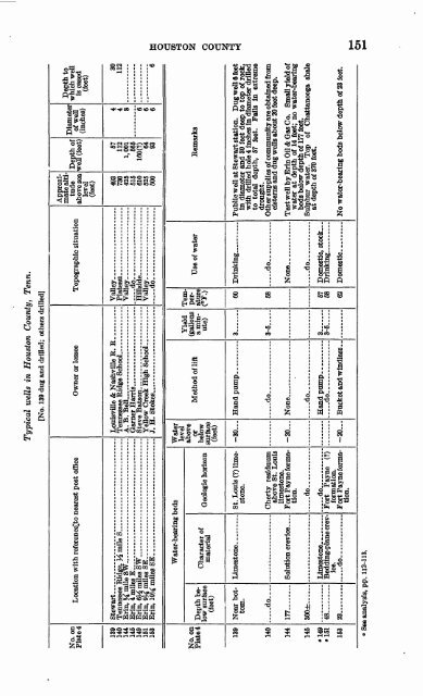
Typical wells in Houston County, Tenn.<br />
[No. 139 dug and drilled; others driHed]<br />
Depth to<br />
which well<br />
is cased<br />
(feet)<br />
Diameter<br />
of well<br />
(inches)<br />
Depth of<br />
well (feet)<br />
Approximatealtitude<br />
above sea<br />
level<br />
(feet)<br />
Topographic situation<br />
Owner or lessee<br />
Location with referencelto nearest post office<br />
No. on<br />
Plate 4<br />
30<br />
112<br />
57<br />
112<br />
1,001<br />
565<br />
6<br />
4<br />
4<br />
8<br />
6<br />
6<br />
160(?)<br />
64<br />
93<br />
493<br />
730<br />
425<br />
515<br />
610<br />
525<br />
500<br />
Vail ey-_ .....<br />
Plat<br />
Vail<br />
Hittside<br />
..... .....<br />
Vailey_<br />
....... ... ......<br />
io- ___ _. . __ .<br />
Lou isville & Nashville R. R<br />
Ten<br />
A T\.<br />
Bell.... ....... ...<br />
Oar<br />
Stev<br />
Yell<br />
j H.<br />
Stokes^ _____ ____ . __ .<br />
Stewart<br />
Tennessee<br />
Erin, % mi le SW. .... ... .... .....<br />
Erin, 4 mil<br />
Erin, % m ilesSW...-....... .......................<br />
Erin, 9J£ m ilesSE _____ . .......................<br />
Erin, 10M iniles<br />
SE ___ .. ____ .. ...... ...<br />
139<br />
140<br />
144<br />
145<br />
149<br />
151<br />
153<br />
Water<br />
level<br />
above<br />
or<br />
below<br />
surface<br />
(feet)<br />
Water-bearing beds<br />
Remarks<br />
Use of water<br />
Temperature<br />
(°F.)<br />
Yield<br />
(gallons<br />
a minute)<br />
Method of lift<br />
Depth below<br />
surface<br />
(feet)<br />
No. on<br />
Plate*<br />
Geologic horizon<br />
Character of<br />
material<br />
Public well at Stewart station. Dug well 6 feet<br />
in diameter and 30 feet deep to top of rock,<br />
with drilled hole 4 inches in diameter drilled<br />
to total depth, 57 feet. Fails in extreme<br />
drought.<br />
Other supplies of community are obtained from<br />
cisterns and dug wells about 20 feet deep.<br />
Test wen by Erin Oil & Gas Co. Small yield of<br />
water at depth of 14 feet; no water-bearing<br />
beds below depth of 177 feet.<br />
Sulphur water. Top of Chattanooga shale<br />
at depth of 370 feet.<br />
60<br />
3<br />
-30<br />
St. Louis (?) limestone.<br />
Near bottom.<br />
139<br />
... -do.. ...<br />
58<br />
3-5<br />
..... do.-<br />
Cherty residuum<br />
above St. Louis<br />
limestone.<br />
Fort Payne formation.<br />
... -do.. ...<br />
do ....... ...<br />
Fort Payne (?)<br />
formation.<br />
Fort Payne formation.<br />
do--<br />
140<br />
None... _<br />
None _ ... __ ...<br />
-20<br />
Solution crevice ....<br />
177<br />
144<br />
... -do..<br />
Domestic, stock.. .<br />
.....do _ ,<br />
300±<br />
145<br />
57<br />
68<br />
3 ...<br />
3-5<br />
.....do __ ___<br />
No water-bearing beds below depth of 23 feet.<br />
62<br />
-20<br />
Bedding-plane crevice,<br />
do<br />
48<br />
23<br />
"149<br />
151<br />
153<br />
1 See analysis, pp. 112-113.


