LAS SPECIFICATION VERSION 1.4 – R11 - asprs
LAS SPECIFICATION VERSION 1.4 – R11 - asprs
LAS SPECIFICATION VERSION 1.4 – R11 - asprs
You also want an ePaper? Increase the reach of your titles
YUMPU automatically turns print PDFs into web optimized ePapers that Google loves.
value sense) at which the laser point was output from the laser system including the roll of the<br />
aircraft. The scan angle is within 1 degree of accuracy from +90 to <strong>–</strong>90 degrees. The scan angle<br />
is an angle based on 0 degrees being nadir, and <strong>–</strong>90 degrees to the left side of the aircraft in the<br />
direction of flight.<br />
User Data: This field may be used at the user’s discretion.<br />
Point Source ID: This value indicates the file from which this point originated. Valid values for<br />
this field are 1 to 65,535 inclusive with zero being used for a special case discussed below. The<br />
numerical value corresponds to the File Source ID from which this point originated. Zero is<br />
reserved as a convenience to system implementers. A Point Source ID of zero implies that this<br />
point originated in this file. This implies that processing software should set the Point Source ID<br />
equal to the File Source ID of the file containing this point at some time during processing.<br />
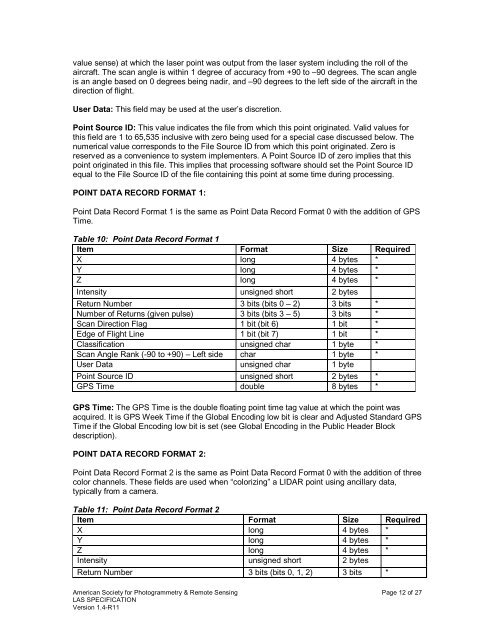
POINT DATA RECORD FORMAT 1:<br />
Point Data Record Format 1 is the same as Point Data Record Format 0 with the addition of GPS<br />
Time.<br />
Table 10: Point Data Record Format 1<br />
Item Format Size Required<br />
X long 4 bytes *<br />
Y long 4 bytes *<br />
Z long 4 bytes *<br />
Intensity unsigned short 2 bytes<br />
Return Number 3 bits (bits 0 <strong>–</strong> 2) 3 bits *<br />
Number of Returns (given pulse) 3 bits (bits 3 <strong>–</strong> 5) 3 bits *<br />
Scan Direction Flag 1 bit (bit 6) 1 bit *<br />
Edge of Flight Line 1 bit (bit 7) 1 bit *<br />
Classification unsigned char 1 byte *<br />
Scan Angle Rank (-90 to +90) <strong>–</strong> Left side char 1 byte *<br />
User Data unsigned char 1 byte<br />
Point Source ID unsigned short 2 bytes *<br />
GPS Time double 8 bytes *<br />
GPS Time: The GPS Time is the double floating point time tag value at which the point was<br />
acquired. It is GPS Week Time if the Global Encoding low bit is clear and Adjusted Standard GPS<br />
Time if the Global Encoding low bit is set (see Global Encoding in the Public Header Block<br />
description).<br />
POINT DATA RECORD FORMAT 2:<br />
Point Data Record Format 2 is the same as Point Data Record Format 0 with the addition of three<br />
color channels. These fields are used when “colorizing” a LIDAR point using ancillary data,<br />
typically from a camera.<br />
Table 11: Point Data Record Format 2<br />
Item Format Size Required<br />
X long 4 bytes *<br />
Y long 4 bytes *<br />
Z long 4 bytes *<br />
Intensity unsigned short 2 bytes<br />
Return Number 3 bits (bits 0, 1, 2) 3 bits *<br />
American Society for Photogrammetry & Remote Sensing Page 12 of 27<br />
<strong>LAS</strong> <strong>SPECIFICATION</strong><br />
Version <strong>1.4</strong>-<strong>R11</strong>


